File:Historical map of French autoroutes network - 1 sec.gif
Original file (1,195 × 1,179 pixels, file size: 4.77 MB, MIME type: image/gif, looped, 69 frames, 1 min 9 s)
Captions
Captions
Summary[edit]
| Description |
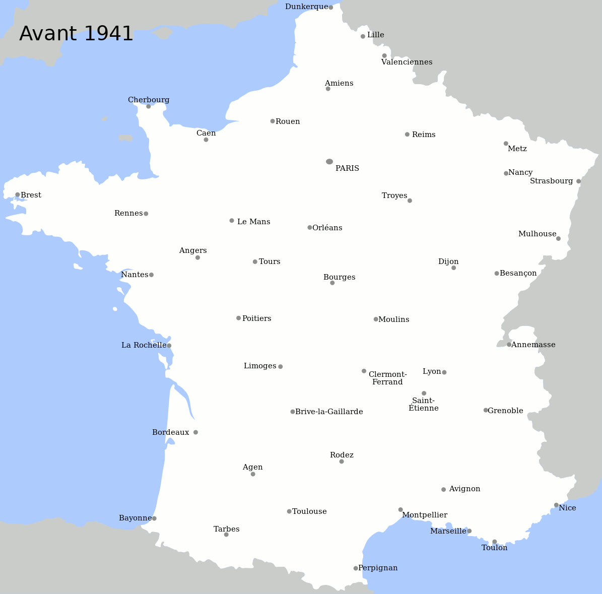
English: An animated map showing, for each year since 1941, the autoroute (motorway) sections opened in France. Previously existing sections are shown in black, new sections (i.e. sections opened between January 1 and December 31 of the considered year) are shown in red. Data is from [1].
Français : Une carte animée montrant, pour chaque année depuis 1941, les sections d'autoroutes ouvertes en France. Les autoroutes déjà ouvertes au 31 décembre de l'année précédant celle indiquée sont montrées en noir, celles ouvertes entre le 1er janvier et le 31 décembre de l'année indiquée sont en rouge. Source pour les dates d'ouverture : [2]. La date retenue n'est pas celle du classement autoroutier mais celle de l'ouverture, ou le cas échéant de la mise aux normes autoroutières, de la section, ou le cas échéant de la deuxième chaussée de la section considérée. Les voies express et voies rapides ne sont pas indiquées. |
| Date | February - March 2011 |
| Source | Own work |
| Author | Benjamin Smith |
| Other versions |
Licensing[edit]

|
Permission is granted to copy, distribute and/or modify this document under the terms of the GNU Free Documentation License, Version 1.2 or any later version published by the Free Software Foundation; with no Invariant Sections, no Front-Cover Texts, and no Back-Cover Texts. A copy of the license is included in the section entitled GNU Free Documentation License. |
- You are free:
- to share – to copy, distribute and transmit the work
- to remix – to adapt the work
- Under the following conditions:
- attribution – You must give appropriate credit, provide a link to the license, and indicate if changes were made. You may do so in any reasonable manner, but not in any way that suggests the licensor endorses you or your use.
- share alike – If you remix, transform, or build upon the material, you must distribute your contributions under the same or compatible license as the original.
Although this is not compulsory, I'm always glad to read that my work is useful to others. If you could send me an e-mail at benji dot wiki at gmail dot com to inform me that you are using my work, I'd be delighted. Thanks a lot!
Envie d'utiliser cette image en dehors des projets Wikimedia ? N'hésitez pas ! Cette image est placée sous licence libre de façon à ce que vous puissiez l'utiliser librement, sans avoir besoin d'une autorisation de ma part. Tout ce que vous devez faire, c'est respecter les termes de la licence et me créditer ainsi :
Bien que ce ne soit pas obligatoire, je suis toujours ravi d'apprendre que mon travail a été utile à d'autres. Si vous pouviez m'envoyer un courriel à benji point wiki arobase gmail point com pour m'informer du fait que vous utilisez mon travail, ce serait top. Merci d'avance !
File history
Click on a date/time to view the file as it appeared at that time.
| Date/Time | Thumbnail | Dimensions | User | Comment | |
|---|---|---|---|---|---|
| current | 14:47, 28 November 2021 | | 1,195 × 1,179 (4.77 MB) | Benjism89 (talk | contribs) | + years 2012 to 2019 |
| 07:45, 3 March 2011 |  | 1,195 × 1,179 (3.76 MB) | Benjism89 (talk | contribs) | {{Information |Description ={{en|1=An animated map showing, for each year since 1941, the ''autoroute'' (motorway) sections opened in France. Previously existing sections are shown in black, new sections (i.e. sections opened between January 1 and Dece |
You cannot overwrite this file.
File usage on Commons
The following 2 pages use this file: