File:Historical-Map Europa-Prima-Pars Terrae-in-Forma-Virginis C.P.1548 standing.jpg
Jump to navigation
Jump to search

Size of this preview: 433 × 599 pixels. Other resolutions: 173 × 240 pixels | 347 × 480 pixels | 555 × 768 pixels | 740 × 1,024 pixels | 1,300 × 1,799 pixels.
Original file (1,300 × 1,799 pixels, file size: 789 KB, MIME type: image/jpeg)
Captions
Captions
Add a one-line explanation of what this file represents
Summary[edit]
| Description |
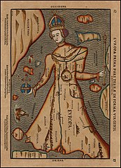
English: Historical Map (Heinrich Bünting ?): Europa Prima Pars, Terrae in Forma Virginis, signed C.P. 1548 (left side at top), standing version |
|||||||||||||||||||||||||
| Date | ca. 1582 ? (signed date at top left of map 1548) | |||||||||||||||||||||||||
| Source | WM: Europa Prima Pars Terrae in Forma Virginis.jpg; original: www.RareMaps.com | |||||||||||||||||||||||||
| Author |
Created or edited by Heinrich Bünting ?
|
|||||||||||||||||||||||||
| Other versions |
|
|||||||||||||||||||||||||


Licensing[edit]
|
This work is in the public domain in its country of origin and other countries and areas where the copyright term is the author's life plus 100 years or fewer. | |
| This file has been identified as being free of known restrictions under copyright law, including all related and neighboring rights. | |
File history
Click on a date/time to view the file as it appeared at that time.
| Date/Time | Thumbnail | Dimensions | User | Comment | |
|---|---|---|---|---|---|
| current | 13:28, 24 November 2012 | | 1,300 × 1,799 (789 KB) | Jaybear (talk | contribs) | {{Information |Description ={{en|1=Historical Map: ''Europa Prima Pars'', ''Terrae in Forma Virginis'', signed C.P. 1548 (left side at top), standing version}} |Source =[[:File:Europa Prima Pars Terrae in Forma Virginis.jpg|Europa Prima Pars... |
You cannot overwrite this file.
File usage on Commons
The following 2 pages use this file:
File usage on other wikis
The following other wikis use this file: