File:High Speed Railroad Map Europe 2008.gif
Jump to navigation
Jump to search
Size of this preview: 800 × 588 pixels. Other resolutions: 320 × 235 pixels | 640 × 470 pixels | 1,024 × 752 pixels | 1,280 × 940 pixels | 1,992 × 1,463 pixels.
Original file (1,992 × 1,463 pixels, file size: 299 KB, MIME type: image/gif)
Captions
Captions
Add a one-line explanation of what this file represents

|
File:High Speed Railroad Map of Europe 2015.svg is a vector version of this file. It should be used in place of this GIF file when not inferior.
File:High Speed Railroad Map Europe 2008.gif → File:High Speed Railroad Map of Europe 2015.svg
For more information, see Help:SVG. |
 |
Summary[edit]
| Description |
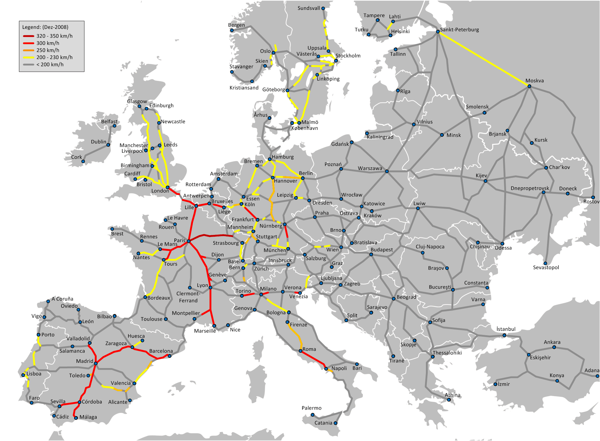
English: High Speed Railroad Network in Europe at the end of 2008. Note that this map only includes tracks in operation in 2008, and is labeled with maximum allowed speed, not designed speed. |
| Date | |
| Source | Own work |
| Author | Bernese media |
| Other versions |
 |
Licensing[edit]
I, the copyright holder of this work, hereby publish it under the following license:
This file is licensed under the Creative Commons Attribution-Share Alike 3.0 Unported license.
- You are free:
- to share – to copy, distribute and transmit the work
- to remix – to adapt the work
- Under the following conditions:
- attribution – You must give appropriate credit, provide a link to the license, and indicate if changes were made. You may do so in any reasonable manner, but not in any way that suggests the licensor endorses you or your use.
- share alike – If you remix, transform, or build upon the material, you must distribute your contributions under the same or compatible license as the original.
File history
Click on a date/time to view the file as it appeared at that time.
| Date/Time | Thumbnail | Dimensions | User | Comment | |
|---|---|---|---|---|---|
| current | 21:57, 16 July 2009 | | 1,992 × 1,463 (299 KB) | Bernese media (talk | contribs) | Please look on comment below. |
| 21:56, 16 July 2009 |  | 1,992 × 1,463 (299 KB) | Bernese media (talk | contribs) | Please note: This is a map of the high speed railroad net in Europe in 2008! All changes which did not take plase in 2008 have been removed. Please also have a look on the map of 2009. | |
| 17:28, 6 July 2009 |  | 1,793 × 1,316 (196 KB) | Jklamo (talk | contribs) | Updates in Belgium; LGV Perpignan-Figueres (not connected on spanish side, but completed) | |
| 21:34, 8 May 2009 |  | 1,793 × 1,316 (196 KB) | BIL (talk | contribs) | Adjusted Sweden, Finland and Norway. Based on de:Schnellfahrstrecke and File:Swedish highspeed rail map 2008 by BIL.png, and other maps. | |
| 15:41, 20 April 2009 |  | 1,793 × 1,316 (196 KB) | Jolly Janner (talk | contribs) | Reverted to version as of 15:56, 30 March 2009 | |
| 16:43, 18 April 2009 |  | 1,793 × 1,316 (185 KB) | Jolly Janner (talk | contribs) | Corrected Great Britain (no where in UK has speeds over 200km/h) | |
| 15:56, 30 March 2009 |  | 1,793 × 1,316 (196 KB) | Emturan (talk | contribs) | Milan-Bologna correction | |
| 15:47, 30 March 2009 |  | 1,793 × 1,316 (196 KB) | Emturan (talk | contribs) | a bit darker gray | |
| 15:24, 30 March 2009 |  | 1,793 × 1,316 (265 KB) | Emturan (talk | contribs) | Reverted to version as of 22:39, 28 February 2009 | |
| 15:22, 30 March 2009 |  | 1,793 × 1,316 (214 KB) | Emturan (talk | contribs) | land is re-painted with a bit lighter gray to make railroads more visible. |
You cannot overwrite this file.
File usage on Commons
The following 4 pages use this file:
File usage on other wikis
The following other wikis use this file:
- Usage on da.wikipedia.org
- Usage on de.wikipedia.org
- Usage on en.wikipedia.org