File:Henderson Island ESA392791.jpg

Original file (5,404 × 4,004 pixels, file size: 6.17 MB, MIME type: image/jpeg)
Captions
Captions
Summary[edit]
| Description |
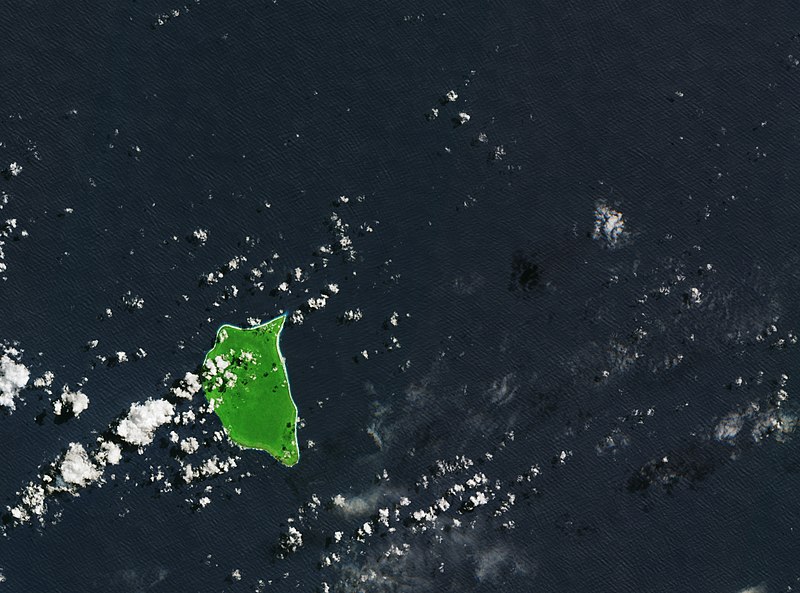
English: Henderson Island lies in the South Pacific, about halfway between New Zealand and Chile. As one of the best examples of a coral atoll, Henderson Island is a UN World Heritage site and one of the world’s biggest marine reserves. However, while this remote, uninhabited, tiny landmass may look idyllic and untouched by humans, it’s one of the most plastic-polluted places on Earth.
It is estimated that around 10 million tonnes of plastic ends up in the oceans every year. Carried by currents, it can form rubbish patches or eventually be washed up on shores far from where it entered the ocean. On Henderson, for example, items from as far afield as Russia, USA, Europe and South America have been found. Ocean plastic has serious consequences for wildlife and the environment. Marine animals not only get caught up in this plastic but also ingest it. Even when it has been broken down into microfragments by weathering and waves, it still endangers animals and also enters the food chain, with unknown long-term consequences for animal life and our own health. Celebrated every 22 April since 1970, Earth Day demonstrates support for environmental protection. This year, Earth Day is dedicated to providing information and inspiration needed to change our attitude towards plastic. This image, which was captured by the Copernicus Sentinel-2B satellite on 22 March 2018, is also featured on theEarth from Space video programme. |
| Date | |
| Source | http://www.esa.int/spaceinimages/Images/2018/04/Henderson_Island |
| Author | European Space Agency |
| Permission (Reusing this file) |
contains modified Copernicus Sentinel data (2018), processed by ESA,CC BY-SA 3.0 IGO |
| Other versions |
|
| Title | Henderson Island |
| Set | Earth observation image of the week |
| System | Copernicus |
| Mission | Sentinel-2 |
| Location | Pacific ocean |
| Activity | Observing the Earth |
| Keywords | Plastics; Pollution; Islands |
Licensing[edit]
- You are free:
- to share – to copy, distribute and transmit the work
- to remix – to adapt the work
- Under the following conditions:
- attribution – You must give appropriate credit, provide a link to the license, and indicate if changes were made. You may do so in any reasonable manner, but not in any way that suggests the licensor endorses you or your use.
- share alike – If you remix, transform, or build upon the material, you must distribute your contributions under the same or compatible license as the original.

|
This image contains data from a satellite in the Copernicus Programme, such as Sentinel-1, Sentinel-2 or Sentinel-3. Attribution is required when using this image.
Attribution: Contains modified Copernicus Sentinel data {{{year}}}
The use of Copernicus Sentinel Data is regulated under EU law (Commission Delegated Regulation (EU) No 1159/2013 and Regulation (EU) No 377/2014). Relevant excerpts:
Free access shall be given to GMES dedicated data [...] made available through GMES dissemination platforms [...].
Access to GMES dedicated data [...] shall be given for the purpose of the following use in so far as it is lawful:
GMES dedicated data [...] may be used worldwide without limitations in time.
GMES dedicated data and GMES service information are provided to users without any express or implied warranty, including as regards quality and suitability for any purpose. |
File history
Click on a date/time to view the file as it appeared at that time.
| Date/Time | Thumbnail | Dimensions | User | Comment | |
|---|---|---|---|---|---|
| current | 15:56, 20 April 2018 | | 5,404 × 4,004 (6.17 MB) | Fæ (talk | contribs) | European Space Agency, Id 392791, http://www.esa.int/spaceinimages/Images/2018/04/Henderson_Island, User:Fæ/Project_list/ESA |
You cannot overwrite this file.
File usage on Commons
The following 2 pages use this file: