File:Hawaiian Volcano Observatory (HVO), Hawaiʻi Volcanoes National Park, Hawaii (4528768779).jpg

Original file (2,816 × 2,112 pixels, file size: 3.02 MB, MIME type: image/jpeg)
Captions
Captions
Summary[edit]
,_Hawai%CA%BBi_Volcanoes_National_Park,_Hawaii_(4528768779).jpg&action=edit§ion=1)
| Description |
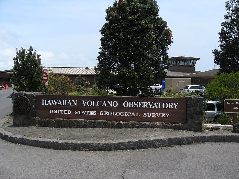
The Hawaiian Volcano Observatory (HVO) is a volcano observatory located at Uwekahuna Bluff on the rim of Kīlauea Caldera on the Island of Hawaiʻi. The observatory monitors four active Hawaiian volcanoes: Kīlauea, Mauna Loa, Hualālai, and Haleakalā. Because Kīlauea and Mauna Loa are significantly more active than Hualālai and Haleakalā, much of the observatory's research is concentrated on the former two mountains. The observatory has a worldwide reputation as a leader in the study of active volcanism. Due to the relatively non-explosive nature of Hawaiian volcanic eruptions, scientists can study on-going eruptions in proximity without being in extreme danger. Located at the main site is the public Thomas A. Jaggar Museum. Modern electronic equipment now monitors earthquakes from several sites. This information is provided immediately over the Internet, as well as live cameras covering the eruptions. Another important function of HVO is to monitor the sulphur emissions that produce the condition known as vog. The observatory advises the park service when to close areas due to dangerous hazards. While the main Observatory building itself is not open to the public, the adjacent Thomas A. Jaggar Museum includes interpretive exhibits on the work done at the observatory. The exhibits range from general information on volcanoes and lava to the scientific equipment and clothing used by volcanologists. Some of the museum's windows provide a sheltered view of the Kīlauea Caldera and Halemaʻumaʻu Crater. A public observation deck overlooking Kīlauea provides spectacular views. It a popular destination within Hawaii Volcanoes National Park, located on Crater Rim Drive west from the visitors center. en.wikipedia.org/wiki/Hawaiian_Volcano_Observatory en.wikipedia.org/wiki/Wikipedia:Text_of_Creative_Commons_... |
| Date | |
| Source | Hawaiian Volcano Observatory (HVO), Hawaiʻi Volcanoes National Park, Hawaii |
| Author | Ken Lund from Reno, Nevada, USA |
| Camera location | | View this and other nearby images on: OpenStreetMap |
|---|
,_Hawai%CA%BBi_Volcanoes_National_Park,_Hawaii_(4528768779).jpg¶ms=019.419877_N_-155.288100_E_globe:Earth_type:camera_source:Flickr_&language=en)
Licensing[edit]
,_Hawai%CA%BBi_Volcanoes_National_Park,_Hawaii_(4528768779).jpg&action=edit§ion=2)
- You are free:
- to share – to copy, distribute and transmit the work
- to remix – to adapt the work
- Under the following conditions:
- attribution – You must give appropriate credit, provide a link to the license, and indicate if changes were made. You may do so in any reasonable manner, but not in any way that suggests the licensor endorses you or your use.
- share alike – If you remix, transform, or build upon the material, you must distribute your contributions under the same or compatible license as the original.
| This image was originally posted to Flickr by Ken Lund at https://flickr.com/photos/75683070@N00/4528768779. It was reviewed on 9 January 2017 by FlickreviewR and was confirmed to be licensed under the terms of the cc-by-sa-2.0. |
File history
Click on a date/time to view the file as it appeared at that time.
| Date/Time | Thumbnail | Dimensions | User | Comment | |
|---|---|---|---|---|---|
| current | 03:43, 9 January 2017 | | 2,816 × 2,112 (3.02 MB) | Holly Cheng (talk | contribs) | Transferred from Flickr via Flickr2Commons |
You cannot overwrite this file.
File usage on Commons
The following page uses this file:
,_Hawaiʻi_Volcanoes_National_Park,_Hawaii_(4528768779).jpg&oldid=832170662)