File:Havel (Moosbeck) 19-07-2011 706.jpg
Jump to navigation
Jump to search

Size of this preview: 800 × 450 pixels. Other resolutions: 320 × 180 pixels | 640 × 360 pixels | 1,024 × 576 pixels | 1,280 × 720 pixels | 1,920 × 1,080 pixels.
Original file (1,920 × 1,080 pixels, file size: 1.57 MB, MIME type: image/jpeg)
Captions
Captions
Add a one-line explanation of what this file represents
Summary[edit]
_19-07-2011_706.jpg&action=edit§ion=1)
| Description |
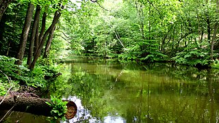
Deutsch: Die Havel zwischen Görtowsee und Zierzsee in der Neustrelitzer Kleinseenplatte. Sie gehört hier zum Müritz-Nationalpark und trägt in diesem ca. 750 m langen Abschnitt den Namen „Moosbeck“ (Gemeinde Roggentin, Landkreis Mecklenburg-Strelitz, Mecklenburg-Vorpommern). |
| Date | Taken in 19 July 2011 |
| Source | Own work |
| Author | Botaurus |
| Camera location | | View this and other nearby images on: OpenStreetMap |
|---|
_19-07-2011_706.jpg¶ms=053.350797_N_0012.950475_E_globe:Earth_type:camera_region:DE-MV_type:waterbody_scale:30000_&language=en)
Licensing[edit]
_19-07-2011_706.jpg&action=edit§ion=2)
| This work has been released into the public domain by its author, Botaurus. This applies worldwide. In some countries this may not be legally possible; if so: |
File history
Click on a date/time to view the file as it appeared at that time.
| Date/Time | Thumbnail | Dimensions | User | Comment | |
|---|---|---|---|---|---|
| current | 00:20, 20 July 2011 | | 1,920 × 1,080 (1.57 MB) | Botaurus-stellaris (talk | contribs) | == {{int:filedesc}} == {{Information |Description= {{de|1=Die Havel zwischen Görtowsee und Zierzsee in der Neustrelitzer Kleinseenplatte. Sie gehört hier zum Müritz-Nationalpark und trägt in diesem ca. 750 m langen Abschnitt den Namen „Moosbeck“ ( |
You cannot overwrite this file.
File usage on Commons
The following page uses this file:
File usage on other wikis
The following other wikis use this file:
- Usage on azb.wikipedia.org
- Usage on es.wikipedia.org
- Usage on ru.wikipedia.org
_19-07-2011_706.jpg&oldid=529881208)