File:Harvey Butchart's hiking map - Flickr - brewbooks (7).jpg
Original file (3,264 × 2,448 pixels, file size: 3.86 MB, MIME type: image/jpeg)
Captions
Captions
Summary[edit]
.jpg&action=edit§ion=1)
| Description |
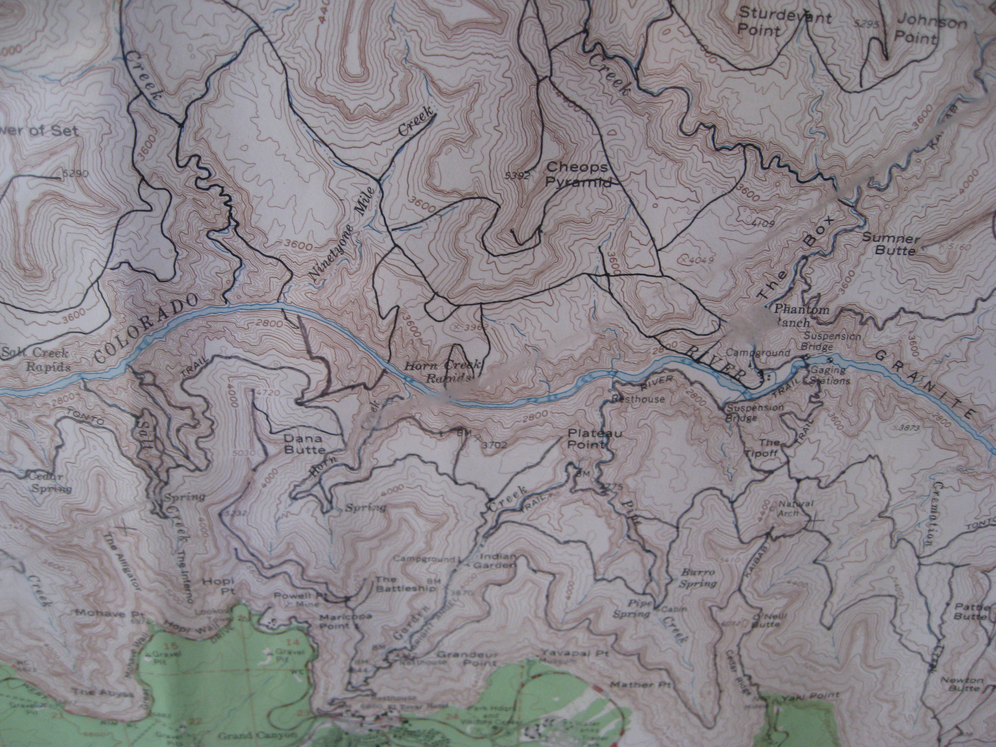
The Grand Canyon National Park Backcountry Office on the South Rim has a copy of Harvey Butchart's hiking map. After we finished our Rim to Rim hike, and had a nice breakfast, we caught a shuttle over here to check out this map. Seen on this map are The Box, Phantom Ranch, Sumner Butte, Sturdevant Point, Johnson Point, The Tipoff, Plateau Point Dana Butte, Cheops Pyramid, The BattleShip You can read a little more about John H. "Harvey" Butchart at the excellent GRAND CANYON Explorer web site by Bob Ribokas Here is the Caption that was with the map: Canyon Master The remarkable collection of routes inscribed across this map represent a summation of one man's passion for unspoiled grand Canyon backcountry. When J. Harvey Butchart came to the canyon as a young man in 1945 almost nothing was known about the vast sections of trail-less terrain that comprise the majority of the inner Canyon. During his initial forays below the rim he sensed the potential for exploratory hiking, applied himself systematically to the task at hand, and over the course of 42 years of hard core Canyon walking became a legend among legions of students of the Grand Canyon. Harvey Butchart began his Canyon career at age 38 when he accepted a teaching position at the state college in Flagstaff . Unknown corners of the Canyon beckoned until inevitable age put an end to canyon exploration at age 80. In between, the raw statistics generated by this human dynamo set a record that will not be surpassed anytime soon: 1024 days out in the Canyon, 12,000 mostly off-trail miles, 116 routes through the Redwall Limestone, 25 first ascents of inner canyon summits, a continuous line of travel from Lee's Ferry to Havasu Creek, and a veritable spider web of obscure routes through the greater Canyon. Butchart lived a life dominated by the world of the Grand Canyon, something of an ideal for today's generation of Canyon hikers. Harvey was born to missionary parents in Hofei, China in 1907 and returned to the United States in 1920. He graduated from Eureka College in '28 and completed graduate work in 1932 with a doctorate in mathematics from the University of Illinois and spent his entire academic career in Flagstaff, retiring professor emeritus in 1976. Harvey's legacy, over 1000 pages of carefully written route descriptions, maps, and photo collections are part of the permanent collections of the University of Northern Arizona , providing a lasting and invaluable resource for all who seek a deeper understanding of this remarkable place. Harvey Butchart hiked the final mile on May 29, 2002, age 95. His passing left a void within hte community of Canyon walkers that can never be filled. We can retrace the routes that he pioneered, but the honor of being first will always be his alone. A few week's after Harvey's passing a large gathering of grand canyon addicts convened on the rim to acknowledge a debt. Stories were recounted, a few tears were shed. Ashes were scattered and as the wind carried his essence into his beloved gorge one last time many glasses were raised in tribute to a true Grand Canyon original. Visitors often ask: How long is it going to take to see this place?" For Harvey, the answer was: "A lifetime." gc 481 |
| Date | |
| Source | Harvey Butchart's hiking map |
| Author | brewbooks from near Seattle, USA |
| Camera location | | View this and other nearby images on: OpenStreetMap |
|---|
.jpg¶ms=036.052880_N_-112.144167_E_globe:Earth_type:camera_source:Flickr_&language=en)
Licensing[edit]
.jpg&action=edit§ion=2)
- You are free:
- to share – to copy, distribute and transmit the work
- to remix – to adapt the work
- Under the following conditions:
- attribution – You must give appropriate credit, provide a link to the license, and indicate if changes were made. You may do so in any reasonable manner, but not in any way that suggests the licensor endorses you or your use.
- share alike – If you remix, transform, or build upon the material, you must distribute your contributions under the same or compatible license as the original.
| This image was originally posted to Flickr by brewbooks at https://flickr.com/photos/93452909@N00/5289073951. It was reviewed on 6 November 2016 by FlickreviewR and was confirmed to be licensed under the terms of the cc-by-sa-2.0. |
File history
Click on a date/time to view the file as it appeared at that time.
| Date/Time | Thumbnail | Dimensions | User | Comment | |
|---|---|---|---|---|---|
| current | 19:23, 6 November 2016 | | 3,264 × 2,448 (3.86 MB) | Josve05a (talk | contribs) | == {{int:filedesc}} == {{Information |Description=The Grand Canyon National Park Backcountry Office on the South Rim has a copy of Harvey Butchart's hiking map. After we finished our Rim to Rim hike, and had a nice breakfast, we caught a shuttle over h... |
You cannot overwrite this file.
File usage on Commons
There are no pages that use this file.
.jpg&oldid=731094393)