File:Harrisburg-Carlisle Metropolitan Area and Harrisburg-Carlisle-Lebanon CSA.png
Jump to navigation
Jump to search
No higher resolution available.
Harrisburg-Carlisle_Metropolitan_Area_and_Harrisburg-Carlisle-Lebanon_CSA.png (565 × 361 pixels, file size: 28 KB, MIME type: image/png)
Captions
Captions
Add a one-line explanation of what this file represents

|
This map image could be re-created using vector graphics as an SVG file. This has several advantages; see Commons:Media for cleanup for more information. If an SVG form of this image is available, please upload it and afterwards replace this template with
{{vector version available|new image name}}.
It is recommended to name the SVG file “Harrisburg-Carlisle Metropolitan Area and Harrisburg-Carlisle-Lebanon CSA.svg”—then the template Vector version available (or Vva) does not need the new image name parameter. |
Summary[edit]
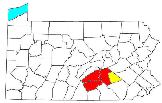
| Description | Locator map of the Harrisburg metro area in the south central part of the U.S. state of Pennsylvania. Red denotes the Harrisburg-Carlisle Metropolitan Statistical Area, and yellow denotes the Lebanon Micropolitan Statistical Area, which is included in the Harrisburg-Carlisle-Lebanon CSA. |
| Date | |
| Source | Modified from this United States Census Bureau file. |
| Author | User:Nyttend |
Licensing[edit]
I, the copyright holder of this work, hereby publish it under the following license:
| I, the copyright holder of this work, release this work into the public domain. This applies worldwide. In some countries this may not be legally possible; if so: I grant anyone the right to use this work for any purpose, without any conditions, unless such conditions are required by law. |
File history
Click on a date/time to view the file as it appeared at that time.
| Date/Time | Thumbnail | Dimensions | User | Comment | |
|---|---|---|---|---|---|
| current | 22:05, 26 July 2008 | | 565 × 361 (28 KB) | Nyttend (talk | contribs) | {{Information |Description=Locator map of the {{w|Harrisburg, Pennsylvania|Harrisburg}} metro area in the south central part of the {{w|U.S. state}} of {{w|Pennsylvania}}. Red denotes the {{w|Harrisburg metropolitan area|Harrisburg-Carlisle Metropolitan |
You cannot overwrite this file.
File usage on Commons
The following page uses this file:
File usage on other wikis
The following other wikis use this file:
- Usage on es.wikipedia.org
- Usage on www.wikidata.org