File:Hammurabi Babilonia CA.svg
Jump to navigation
Jump to search

Size of this PNG preview of this SVG file: 644 × 600 pixels. Other resolutions: 258 × 240 pixels | 515 × 480 pixels | 824 × 768 pixels | 1,099 × 1,024 pixels | 2,198 × 2,048 pixels | 717 × 668 pixels.
Original file (SVG file, nominally 717 × 668 pixels, file size: 169 KB)
Captions
Captions
Add a one-line explanation of what this file represents
Summary[edit]
| Description |
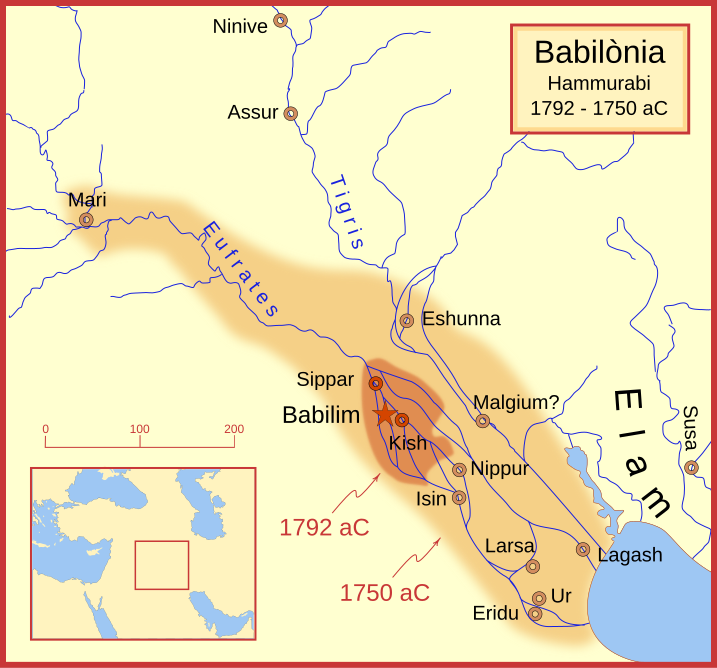
Català: Aquest mapa utilitza els noms que es troben a la Viquipèdia en català per a les ciutats de la Babilònia d'Hammurabi. Mostra el territori babilònic després de la seva ascensió el 1792 aC i després de la seva mort el 1750 aC. Els cursos fluvials i la línia de costa són els d'aquell període de temps; en general, no són els rius o les costes modernes. Es tracta d'una projecció de Mercator, amb el nord en la seva posició habitual.
Hi ha debat fins a quin punt les ciutats de Nínive (Ninive), Tuttul i Assur estaven sota l'autoritat babilònica. Mentre que en la seva introducció al seu codi de lleis, Hammurabi reclama el senyoriu sobre aquestes ciutats, Roaf no n'inclou cap en el seu mapa, en el qual es basa aquest mapa, i Chevalas afirma que "Assur i Nínive es van mantenir durant molt pocs anys." (pàg. 155). Per tant, "no" s'ha inclòs com sota el control d'Hammurabi el 1750 aC.
English: This map uses the names found in the Catalan Wikipedia for the cities of Hammurabi's Babylonia. It shows the Babylonian territory upon his ascension in 1792 BC and upon his death in 1750 BC. The river courses and coastline are those of that time period -- in general, they are not the modern rivers or coastlines. This is a Mercator projection, with north in its usual position.
There is some question to what degree the cities of Nineveh (Ninive), Tuttul, and Assur were under Babylonian authority. While in his introduction to his code of laws, Hammurabi claims lordship over these cities, Roaf does not include any of these in his map, upon which this map is based, and Chevalas states that "Assur and Nineveh were held for a very few years" (p. 155). Therefore, I have not included them as under Hammurabi's control in 1750 BC. |
| Date | |
| Source | Own work |
| Author | MapMaster |
| Other versions |
[]
|


Other versions[edit]
References[edit]
- Bjorklund, Oddvar; Holmboe, Haakon; Rohr, Anders (1970) Historical Atlas of the World, Barnes & Noble, NY, SBN: 389-00253-4.
- Chavalas, Mark W.; K. Lawson Younger (2003) Mesopotamia and the Bible, Continuum International Publishing Group, ISBN 978-0567082312.
- Hammond World Atlas Corporation (2007) Historical World Atlas, ISBN 9-780843-71391-6
- Roaf, M. (1990) Cultural Atlas of Mesopotamia and the ancient Near East, Oxford: Facts on File. (In general, the basis for the ancient river courses and ancient coastline).
- Van De Mieroop, Marc (2005). King Hammurabi of Babylon: A Biography. Blackwell Publishing. ISBN 1405126604
Licensing[edit]
I, the copyright holder of this work, hereby publish it under the following licenses:

|
Permission is granted to copy, distribute and/or modify this document under the terms of the GNU Free Documentation License, Version 1.2 or any later version published by the Free Software Foundation; with no Invariant Sections, no Front-Cover Texts, and no Back-Cover Texts. A copy of the license is included in the section entitled GNU Free Documentation License. |
This file is licensed under the Creative Commons Attribution-Share Alike 4.0 International, 3.0 Unported, 2.5 Generic, 2.0 Generic and 1.0 Generic license.
- You are free:
- to share – to copy, distribute and transmit the work
- to remix – to adapt the work
- Under the following conditions:
- attribution – You must give appropriate credit, provide a link to the license, and indicate if changes were made. You may do so in any reasonable manner, but not in any way that suggests the licensor endorses you or your use.
- share alike – If you remix, transform, or build upon the material, you must distribute your contributions under the same or compatible license as the original.
You may select the license of your choice.
File history
Click on a date/time to view the file as it appeared at that time.
| Date/Time | Thumbnail | Dimensions | User | Comment | |
|---|---|---|---|---|---|
| current | 15:52, 23 February 2008 | | 717 × 668 (169 KB) | MapMaster (talk | contribs) | minor edits |
| 07:15, 23 February 2008 |  | 717 × 668 (169 KB) | MapMaster (talk | contribs) | Changes after seeing the image rendered | |
| 07:05, 23 February 2008 |  | 717 × 668 (167 KB) | MapMaster (talk | contribs) | {{Information |Description=This map uses the names found in the Catalan Wikipedia for the cities of Hammurabi's Babylonia. It shows the Babylonian territory upon his ascension in 1792 BC and upon his death in 1750 BC. The river courses and coastline are |
You cannot overwrite this file.
File usage on Commons
The following 14 pages use this file:
- File:Babilonia de Hammurabi-ES.svg
- File:Hammurabi's Babylonia-he.svg
- File:Hammurabi's Babylonia 1-ar.svg
- File:Hammurabi's Babylonia 1-hu.svg
- File:Hammurabi's Babylonia 1-tr.svg
- File:Hammurabi's Babylonia 1.svg
- File:Hammurabi's Babylonia CS.svg
- File:Hammurabi's Babylonia Locator Map 1.svg
- File:Hammurabi's Babylonia PL.svg
- File:Hammurabi's Babylonia RU.svg
- File:Hammurabi's Babylonia UA.svg
- File:Hammurabi's Babylonia pt.svg
- File:Hammurabi Babilonia CA.svg
- Template:Other versions/Hammurabi's Babylonia 1
File usage on other wikis
The following other wikis use this file:
- Usage on ca.wikipedia.org
- Usage on es.wikipedia.org
- Usage on gl.wikipedia.org
- Usage on no.wikipedia.org
- Usage on oc.wikipedia.org