File:Hamm, Lippeauen -- 2014 -- 8816 crop.jpg
Jump to navigation
Jump to search

Size of this preview: 800 × 549 pixels. Other resolutions: 320 × 220 pixels | 640 × 439 pixels | 1,024 × 703 pixels | 1,280 × 878 pixels | 2,705 × 1,856 pixels.
Original file (2,705 × 1,856 pixels, file size: 4.95 MB, MIME type: image/jpeg)
Captions
Captions
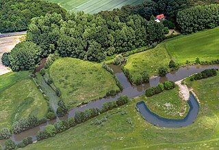
Lippeauen, Hamm and Ahlen, North Rhine-Westphalia, Germany (2014)
Summary[edit]
| Description |
Deutsch: Lippeauen mit ehemaliger Flussschleife „Alte Lippe“ in Hamm und Ahlen, Nordrhein-Westfalen, Deutschland
Die Lippe bildet hier die Gemeindegrenze zwischen den Städten Hamm (südlich des Flusses, unten im Bild) und Ahlen (nördlich, oben im Bild). Die abgebildeten Bereiche der Lippeauen gehören zu den Naturschutzgebieten „Oberwerrieser Mersch“ (NSG HAM-010 in Hamm) und „Lippeaue zwischen Schloss Oberwerries und Dolberg“ (NSG WAF-034 in Ahlen). Die Bundesstraße 61 (Heessener Straße) verläuft oben durchs Bild, in der Ecke oben rechts befindet sich Hof Düpmeier.
|
||||||||||||||||||||||||||||||
| Location | |||||||||||||||||||||||||||||||
| Depicts | landscape – visible features of an area of land | ||||||||||||||||||||||||||||||
| Technical Specifications |
|
||||||||||||||||||||||||||||||
| Image data |
|
||||||||||||||||||||||||||||||
| Date | Taken on 1 June 2014, 13:31 | ||||||||||||||||||||||||||||||
| Source | Own work | ||||||||||||||||||||||||||||||
| Author | Original: Dietmar Rabich (Derivative work: Lämpel) Derivative work Lämpel | ||||||||||||||||||||||||||||||
| Permission (Reusing this file) |
 .svg) I. Licence
This photograph is protected by copyright law. It is a derivative by Lämpel of the original photograph taken by Dietmar Rabich. However, it may be used for free by anyone, provided it is used in accordance with the license Creative Commons License “Attribution-ShareAlike 4.0 International” (CC BY-SA 4.0). These include, among other things, the naming of the author and the license, as well as the setting of a link to the license text or its complete imprint. The attribution has to be done as follows:
Original: Dietmar Rabich (Derivative work: Lämpel) / Wikimedia Commons / /
Please read the text of the license carefully before using the photograph. If you do not agree with the conditions of the license or if you do not understand these conditions, please refrain from using the photo. If you do not comply with the terms of the license, you do not acquire any right to use the image.
For informations about the licence see section Licensing or as human-readable summary or as full licence text at Creative Commons. In addition to the above, a link to the source - so this page with the descriptions and license terms - is appreciated. More information or examples of use can be found at re-use (with example file).
As an alternative to the Creative Commons License CC BY-SA 4.0, the Free Art License (from version 1.3) may also be used.
II. Fairness
From printed materials and other tangible products that use that work, the user is asked to send a copy to the author as thank you. The mailing address can be requested via the contact options.
III. Disclaimer
Please note that the license applies solely for the reuse of the photograph itself. The license doesn't grant you any right regarding the depicted object (eg, copyright or proprietary rights) or the personality rights of the person eventually shown. I do not grant any warranty that the subsequent use of the photograph is legally possible concerning the object or person shown in the photograph. You are responsible to check and respect these rights in the publication in the respective medium or country.
The author is not responsible for the accuracy of the information contained herein (description, title, etc.). Likewise, the author assumes no liability for further use. Please note the general disclaimer and please read reusing content outside Wikimedia too. |
||||||||||||||||||||||||||||||
| Other versions |
|
||||||||||||||||||||||||||||||
| Attribution (required by the license) | Original: Dietmar Rabich (Derivative work: Lämpel) / Wikimedia Commons / /
|
||||||||||||||||||||||||||||||
| Keywords | Aerial view, Ahlen, Architecture, Architektur, Baum, Bauwerk, Bodies of water, Bundesstraße 61, Castle, Deutschland, Einundsechzig, Flora, Fluss, Frühling, Geographie, Germany, Gewässer, Hamm, Heessen, Kreis Warendorf, Kultur, Landscape, Landschaft, Landschaftsfotografie, Licht und Schatten, Luftaufnahme, Luftbild, Münsterland, Natur, Naturschutzgebiet, Nordrhein-Westfalen, North Rhine-Westphalia, Pflanze, Plant, River, Road, Schatten, Schloss, Schloss Oberwerries, Schutzgebiet, Straße, Straßen und Wege, Street, Transport, Tree, Verkehr, Wasser, Westfalen, Wetter, Wolke, Wolkenlandschaftsfotografie, 2014, 61 | ||||||||||||||||||||||||||||||


| Camera location | | View this and other nearby images on: OpenStreetMap |
|---|
|
Location |
The geocoded location of the location of this image is only correct to the nearest 3 km for privacy or other reasons. Please do not improve the accuracy of the coordinates even if you are able to do so. |
|---|
| Dieses Foto entstand aufgrund eines Projektes, das von Wikimedia Deutschland e. V. gefördert wurde.
Im Rahmen des „Community-Projektbudgets“ sollen Luftbilder u. a. vom Münsterland angefertigt werden. Das Projekt „Fotoflüge“ wurde im September 2011 begonnen. Ziel dieses Fotoflugs war das östliche Münsterland. Flüge des Projekts im Münsterland: 12. April 2014 · 1. Juni 2014 · 7. Juni 2014 · 20. Juli 2014 · 1. November 2014 |
Licensing[edit]
Original: Dietmar Rabich (Derivative work: Lämpel), the copyright holder of this work, hereby publishes it under the following license:
This file is licensed under the Creative Commons Attribution-Share Alike 4.0 International license.
Attribution: Original: Dietmar Rabich (Derivative work: Lämpel)
- You are free:
- to share – to copy, distribute and transmit the work
- to remix – to adapt the work
- Under the following conditions:
- attribution – You must give appropriate credit, provide a link to the license, and indicate if changes were made. You may do so in any reasonable manner, but not in any way that suggests the licensor endorses you or your use.
- share alike – If you remix, transform, or build upon the material, you must distribute your contributions under the same or compatible license as the original.
Notes
File history
Click on a date/time to view the file as it appeared at that time.
| Date/Time | Thumbnail | Dimensions | User | Comment | |
|---|---|---|---|---|---|
| current | 12:33, 1 February 2024 | | 2,705 × 1,856 (4.95 MB) | Lämpel (talk | contribs) | {{Information |description = {{de|Lippeauen mit ehemaliger Flussschleife „Alte Lippe“ in Hamm und Ahlen, Nordrhein-Westfalen, Deutschland<br/><small>Die Lippe bildet hier die Gemeindegrenze zwischen den Städten Hamm (südlich des Flusses, unten im Bild) und Ahlen (nördlich, oben im Bild). Die abgebildeten Bereiche der Lippeauen gehören zu den Naturschutzgebieten „Oberwerrieser Mersch“ (NSG HAM-010 in Hamm) und... |
You cannot overwrite this file.
File usage on Commons
The following page uses this file:
File usage on other wikis
The following other wikis use this file:
- Usage on de.wikipedia.org
Metadata
Categories:
- Bundesstraße 61
- Flussbegradigung
- Lippe River
- Naturschutzgebiet Lippeaue zwischen Schloss Oberwerries und Dolberg
- Naturschutzgebiet Oberwerrieser Mersch
- Trees in Hamm
- Channelised rivers and streams in Germany
- Shadows of clouds
- Aerial photographs of Ahlen
- Aerial photographs of Bundesstraßen in Germany
- Aerial photographs of Hamm
- Aerial photographs of rivers of Germany
- 2014 in Ahlen
- 2014 in Hamm
- Spring 2014 in Hamm
- Trees in spring 2014 in North Rhine-Westphalia
- Trees in North Rhine-Westphalia in June