File:Haiti Quake Map.png
Jump to navigation
Jump to search
No higher resolution available.
Haiti_Quake_Map.png (326 × 350 pixels, file size: 26 KB, MIME type: image/png)
Captions
Captions
Add a one-line explanation of what this file represents
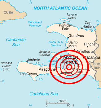
| Description | Map of epicenter of 2010 Haiti Earthquake |
| Date | (UTC) |
| Source | |
| Author |
|
| This is a retouched picture, which means that it has been digitally altered from its original version. The original can be viewed here: Haiti map.png:
|
This image is in the public domain because it contains materials that originally came from the United States Central Intelligence Agency's World Factbook.
|
 |
Original upload log[edit]
This image is a derivative work of the following images:
- File:Haiti_map.png licensed with PD-USGov-CIA-WF
- 2008-11-08T21:49:17Z Nard the Bard 328x352 (11223 Bytes) updating with newest version from CIA world factbook 2008
- 2006-01-29T19:12:47Z Maksim 330x355 (14069 Bytes) La bildo estas kopiita de wikipedia:en. La originala priskribo estas: Map of [[Haiti]]. {{PD-USGov-CIA-WF}} {| border="1" ! date/time || username || edit summary |---- | 23:34, 20 November 2004 || [[:en:User:Neutrality]] |
Uploaded with derivativeFX
File history
Click on a date/time to view the file as it appeared at that time.
| Date/Time | Thumbnail | Dimensions | User | Comment | |
|---|---|---|---|---|---|
| current | 17:07, 15 January 2010 | | 326 × 350 (26 KB) | TUFKAAP (talk | contribs) | The uneveness of the black border bugs me, so I'm removing it. |
| 02:11, 13 January 2010 |  | 328 × 352 (24 KB) | Mahahahaneapneap (talk | contribs) | Compressed | |
| 23:48, 12 January 2010 |  | 328 × 352 (49 KB) | The Weatherman~commonswiki (talk | contribs) | {{Information |Description=Map of 2010 Haiti Earthquake |Source=*File:Haiti_map.png |Date=2010-01-12 23:47 (UTC) |Author=*File:Haiti_map.png: CIA *derivative work: ~~~ |Permission=see below |other_versions= }} {{RetouchedPicture||editor=|orig |
You cannot overwrite this file.
File usage on Commons
The following 3 pages use this file:
File usage on other wikis
The following other wikis use this file:
- Usage on de.wikipedia.org
- Usage on en.wikinews.org
- 7.0 magnitude earthquake strikes off Haitian coast
- Details emerge in Haiti earthquake; thousands feared dead
- Countries around the world send aid, help to Haiti
- Rush Limbaugh and Pat Robertson under fire for remarks about earthquake in Haiti
- Haiti relief efforts: in depth
- Template:2010 Haiti earthquake
- Haitian earthquake: in pictures
- 6.1 magnitude aftershock earthquake hits Haiti
- Haiti rescue effort abandoned
- Haitian minister: Over 150,000 dead in capital after earthquake
- Seven-year-old raises £100,000 for Haiti in sponsored bike ride
- EU to send police officers to Haiti
- Teenage girl pulled out of rubble in Haiti fifteen days after earthquake
- Haiti rescue efforts continue, but survivors face increasing insecurity
- US government stops Haiti evacuations
- US nationals arrested for alleged abduction of Haitian children
- US government to resume Haiti evacuations
- African Union considers proposal to resettle Haitians
- Ten US missionaries charged with child kidnapping in Haiti
- UN reports 222,570 dead in Haiti earthquake
- Quake-hit Haiti struck by Hurricane Tomas
- Usage on es.wikinews.org
- Usage on gl.wikipedia.org
- Usage on ro.wikinews.org
- Usage on ta.wikinews.org
- Usage on www.wikidata.org