File:Hainan Island topographical.jpg
Original file (3,809 × 3,290 pixels, file size: 6.14 MB, MIME type: image/jpeg)
Captions
Captions
Summary[edit]
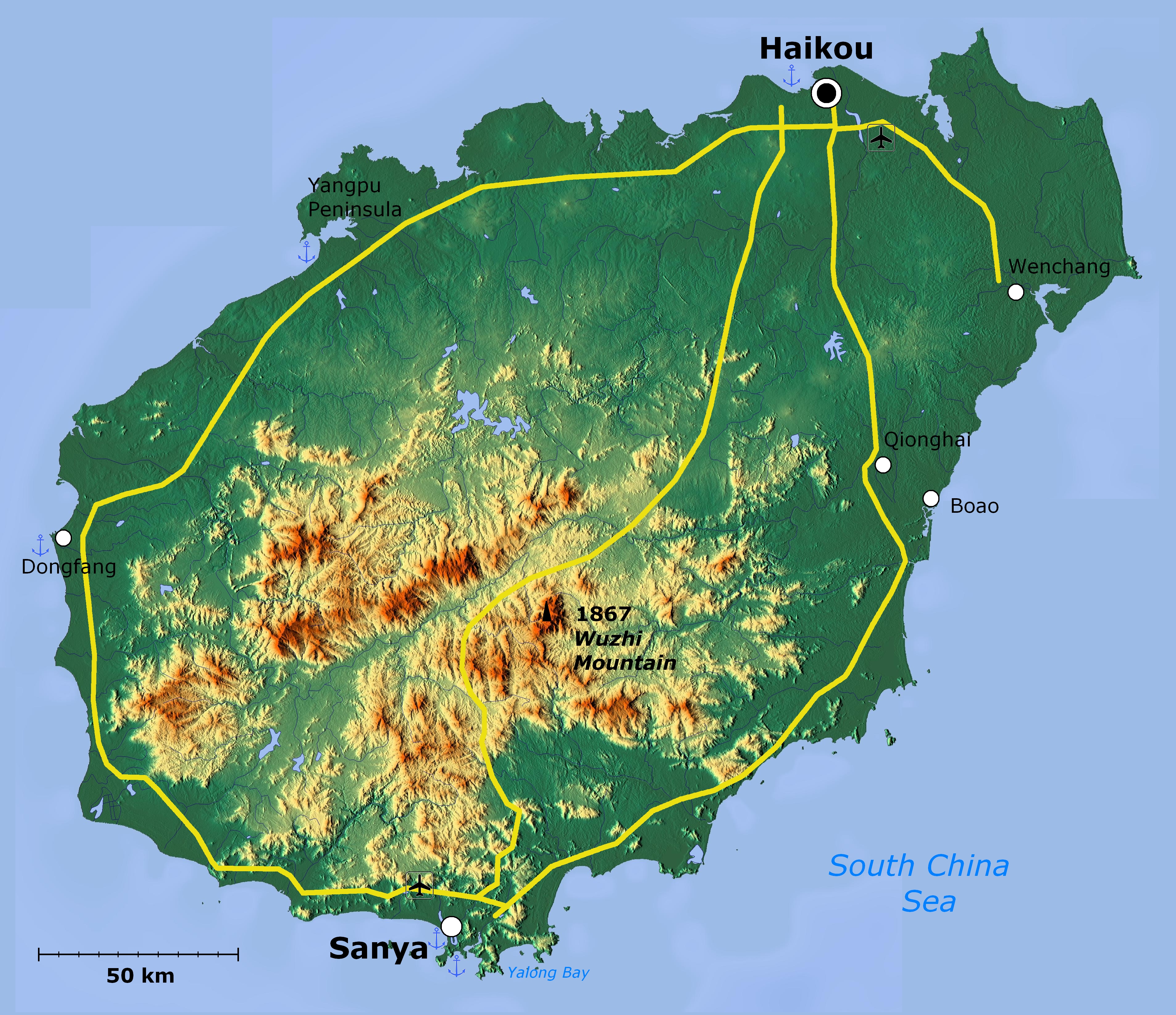
| Description | Topographical map of Hainan Island — in Hainan Province, Southeast China. | ||
| Date | |||
| Source | http://www.maps-for-free.com/ | ||
| Author |
|
||
| Permission (Reusing this file) |
http://www.maps-for-free.com/html/about.html
|
||
| Other versions |

|
This map image could be re-created using vector graphics as an SVG file. This has several advantages; see Commons:Media for cleanup for more information. If an SVG form of this image is available, please upload it and afterwards replace this template with
{{vector version available|new image name}}.
It is recommended to name the SVG file “Hainan Island topographical.svg”—then the template Vector version available (or Vva) does not need the new image name parameter. |


Licensing[edit]
This screenshot either does not contain copyright-eligible parts or visuals of copyrighted software, or the author has released it under a free license (which should be indicated beneath this notice), and as such follows the licensing guidelines for screenshots of Wikimedia Commons. You may use it freely according to its particular license. Free software license:

|
Permission is granted to copy, distribute and/or modify this document under the terms of the GNU Free Documentation License, Version 1.2 or any later version published by the Free Software Foundation; with no Invariant Sections, no Front-Cover Texts, and no Back-Cover Texts. A copy of the license is included in the section entitled GNU Free Documentation License. |
Note: if the screenshot shows any work that is not a direct result of the program code itself, such as a text or graphics that are not part of the program, the license for that work must be indicated separately.
File history
Click on a date/time to view the file as it appeared at that time.
| Date/Time | Thumbnail | Dimensions | User | Comment | |
|---|---|---|---|---|---|
| current | 02:39, 19 April 2011 | | 3,809 × 3,290 (6.14 MB) | Viriditas (talk | contribs) | Upload new version modified by Anna Frodesiak |
| 01:13, 2 April 2011 |  | 3,809 × 3,290 (6.34 MB) | Guerillero (talk | contribs) | {{convert to SVG|map}} {{Information |Description=Hainan Island, China - topographical map |Source=http://www.maps-for-free.com/ |Date=2011-04-02 |Author=Modified by Anna Frodesiak |Permission=http://www.maps-for-free.com/html/about.html |other_versions= |
You cannot overwrite this file.
File usage on Commons
The following page uses this file:
File usage on other wikis
The following other wikis use this file:
- Usage on af.wikipedia.org
- Usage on ar.wikipedia.org
- Usage on az.wikipedia.org
- Usage on be.wikipedia.org
- Usage on en.wikipedia.org
- Usage on et.wikipedia.org
- Usage on fi.wikipedia.org
- Usage on hy.wikipedia.org
- Usage on ja.wikipedia.org
- Usage on mn.wikipedia.org
- Usage on ru.wikipedia.org
- Usage on ru.wiktionary.org
- Usage on vi.wikipedia.org
- Usage on zh-min-nan.wikipedia.org
- Hái-lâm-séng
- Hái-kháu-chhī
- Sam-a-chhī
- Bûn-chhiong-chhī
- Ngó͘-chí-san-chhī
- Sam-soa-chhī
- Tam-chiu-chhī
- Khêng-hái-chhī
- Bān-lêng-chhī
- Tang-hng-chhī
- Tēng-an-koān
- Pang-bô͘:Hái-lâm ê hêng-chèng-khu
- Lîm-ko-koān
- Têng-māi-koān
- Tūn-chhiong-koān
- Chhiong-kang Lê-cho̍k Chū-tī-koān
- Pe̍k-soa Lê-cho̍k Chū-tī-koān
- Khêng-tiong Lê-cho̍k Biâu-cho̍k Chū-tī-koān
- Lêng-chúi Lê-cho̍k Chū-tī-koān
- Pó-têng Lê-cho̍k Biâu-cho̍k Chū-tī-koān
- Lo̍k-tong Lê-cho̍k Chū-tī-koān
- Bí-lân-khu
- Khêng-san-khu
- Liông-hoâ-khu (Hái-kháu)
- Siù-eng-khu
- Kiat-iông-khu
- Hái-tông-khu
- Thian-gâi-khu
- Gâi-chiu-khu
- Usage on zh.wikipedia.org
View more global usage of this file.