File:Hafen von Nizza.jpg
Jump to navigation
Jump to search

Size of this preview: 800 × 394 pixels. Other resolutions: 320 × 158 pixels | 640 × 315 pixels | 1,024 × 505 pixels | 1,280 × 631 pixels | 2,560 × 1,262 pixels | 6,806 × 3,355 pixels.
Original file (6,806 × 3,355 pixels, file size: 14.45 MB, MIME type: image/jpeg)
Captions
Captions
Add a one-line explanation of what this file represents
Summary[edit]
| Description |
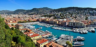
Français : Le port de Nice (Alpes-Maritimes, Provence-Alpes-Côte d’Azur, France), vu de la colline du château.
English: The harbour of Nice (Alpes-Maritimes, Provence-Alpes-Côte d’Azur, France), seen from the hill of the fortress.
Deutsch: Der Hafen von Nizza (Alpes-Maritimes, Provence-Alpes-Côte d’Azur, Frankreich), vom Berg der Zitadelle ausgesehen. |
| Date | |
| Source | Own work |
| Author | Tobi 87 |
| Camera location | | View this and other nearby images on: OpenStreetMap |
|---|

|
This image has been assessed under the valued image criteria and is considered the most valued image on Commons within the scope: Harbour of Nice. You can see its nomination here. |
Licensing[edit]
I, the copyright holder of this work, hereby publish it under the following licenses:

|
Permission is granted to copy, distribute and/or modify this document under the terms of the GNU Free Documentation License, Version 1.2 or any later version published by the Free Software Foundation; with no Invariant Sections, no Front-Cover Texts, and no Back-Cover Texts. A copy of the license is included in the section entitled GNU Free Documentation License. |
This file is licensed under the Creative Commons Attribution-Share Alike 3.0 Unported, 2.5 Generic, 2.0 Generic and 1.0 Generic license.
- You are free:
- to share – to copy, distribute and transmit the work
- to remix – to adapt the work
- Under the following conditions:
- attribution – You must give appropriate credit, provide a link to the license, and indicate if changes were made. You may do so in any reasonable manner, but not in any way that suggests the licensor endorses you or your use.
- share alike – If you remix, transform, or build upon the material, you must distribute your contributions under the same or compatible license as the original.
You may select the license of your choice.
File history
Click on a date/time to view the file as it appeared at that time.
| Date/Time | Thumbnail | Dimensions | User | Comment | |
|---|---|---|---|---|---|
| current | 20:22, 2 October 2011 | | 6,806 × 3,355 (14.45 MB) | Tobi 87 (talk | contribs) | {{Information |Description ={{en|1=harbour of Nice seen from the fortress}} {{de|1=der Hafen von Nizza von der Zitadelle aus gesehen}} {{fr|1=le port de Nice vu de la citadelle}} |Source ={{own}} |Author =Tobi 87 |Date |
You cannot overwrite this file.
File usage on Commons
The following 6 pages use this file:
File usage on other wikis
The following other wikis use this file:
- Usage on de.wikipedia.org
- Usage on de.wikivoyage.org
- Usage on en.wikipedia.org
- Usage on es.wikipedia.org
- Usage on et.wikipedia.org
- Usage on fr.wikipedia.org
- Usage on fr.wikivoyage.org
- Usage on he.wikipedia.org
- Usage on he.wikivoyage.org
- Usage on it.wikipedia.org
- Usage on ko.wikipedia.org
- Usage on lt.wikipedia.org
- Usage on mt.wikipedia.org
- Usage on oc.wikipedia.org
- Usage on pt.wikipedia.org
- Usage on sh.wikipedia.org
- Usage on simple.wikipedia.org
- Usage on th.wikipedia.org
- Usage on tr.wikipedia.org
- Usage on uz.wikipedia.org
- Usage on www.wikidata.org