File:HERE Maps coverage.png
Jump to navigation
Jump to search

Size of this preview: 800 × 428 pixels. Other resolutions: 320 × 171 pixels | 640 × 342 pixels | 1,024 × 548 pixels | 1,436 × 768 pixels.
Original file (1,436 × 768 pixels, file size: 53 KB, MIME type: image/png)
Captions
Captions
Add a one-line explanation of what this file represents
Summary[edit]
| Description |
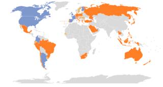
English: HERE Maps street level views coverage with:
partial coverage
full or partial coverage planned
full or partial coverage disputed
no current, planned or disputed coverage |
| Date | |
| Source | Own work |
| Author | Eugen Simion 14 |
Licensing[edit]
I, the copyright holder of this work, hereby publish it under the following license:
| This file is made available under the Creative Commons CC0 1.0 Universal Public Domain Dedication. | |
| The person who associated a work with this deed has dedicated the work to the public domain by waiving all of their rights to the work worldwide under copyright law, including all related and neighboring rights, to the extent allowed by law. You can copy, modify, distribute and perform the work, even for commercial purposes, all without asking permission.
|
File history
Click on a date/time to view the file as it appeared at that time.
| Date/Time | Thumbnail | Dimensions | User | Comment | |
|---|---|---|---|---|---|
| current | 14:27, 12 June 2016 | | 1,436 × 768 (53 KB) | Diretor Adobe (talk | contribs) | Romania - 1 vote in poll |
| 15:15, 10 June 2016 |  | 1,436 × 768 (53 KB) | Diretor Adobe (talk | contribs) | Croatia | |
| 15:14, 10 June 2016 |  | 1,436 × 768 (53 KB) | Diretor Adobe (talk | contribs) | Disputed coverage in poll - http://here.wikia.com/wiki/Here_Wikia#Street_View | |
| 15:11, 10 June 2016 |  | 1,436 × 768 (53 KB) | Diretor Adobe (talk | contribs) | Croatia | |
| 15:10, 10 June 2016 |  | 1,436 × 768 (53 KB) | Diretor Adobe (talk | contribs) | Disputed coverage in poll - http://here.wikia.com/wiki/Here_Wikia#Street_View | |
| 16:10, 14 April 2016 |  | 1,436 × 768 (53 KB) | Eugen Simion 14 (talk | contribs) | can, col | |
| 11:01, 14 April 2016 |  | 1,436 × 768 (53 KB) | Eugen Simion 14 (talk | contribs) | arg | |
| 23:55, 31 March 2016 |  | 1,436 × 768 (53 KB) | The Wormy (talk | contribs) | Hong Kong | |
| 20:03, 20 March 2016 |  | 1,436 × 768 (53 KB) | The Wormy (talk | contribs) | update | |
| 09:39, 17 August 2015 |  | 1,436 × 768 (53 KB) | Eugen Simion 14 (talk | contribs) | up |
You cannot overwrite this file.
File usage on Commons
The following 6 pages use this file:
- User:Chumwa/OgreBot/Travel and communication maps/2016 April 11-20
- User:Chumwa/OgreBot/Travel and communication maps/2016 June 1-10
- User:Chumwa/OgreBot/Travel and communication maps/2016 June 11-20
- User:Chumwa/OgreBot/Travel and communication maps/2016 March 11-20
- User:Chumwa/OgreBot/Travel and communication maps/2016 March 21-31
- File:HERE Maps covarage.png (file redirect)
File usage on other wikis
The following other wikis use this file:
- Usage on en.wikipedia.org
- Usage on pt.wikipedia.org
- Usage on www.wikidata.org
- Usage on zh.wikipedia.org