File:Guizhou Expressway Network Map 2009-2030.jpg
Jump to navigation
Jump to search
Size of this preview: 800 × 599 pixels. Other resolutions: 320 × 239 pixels | 640 × 479 pixels | 1,024 × 766 pixels | 1,280 × 958 pixels | 2,560 × 1,915 pixels | 4,951 × 3,704 pixels.
Original file (4,951 × 3,704 pixels, file size: 7.27 MB, MIME type: image/jpeg)
Captions
Captions
Add a one-line explanation of what this file represents
Summary[edit]
| Description |
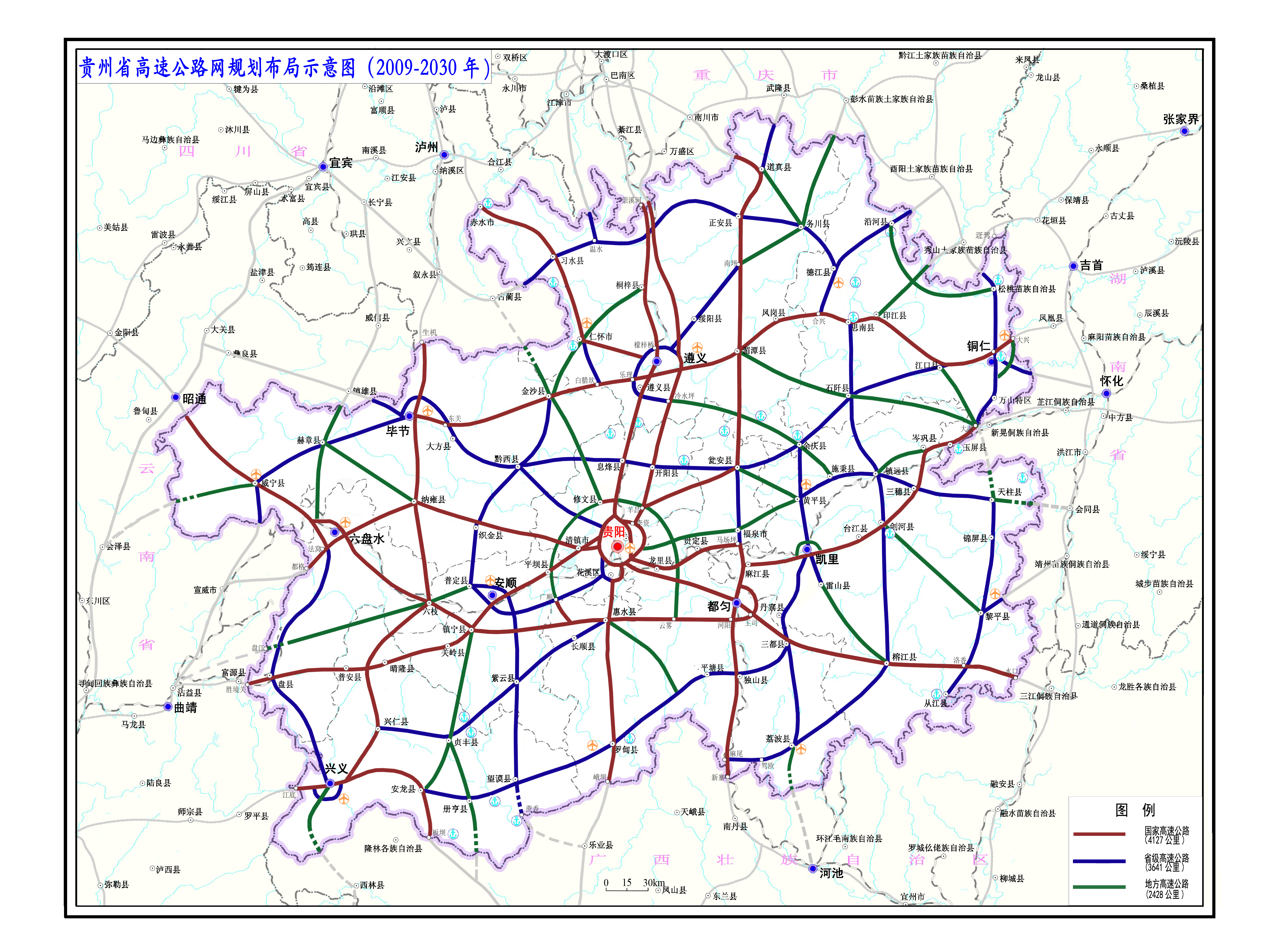
中文:贵州省高速公路网规划布局示意图(2009-2030年) |
| Date | |
| Source | 贵州省高速公路网规划(加密规划) |
| Author | 贵州省交通运输厅 |
Licensing[edit]
Copyright Law of the People's Republic of China: Article 5 This law shall not apply to:
|
 | |
|
This work is from any of the items above and is in the public domain in Mainland China and possibly other jurisdictions. For works whose copyright has expired, see also {{PD-China}} and {{PD-PRC}}. | ||
File history
Click on a date/time to view the file as it appeared at that time.
| Date/Time | Thumbnail | Dimensions | User | Comment | |
|---|---|---|---|---|---|
| current | 18:36, 3 March 2022 | | 4,951 × 3,704 (7.27 MB) | 千里走单骑 (talk | contribs) | Uploaded a work by 贵州省交通运输厅 from [http://jt.guizhou.gov.cn/xxgkml/ztfl/ghjh_16064/zxgh/201701/t20170116_27498154.html 贵州省高速公路网规划] with UploadWizard |
You cannot overwrite this file.
File usage on Commons
The following page uses this file:
File usage on other wikis
The following other wikis use this file:
- Usage on zh.wikipedia.org