File:Guanahani indicated in Juan de la Cosa map from 1500.png
Jump to navigation
Jump to search
No higher resolution available.
Guanahani_indicated_in_Juan_de_la_Cosa_map_from_1500.png (150 × 144 pixels, file size: 38 KB, MIME type: image/png)
Captions
Captions
Add a one-line explanation of what this file represents
Summary[edit]
| Description |
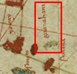
Español: Guanahani (San Salvador - first string of islets discovered by Columbus in 1492) - Label and islets marked within the red box |
| Date | |
| Source | Juan de la Cosa map from 1500 |
| Author | Juan de la Cosa |
Part of the full Juan de la Cosa map: http://en.wikipedia.org/wiki/Map_of_Juan_de_la_Cosa
Licensing[edit]
|
This work is in the public domain in its country of origin and other countries and areas where the copyright term is the author's life plus 100 years or fewer. | |
| This file has been identified as being free of known restrictions under copyright law, including all related and neighboring rights. | |
File history
Click on a date/time to view the file as it appeared at that time.
| Date/Time | Thumbnail | Dimensions | User | Comment | |
|---|---|---|---|---|---|
| current | 00:15, 17 April 2013 | | 150 × 144 (38 KB) | MarkMolander (talk | contribs) | User created page with UploadWizard |
You cannot overwrite this file.
File usage on Commons
There are no pages that use this file.
File usage on other wikis
The following other wikis use this file: