File:Grube Amalienhöhe Dr Geier Förderturm Erzbunker (1).jpg

Original file (3,349 × 2,167 pixels, file size: 968 KB, MIME type: image/jpeg)
Captions
Captions
Summary
[edit].jpg&action=edit§ion=1)
| Description |
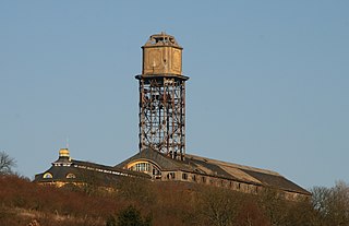
English: Grube Amalienhöhe, Waldalgesheim, Rhineland-Palatinate, Germany
Deutsch: Betriebsgebäude, Förder-/Wasserturm und Erzsilo der Grube Amalienhöhe in Waldalgesheim, Kreis Mainz-Bingen.
Entstanden zwischen 1916 und 1920. Planung und Ausführung durch den Darmstädter Architekten Eugen Seibert. Der in Stahlkonstruktion ausgeführte Förder- und Wasserturm war ursprünglich oberhalb des Silodaches mit einer davorgestellten freitragenden Betonhaut ummantelt. Dabei handelte es sich um ein rein gestalterisches Element, welches sich an der Formensprache von Kirchtürmen orientierte. Seit einem Umbau im Jahr 1963 liegt die Stahlkonstruktion offen. Über dem Förderturm befand sich ein 300.000 Liter fassender Wasserbehälter. Die Eindeckung des Turmes sowie eine abschließende Feuerschale aus Leichtbeton wurden im April 2012 entfernt, der Turm selbst Anfang Januar 2014 umgerissen. Quelle: Klaus Klemp Grube Dr. Geier. Monument des deutschen Erzbergbaus. Verlag im Biebertal, 1987, ISBN 3-9801447-0-4 |
| Date | |
| Source | Own work |
| Author | Marion Halft |
| Object location | | View this and other nearby images on: OpenStreetMap |
|---|
.jpg¶ms=049.958917_N_0007.839056_E_globe:Earth_class:object_type:object_scale:1563_region:DE-RP_&language=en)
Licensing
[edit].jpg&action=edit§ion=2)

|
Permission is granted to copy, distribute and/or modify this document under the terms of the GNU Free Documentation License, Version 1.2 or any later version published by the Free Software Foundation; with no Invariant Sections, no Front-Cover Texts, and no Back-Cover Texts. A copy of the license is included in the section entitled GNU Free Documentation License. |
- You are free:
- to share – to copy, distribute and transmit the work
- to remix – to adapt the work
- Under the following conditions:
- attribution – You must give appropriate credit, provide a link to the license, and indicate if changes were made. You may do so in any reasonable manner, but not in any way that suggests the licensor endorses you or your use.
- share alike – If you remix, transform, or build upon the material, you must distribute your contributions under the same or compatible license as the original.
File history
Click on a date/time to view the file as it appeared at that time.
| Date/Time | Thumbnail | Dimensions | User | Comment | |
|---|---|---|---|---|---|
| current | 08:56, 4 January 2014 | | 3,349 × 2,167 (968 KB) | Haffitt (talk | contribs) | {{Information |Description ={{en|1=Grube Amalienhöhe, Waldalgesheim, Rhineland-Palatinate, Germany}} {{de|1=Betriebsgebäude, Förder-/Wasserturm und Erzsilo der Grube Amalienhöhe in Waldalgesheim... |
You cannot overwrite this file.
File usage on Commons
The following 2 pages use this file:
File usage on other wikis
The following other wikis use this file:
- Usage on de.wikipedia.org
.jpg&oldid=543409668)