File:Greenland Ilulissat-25.jpg
Jump to navigation
Jump to search

Size of this preview: 800 × 519 pixels. Other resolutions: 320 × 208 pixels | 640 × 415 pixels | 1,024 × 664 pixels | 1,280 × 830 pixels.
Original file (1,280 × 830 pixels, file size: 252 KB, MIME type: image/jpeg)
Captions
Captions
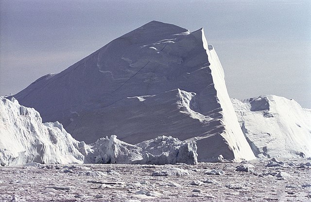
UNESCO heritage site at Kangia Ilulissat Icefjord, on Diskobay at Ilulissiat, Western Greenland
Summary[edit]
| Description |
English: Isfjord, Ilulissat, Diskobay, West Greenland. Huge icebergs (up to 600 ft. high) and calv ice moving out of the Isfjord (Kangia) to the sea. In summer this movement is reaching a speed of 30 m. per day. July 1999, Position: 69° 10´ N, 50° 57´ W |
| Date | |
| Source | Own work |
| Author | Michael Haferkamp |
| Camera location | | View this and other nearby images on: OpenStreetMap |
|---|
Licensing[edit]
I, the copyright holder of this work, hereby publish it under the following licenses:

|
Permission is granted to copy, distribute and/or modify this document under the terms of the GNU Free Documentation License, Version 1.2 or any later version published by the Free Software Foundation; with no Invariant Sections, no Front-Cover Texts, and no Back-Cover Texts. A copy of the license is included in the section entitled GNU Free Documentation License. |
| This file is licensed under the Creative Commons Attribution-Share Alike 3.0 Unported license. | ||
| ||
| This licensing tag was added to this file as part of the GFDL licensing update. |
You may select the license of your choice.
File history
Click on a date/time to view the file as it appeared at that time.
| Date/Time | Thumbnail | Dimensions | User | Comment | |
|---|---|---|---|---|---|
| current | 14:46, 18 June 2005 | | 1,280 × 830 (252 KB) | Michael Haferkamp (talk | contribs) | Isfjord, Ilulissat, Diskobay, West Greenland. Huge icebergs (up to 600 ft. high) and calv ice moving out of the Isfjord (Kangia) to the sea. In summer this movement is reaching a speed of 30 m. per day. July 1999, Position: 69° 10´ N, 50° 57´ W Sour |
You cannot overwrite this file.
File usage on Commons
File usage on other wikis
The following other wikis use this file:
- Usage on bn.wikivoyage.org
- Usage on el.wikivoyage.org
- Usage on en.wikipedia.org
- Usage on en.wikivoyage.org
- Usage on eu.wikipedia.org
- Usage on fa.wikipedia.org
- Usage on fa.wikivoyage.org
- Usage on he.wikivoyage.org
- Usage on id.wikipedia.org
- Usage on ja.wikipedia.org
- Usage on lv.wikipedia.org
- Usage on mai.wikipedia.org
- Usage on mt.wikipedia.org
- Usage on ne.wikipedia.org
- Usage on nl.wikipedia.org
- Usage on pnb.wikipedia.org
- Usage on pt.wikipedia.org
- Usage on sh.wikipedia.org
- Usage on simple.wikipedia.org
- Usage on sr.wikipedia.org
- Usage on sw.wikipedia.org
- Usage on tr.wikipedia.org
- Usage on uk.wikipedia.org
- Usage on ur.wikipedia.org
- Usage on zh.wikipedia.org