File:Greenland Ice.svg
Jump to navigation
Jump to search

Size of this PNG preview of this SVG file: 340 × 599 pixels. Other resolutions: 136 × 240 pixels | 272 × 480 pixels | 436 × 768 pixels | 581 × 1,024 pixels | 1,162 × 2,048 pixels | 399 × 703 pixels.
Original file (SVG file, nominally 399 × 703 pixels, file size: 45 KB)
Captions
Captions
Add a one-line explanation of what this file represents
Summary[edit]
| Description |
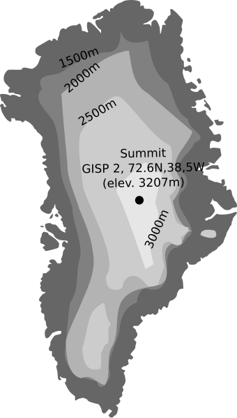
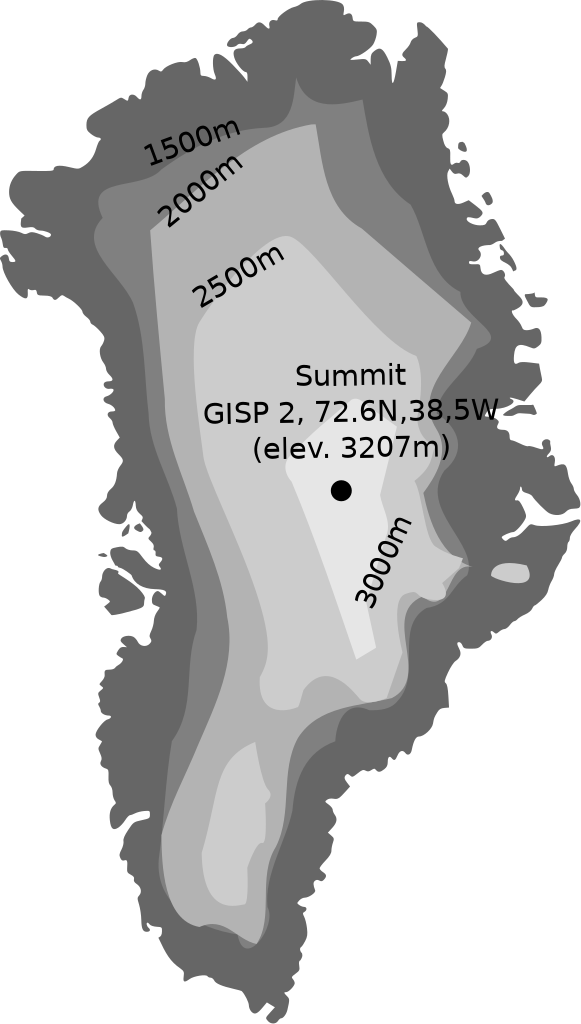
English: A map about the elevation of the ice sheet of Greenland |
| Date | |
| Source | Own work |
| Author | Allstrak |
| Other versions |
|
| SVG development |

Licensing[edit]
I, the copyright holder of this work, hereby publish it under the following licenses:
This file is licensed under the Creative Commons Attribution-Share Alike 3.0 Unported license.
- You are free:
- to share – to copy, distribute and transmit the work
- to remix – to adapt the work
- Under the following conditions:
- attribution – You must give appropriate credit, provide a link to the license, and indicate if changes were made. You may do so in any reasonable manner, but not in any way that suggests the licensor endorses you or your use.
- share alike – If you remix, transform, or build upon the material, you must distribute your contributions under the same or compatible license as the original.

|
Permission is granted to copy, distribute and/or modify this document under the terms of the GNU Free Documentation License, Version 1.2 or any later version published by the Free Software Foundation; with no Invariant Sections, no Front-Cover Texts, and no Back-Cover Texts. A copy of the license is included in the section entitled GNU Free Documentation License. |
You may select the license of your choice.
File history
Click on a date/time to view the file as it appeared at that time.
| Date/Time | Thumbnail | Dimensions | User | Comment | |
|---|---|---|---|---|---|
| current | 12:43, 2 January 2011 | | 399 × 703 (45 KB) | Sting (talk | contribs) | Correction of the southern part's thickness |
| 19:27, 29 April 2009 |  | 399 × 703 (44 KB) | Allstrak (talk | contribs) | image fitted to screen | |
| 18:59, 29 April 2009 |  | 680 × 705 (45 KB) | Allstrak (talk | contribs) | problem fixed | |
| 18:58, 29 April 2009 |  | 680 × 705 (46 KB) | Allstrak (talk | contribs) | {{Information |Description={{en|1=A map about the elevation of the ice shoot of Greenland}} |Source=Own work by uploader |Author=Allstrak |Date=29th April, 2009 |Permission= |other_versions= }} <!--{{ImageUpload|full}}--> [[Category:map |
You cannot overwrite this file.
File usage on Commons
The following page uses this file:
File usage on other wikis
The following other wikis use this file:
- Usage on ca.wikipedia.org
- Usage on da.wikipedia.org
- Usage on da.wikibooks.org
- Usage on de.wikipedia.org
- Usage on es.wikipedia.org
- Usage on fi.wikipedia.org
- Usage on fr.wikipedia.org
- Usage on is.wikipedia.org
- Usage on it.wikipedia.org
- Usage on lt.wikipedia.org
- Usage on oc.wikipedia.org
- Usage on pt.wikipedia.org
- Usage on ru.wikipedia.org
- Usage on uk.wikipedia.org
- Usage on zh.wikipedia.org