File:Greater Manchester County (3).png
Jump to navigation
Jump to search
Size of this preview: 800 × 582 pixels. Other resolutions: 320 × 233 pixels | 640 × 466 pixels | 1,024 × 745 pixels | 1,280 × 931 pixels | 2,560 × 1,862 pixels | 3,358 × 2,443 pixels.
Original file (3,358 × 2,443 pixels, file size: 713 KB, MIME type: image/png)
Captions
Captions
Add a one-line explanation of what this file represents
Summary[edit]
.png&action=edit§ion=1)
| Description |
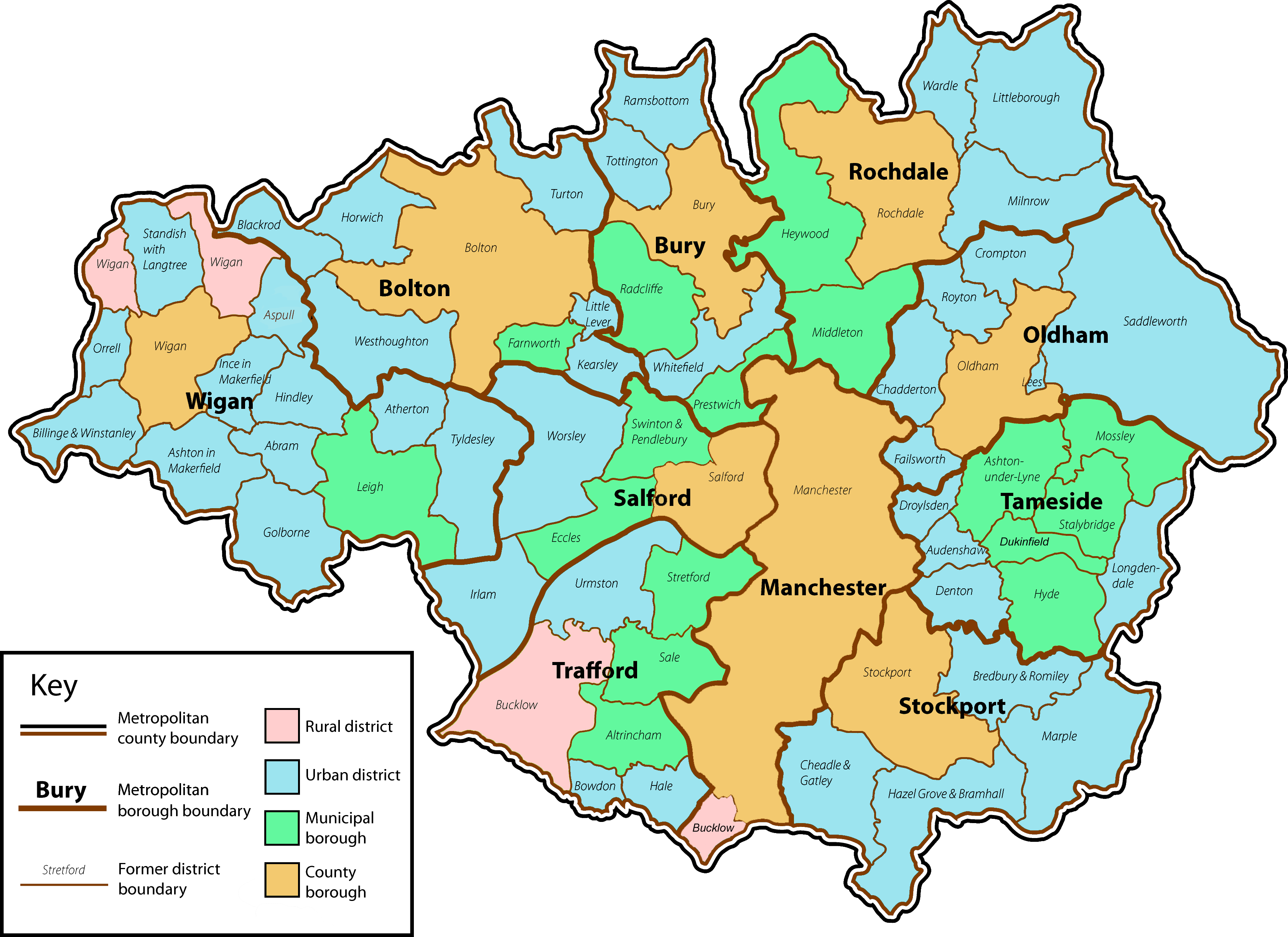
English: A map of the metropolitan county of Greater Manchester with the status of the former local government districts which now lie within its county boundaries. |
| Date | |
| Source | Own work by uploader. Content is verified at Her Majesty's Stationery Office (1974) Local Government in England and Wales: A Guide to the New System, London: HMSO ISBN: 0117508470. |
| Author | Jhamez84 |
| Other versions |
 .png) |
Licensing[edit]
.png&action=edit§ion=2)
| I, the copyright holder of this work, release this work into the public domain. This applies worldwide. In some countries this may not be legally possible; if so: I grant anyone the right to use this work for any purpose, without any conditions, unless such conditions are required by law. |
File history
Click on a date/time to view the file as it appeared at that time.
| Date/Time | Thumbnail | Dimensions | User | Comment | |
|---|---|---|---|---|---|
| current | 02:12, 14 January 2009 | | 3,358 × 2,443 (713 KB) | Jza84 (talk | contribs) | fix Bucklow, Dukinfield and colour of Manchester and Salford. |
| 13:20, 2 July 2008 |  | 3,358 × 2,443 (711 KB) | Jza84 (talk | contribs) | minor cosmetic amendments | |
| 00:22, 2 July 2008 |  | 3,358 × 2,443 (715 KB) | Jza84 (talk | contribs) | fix key | |
| 00:04, 2 July 2008 |  | 3,358 × 2,443 (715 KB) | Jza84 (talk | contribs) | {{Information |Description={{en|1=A map of the metropolitan county of Greater Manchester with the status of the former local government districts which now lie within its county boundaries.}} |Source=Own work by uploader |Author=Jhamez84 |
You cannot overwrite this file.
File usage on Commons
The following 5 pages use this file:
_-_no_key.png)
File usage on other wikis
The following other wikis use this file:
- Usage on ast.wikipedia.org
- Usage on bn.wikipedia.org
- Usage on dag.wikipedia.org
- Usage on en.wikipedia.org
- Greater Manchester
- Greater Manchester County Council
- Civil parishes in Greater Manchester
- Longendale Urban District
- User:Jza84
- Wikipedia talk:WikiProject Greater Manchester/Archive 16
- User:Skinsmoke/Sandbox/Civil parishes/Greater Manchester
- Wikipedia:Graphics Lab/Map workshop/Archive/Dec 2010
- Grade I listed buildings in Greater Manchester
- Usage on es.wikipedia.org
- Usage on fa.wikipedia.org
- Usage on fr.wikipedia.org
- Usage on he.wikipedia.org
- Usage on it.wikipedia.org
- Usage on ru.wikipedia.org
- Usage on zh.wikipedia.org
.png&oldid=475649215)