File:GreaterManchesterNumbered.png
Jump to navigation
Jump to search
No higher resolution available.
GreaterManchesterNumbered.png (200 × 151 pixels, file size: 23 KB, MIME type: image/png)
Captions
Captions
Add a one-line explanation of what this file represents
Summary[edit]

|
File:England Greater Manchester numbered.svg is a vector version of this file. It should be used in place of this PNG file when not inferior.
File:GreaterManchesterNumbered.png → File:England Greater Manchester numbered.svg
For more information, see Help:SVG. |
 |
| Description |
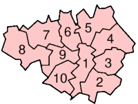
A map of Greater Manchester, with each metropolitan borough numbered. Greater Manchester is a metropolitan county in North West England. The numbers correspond to the following boroughs:
|
| Date | |
| Source | Made by author |
| Author | Morwen |
| Permission (Reusing this file) |
See licencing below |
| Other versions | See Category:Maps of Greater Manchester |
Licensing[edit]

|
Permission is granted to copy, distribute and/or modify this document under the terms of the GNU Free Documentation License, Version 1.2 or any later version published by the Free Software Foundation; with no Invariant Sections, no Front-Cover Texts, and no Back-Cover Texts. A copy of the license is included in the section entitled GNU Free Documentation License. |
| This file is licensed under the Creative Commons Attribution-Share Alike 3.0 Unported license. | ||
| ||
| This licensing tag was added to this file as part of the GFDL licensing update. |
File history
Click on a date/time to view the file as it appeared at that time.
| Date/Time | Thumbnail | Dimensions | User | Comment | |
|---|---|---|---|---|---|
| current | 23:07, 8 July 2008 | | 200 × 151 (23 KB) | Jza84 (talk | contribs) | make background transparent |
| 19:15, 20 February 2006 |  | 200 × 151 (18 KB) | Michiel1972 (talk | contribs) | (del) (cur) 22:45, 21 January 2004 . . Morwen (Talk) . . 200x151 (18681 bytes) (boroughs of Greater Mancehster, all numbered) {{GFDL}} categorie:Maps of England |
You cannot overwrite this file.
File usage on Commons
The following page uses this file:
File usage on other wikis
The following other wikis use this file:
- Usage on bg.wikipedia.org
- Usage on br.wikipedia.org
- Usage on en.wikipedia.org
- Usage on eo.wikipedia.org
- Usage on fa.wikipedia.org
- Usage on gv.wikipedia.org
- Usage on hu.wikipedia.org
- Usage on it.wikipedia.org
- Usage on ja.wikipedia.org
- Usage on ms.wikipedia.org
- Usage on mwl.wikipedia.org
- Usage on nl.wikipedia.org
- Usage on nn.wikipedia.org
- Usage on no.wikipedia.org
- Usage on pl.wikipedia.org
- Usage on pl.wikivoyage.org
- Usage on pt.wikipedia.org
- Usage on ro.wikipedia.org
- Usage on ru.wikipedia.org
- Usage on sk.wikipedia.org
- Usage on tr.wikipedia.org
- Usage on vls.wikipedia.org
- Usage on zh.wikipedia.org