File:Great Lakes North America.jpg
Original file (2,232 × 2,226 pixels, file size: 2.72 MB, MIME type: image/jpeg)
Captions
Captions
Summary[edit]
| Great Lakes, North America | |
|---|---|
| Photographer |
Envisat satellite |
| Title |
Great Lakes, North America |
| Description |
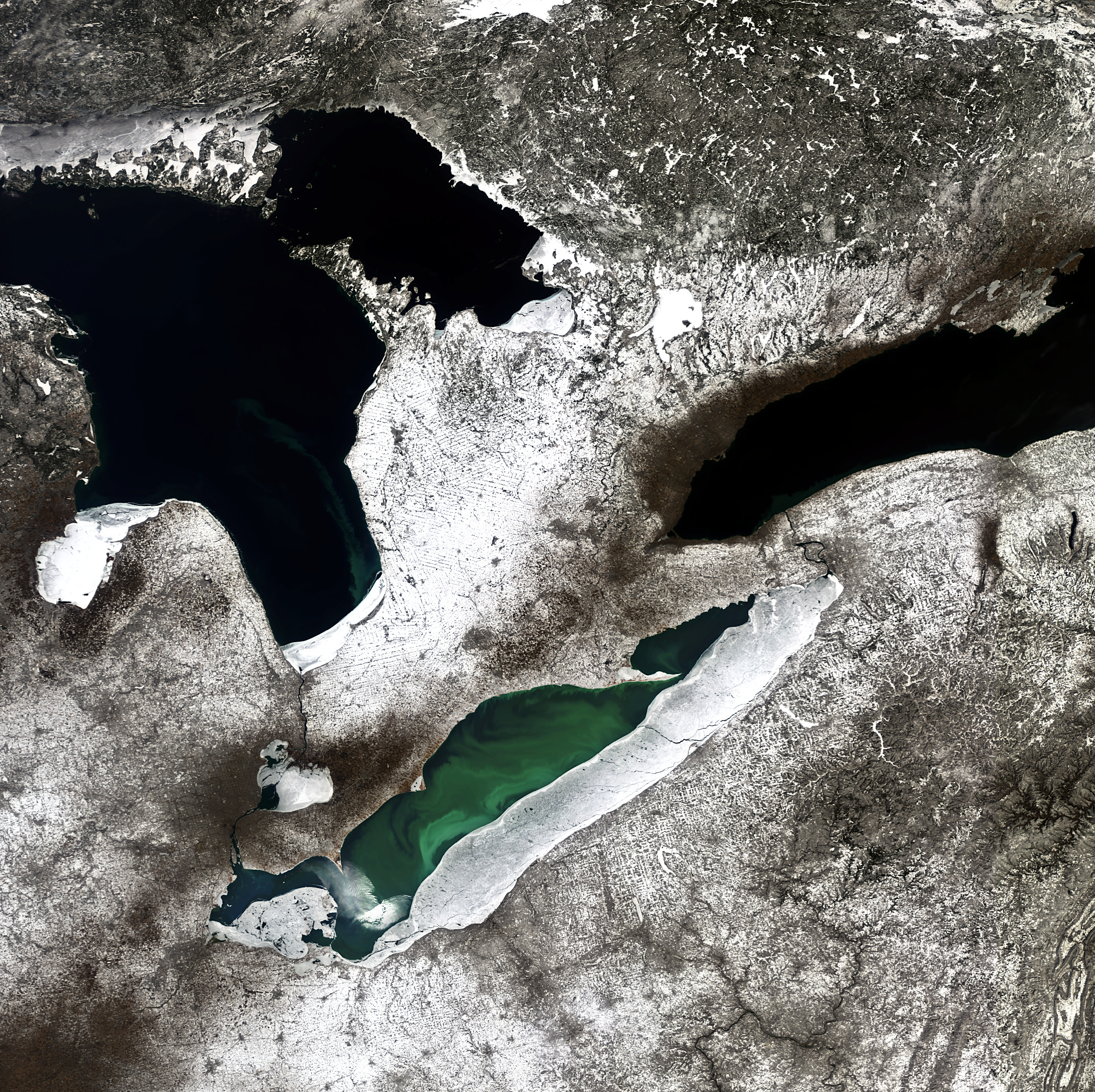
English: Three of North America’s five Great Lakes are pictured in this Envisat image: Lake Huron (left), Lake Ontario (right) and lake Erie (bottom).
About 100 000 years ago, a major ice sheet formed over most of Canada and part of the US. As the ice sheet formed, giant glaciers flowed into the land carving out valleys and levelling mountains. Some 14 000 years ago, higher temperatures began to melt the ice sheet, and meltwater filled the small and large holes left by the glaciers. Many of these holes today still contain water and form the thousands of lakes of the central USA and Canada. The biggest remnants of this process are the Great Lakes. Covering an area of over 244 000 sq km and containing about 22 600 cubic km of water, together the Great Lakes form the largest connected area of fresh, surface water on Earth. The only place where more fresh water is contained is in the polar ice caps. They have played an important role in North America’s economic development by providing a transportation system between the agricultural and mining regions on the western shores with the market centres on the East Coast. The ability to ship materials such as coal, iron and ore also gave rise to the steel and automobile industries in the area. Detroit – nicknamed ‘Motor City’ – is located on the Detroit River (lower left). This image was acquired on 6 March 2010. Snow cover is evident across the land, and we can see ice build-up along some of the lakes’ edges. A green algal bloom is also visible in Lake Erie. These toxic blooms have been a problem for the lake in recent years. Caused by heightened levels of phosphorus – found in fertilisers and common household products – finding its way into the water, these blooms have increased the size of the lake’s low-oxygen 'dead zone'. This image is featured on the Earth from Space video programme. |
| Depicted place | Great Lakes |
| Date | 6 March 2010 |
| Collection | European Space Agency |
| Accession number |
305621 |
| Credit line | ESA |
| Source | http://www.esa.int/spaceinimages/Images/2014/03/Great_Lakes_North_America |
Licensing[edit]
- You are free:
- to share – to copy, distribute and transmit the work
- to remix – to adapt the work
- Under the following conditions:
- attribution – You must give appropriate credit, provide a link to the license, and indicate if changes were made. You may do so in any reasonable manner, but not in any way that suggests the licensor endorses you or your use.
- share alike – If you remix, transform, or build upon the material, you must distribute your contributions under the same or compatible license as the original.
File history
Click on a date/time to view the file as it appeared at that time.
| Date/Time | Thumbnail | Dimensions | User | Comment | |
|---|---|---|---|---|---|
| current | 18:34, 21 February 2017 | | 2,232 × 2,226 (2.72 MB) | Revent (talk | contribs) | full resolution |
| 17:55, 21 February 2017 |  | 1,280 × 1,277 (1,014 KB) | Revent (talk | contribs) | =={{int:filedesc}}== {{Photograph |photographer = Envisat satellite |title = Great Lakes, North America |description = {{en|Three of North America’s five Great Lakes are pictured in this Envisat image: Lake Huron (left),... |
You cannot overwrite this file.
File usage on Commons
The following 2 pages use this file: