File:Great Glen Project Station M - geograph.org.uk - 818230.jpg
Jump to navigation
Jump to search
No higher resolution available.
Great_Glen_Project_Station_M_-_geograph.org.uk_-_818230.jpg (640 × 480 pixels, file size: 27 KB, MIME type: image/jpeg)
Captions
Captions
Add a one-line explanation of what this file represents
Summary[edit]
| Description |
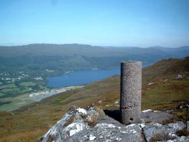
English: Great Glen Project Station M This triangulation pillar was one of around sixteen built for a special survey of the Great Glen in the 1970s. These pillars were not part of the retriangulation of Great Britain and therefore do not appear on any maps. Cylindrical trig pillars were referred to by the OS as 'Vanessa' columns. This pillar has OSBM flush bracket number 11881. The photograph overlooks Fort Augustus and the SW end of Loch Ness. These hills are very rough terrain but the panoramic views are well worth the effort. |
| Date | |
| Source | From geograph.org.uk |
| Author | Graeme Paterson |
| Attribution (required by the license) | Graeme Paterson / Great Glen Project Station M / |
| Camera location | | View this and other nearby images on: OpenStreetMap |
|---|
_heading:0.00&language=en)
| Object location | | View this and other nearby images on: OpenStreetMap |
|---|
_heading:0.00&language=en)
Licensing[edit]

|
This image was taken from the Geograph project collection. See this photograph's page on the Geograph website for the photographer's contact details. The copyright on this image is owned by Graeme Paterson and is licensed for reuse under the Creative Commons Attribution-ShareAlike 2.0 license.
|
This file is licensed under the Creative Commons Attribution-Share Alike 2.0 Generic license.
Attribution: Graeme Paterson
- You are free:
- to share – to copy, distribute and transmit the work
- to remix – to adapt the work
- Under the following conditions:
- attribution – You must give appropriate credit, provide a link to the license, and indicate if changes were made. You may do so in any reasonable manner, but not in any way that suggests the licensor endorses you or your use.
- share alike – If you remix, transform, or build upon the material, you must distribute your contributions under the same or compatible license as the original.
File history
Click on a date/time to view the file as it appeared at that time.
| Date/Time | Thumbnail | Dimensions | User | Comment | |
|---|---|---|---|---|---|
| current | 12:09, 20 February 2011 | | 640 × 480 (27 KB) | GeographBot (talk | contribs) | == {{int:filedesc}} == {{Information |description={{en|1=Great Glen Project Station M This triangulation pillar was one of around sixteen built for a special survey of the Great Glen in the 1970s. These pillars were not part of the retriangulation of Grea |
You cannot overwrite this file.
File usage on Commons
The following 2 pages use this file:
File usage on other wikis
The following other wikis use this file:
- Usage on cs.wikipedia.org
- Usage on en.wikipedia.org
- Usage on eu.wikipedia.org
- Usage on ga.wikipedia.org
- Usage on ja.wikipedia.org
- Usage on sl.wikipedia.org
- Usage on www.wikidata.org