File:Great Fire of London Map.png
Jump to navigation
Jump to search

Size of this preview: 800 × 471 pixels. Other resolutions: 320 × 188 pixels | 640 × 376 pixels | 1,024 × 602 pixels | 1,280 × 753 pixels | 2,550 × 1,500 pixels.
Original file (2,550 × 1,500 pixels, file size: 342 KB, MIME type: image/png)
Captions
Captions
Add a one-line explanation of what this file represents

|
This city map image could be re-created using vector graphics as an SVG file. This has several advantages; see Commons:Media for cleanup for more information. If an SVG form of this image is available, please upload it and afterwards replace this template with
{{vector version available|new image name}}.
It is recommended to name the SVG file “Great Fire of London Map.svg”—then the template Vector version available (or Vva) does not need the new image name parameter. |
Summary[edit]
| Description |
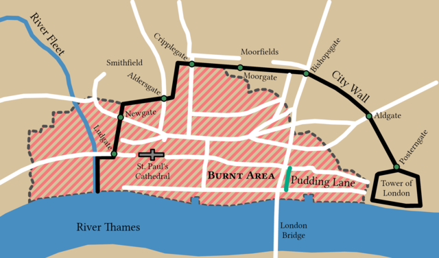
English: Spread of the Great Fire of London based on Tinniswood (2003, p. 97) and Hollar (1666). This map is a part of a remake of a mapseries made by Bunchofgrapes in 2006 to fix accessability issues. The orignal map was traced in ArcGIS Pro to produce this one and with consulation from reliable sources. |
||
| Date | |||
| Source |
This file was derived from: Great fire of london map.png: |
||
| Creator |
|
||
| Credit line | © Bunchofgrapes and Tom Fish // Creative Commons CC BY-SA 3.0 | ||
| Permission (Reusing this file) |
|
||
| Georeferencing | |||
| Archival data | |||
| artwork-references |
|
||
| PNG development | This map was created with ArcGIS Pro. |
||
Licensing[edit]
This file is licensed under the Creative Commons Attribution-Share Alike 3.0 Unported license.
- You are free:
- to share – to copy, distribute and transmit the work
- to remix – to adapt the work
- Under the following conditions:
- attribution – You must give appropriate credit, provide a link to the license, and indicate if changes were made. You may do so in any reasonable manner, but not in any way that suggests the licensor endorses you or your use.
- share alike – If you remix, transform, or build upon the material, you must distribute your contributions under the same or compatible license as the original.
File history
Click on a date/time to view the file as it appeared at that time.
| Date/Time | Thumbnail | Dimensions | User | Comment | |
|---|---|---|---|---|---|
| current | 11:52, 6 June 2022 | | 2,550 × 1,500 (342 KB) | Guerillero (talk | contribs) | Fix small issues |
| 15:33, 30 December 2021 |  | 2,125 × 1,250 (282 KB) | Guerillero (talk | contribs) | == {{int:filedesc}} == {{User:Guerillero/Template |Description= {{en|Spread of the Great Fire of London}} |Source={{Derived from|Great fire of london map.png|display=50}} |Author={{u|Bunchofgrapes}} |Date= 29 December 2021 }} == {{int:license-header}} == {{Cc-by-sa-3.0}} Category:Maps of the Great Fire of London |
You cannot overwrite this file.
File usage on Commons
The following page uses this file:
File usage on other wikis
The following other wikis use this file:
- Usage on azb.wikipedia.org
- Usage on en.wikipedia.org
- Usage on lv.wikipedia.org
- Usage on pt.wikipedia.org
- Usage on sl.wikipedia.org