File:Great Britain Hausdorff.svg
Jump to navigation
Jump to search

Size of this PNG preview of this SVG file: 512 × 296 pixels. Other resolutions: 320 × 185 pixels | 640 × 370 pixels | 1,024 × 592 pixels | 1,280 × 740 pixels | 2,560 × 1,480 pixels.
Original file (SVG file, nominally 512 × 296 pixels, file size: 126 KB)
Captions
Captions
Add a one-line explanation of what this file represents
Summary[edit]
| Description |
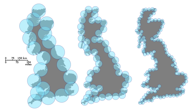
English: Fractal dimension : Covering of a fractal set (here, the coast of Great Britain) by balls of decreasing size.
Français : Dimension fractale : Couverture d'une fractale (ici, la côte de la Grande-Bretagne) par des boules de taille décroissante. |
| Date | |
| Source | Own work |
| Author | Prokofiev |
| Other versions |
  |
Licensing[edit]
I, the copyright holder of this work, hereby publish it under the following licenses:
This file is licensed under the Creative Commons Attribution-Share Alike 3.0 Unported license.
- You are free:
- to share – to copy, distribute and transmit the work
- to remix – to adapt the work
- Under the following conditions:
- attribution – You must give appropriate credit, provide a link to the license, and indicate if changes were made. You may do so in any reasonable manner, but not in any way that suggests the licensor endorses you or your use.
- share alike – If you remix, transform, or build upon the material, you must distribute your contributions under the same or compatible license as the original.

|
Permission is granted to copy, distribute and/or modify this document under the terms of the GNU Free Documentation License, Version 1.2 or any later version published by the Free Software Foundation; with no Invariant Sections, no Front-Cover Texts, and no Back-Cover Texts. A copy of the license is included in the section entitled GNU Free Documentation License. |
You may select the license of your choice.
File history
Click on a date/time to view the file as it appeared at that time.
| Date/Time | Thumbnail | Dimensions | User | Comment | |
|---|---|---|---|---|---|
| current | 20:57, 21 January 2014 | | 512 × 296 (126 KB) | Jeanacoa (talk | contribs) | Great Britain maps cloned and code optimized with Inkscape |
| 16:24, 13 November 2010 |  | 3,000 × 1,732 (393 KB) | Prokofiev (talk | contribs) | Better quality. | |
| 15:52, 13 November 2010 |  | 3,000 × 1,732 (393 KB) | Prokofiev (talk | contribs) | Oups. wrong frame. | |
| 15:48, 13 November 2010 |  | 3,000 × 1,732 (384 KB) | Prokofiev (talk | contribs) | {{Information |Description={{en|1=Fractal dimension : Measuring the Hausdorff-Besocovitch dimension of the coast of Great Britain. We find the best way to cover the coast with disks of equal size. }} |Source={{own}} |Author=Prokofiev |D |
You cannot overwrite this file.
File usage on Commons
The following 3 pages use this file:
File usage on other wikis
The following other wikis use this file:
- Usage on ar.wikipedia.org
- Usage on ca.wikipedia.org
- Usage on el.wikipedia.org
- Usage on en.wikipedia.org
- Usage on es.wikipedia.org
- Usage on fr.wikipedia.org
- Usage on he.wikipedia.org
- Usage on ja.wikipedia.org
- Usage on ko.wikipedia.org
- Usage on vi.wikipedia.org