File:Grant county kansas map 1905 MSTR.png
Jump to navigation
Jump to search
Size of this preview: 463 × 599 pixels. Other resolutions: 185 × 240 pixels | 560 × 725 pixels.
Original file (560 × 725 pixels, file size: 97 KB, MIME type: image/png)
Captions
Captions
Add a one-line explanation of what this file represents
Summary[edit]
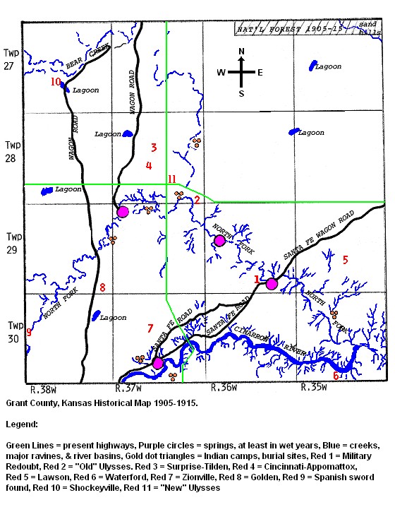
| Description | Grant County Kansas Historical Map 1905-1915 |
| Date | |
| Source | Own work |
| Author | K0dpw |
Licensing[edit]
I, the copyright holder of this work, hereby publish it under the following license:
This file is licensed under the Creative Commons Attribution 3.0 Unported license.
- You are free:
- to share – to copy, distribute and transmit the work
- to remix – to adapt the work
- Under the following conditions:
- attribution – You must give appropriate credit, provide a link to the license, and indicate if changes were made. You may do so in any reasonable manner, but not in any way that suggests the licensor endorses you or your use.

File history
Click on a date/time to view the file as it appeared at that time.
| Date/Time | Thumbnail | Dimensions | User | Comment | |
|---|---|---|---|---|---|
| current | 00:47, 1 March 2012 | | 560 × 725 (97 KB) | K0dpw (talk | contribs) | Add legend into image, plus document location of "New" Ulysses |
| 22:18, 29 February 2012 |  | 560 × 560 (87 KB) | K0dpw (talk | contribs) | {{Information |Description=Grant County Kansas Historical Map 1905-1915 |Source={{own}} |Date=2012-02-29 |Author= K0dpw |Permission= |other_versions= }} |
You cannot overwrite this file.
File usage on Commons
There are no pages that use this file.
File usage on other wikis
The following other wikis use this file:
- Usage on en.wikipedia.org
- Usage on ja.wikipedia.org
- Usage on simple.wikipedia.org