File:Grésignac Motte castrale 2012.jpg
Jump to navigation
Jump to search

Size of this preview: 800 × 202 pixels. Other resolutions: 320 × 81 pixels | 640 × 162 pixels | 1,024 × 259 pixels | 1,280 × 323 pixels | 2,560 × 647 pixels | 8,552 × 2,160 pixels.
Original file (8,552 × 2,160 pixels, file size: 3.73 MB, MIME type: image/jpeg)
Captions
Captions
Add a one-line explanation of what this file represents
Summary[edit]
| Description |
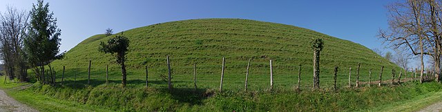
Français : Motte castrale de Grésignac, citée dès 1243 sous le nom de "Castrum de Greziniaco". Grésignac, Dordogne, France.
English: Former motte-and-bailey castle attested as "Castrum de Greziniaco" from 1243. Grésignac, Dordogne, France.
|
|
| Date | ||
| Source | Own work | |
| Author | ||
| Attribution (required by the license) | Photo: JLPC / Wikimedia Commons / | |
| Permission (Reusing this file) |
I, the copyright holder of this work, hereby publish it under the following license: This file is licensed under the Creative Commons Attribution-Share Alike 3.0 Unported license.
|
| Camera location | | View this and other nearby images on: OpenStreetMap |
|---|

|
NOTE: This image is a panorama consisting of 4 frames that were merged or stitched in hugin. As a result, this image necessarily underwent some form of digital manipulation. These manipulations may include blending, blurring, cloning, and colour and perspective adjustments. As a result of these adjustments, the image content may be slightly different from reality at the points where multiple images were combined. This manipulation is often required due to lens, perspective, and parallax distortions.
|
Licensing[edit]
I, the copyright holder of this work, hereby publish it under the following license:
This file is licensed under the Creative Commons Attribution-Share Alike 3.0 Unported license.
- You are free:
- to share – to copy, distribute and transmit the work
- to remix – to adapt the work
- Under the following conditions:
- attribution – You must give appropriate credit, provide a link to the license, and indicate if changes were made. You may do so in any reasonable manner, but not in any way that suggests the licensor endorses you or your use.
- share alike – If you remix, transform, or build upon the material, you must distribute your contributions under the same or compatible license as the original.
File history
Click on a date/time to view the file as it appeared at that time.
| Date/Time | Thumbnail | Dimensions | User | Comment | |
|---|---|---|---|---|---|
| current | 13:41, 7 April 2012 | 8,552 × 2,160 (3.73 MB) | JLPC (talk | contribs) |
You cannot overwrite this file.
File usage on Commons
The following 2 pages use this file:
File usage on other wikis
The following other wikis use this file:
- Usage on de.wikipedia.org
- Usage on fr.wikipedia.org