File:Golan heights rel89-orig.jpg
Jump to navigation
Jump to search

Size of this preview: 474 × 599 pixels. Other resolutions: 190 × 240 pixels | 380 × 480 pixels | 974 × 1,231 pixels.
Original file (974 × 1,231 pixels, file size: 245 KB, MIME type: image/jpeg)
Captions
Captions
Add a one-line explanation of what this file represents
| Description |
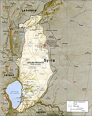
English: CIA map of the Golan Heights showing Israeli settlements and Syrian villages as of 1989 |
|||
| Date | ||||
| Source | http://www.lib.utexas.edu/maps/middle_east_and_asia/golan_heights_rel89.jpg | |||
| Author | CIA | |||
| Permission (Reusing this file) |
|

File history
Click on a date/time to view the file as it appeared at that time.
| Date/Time | Thumbnail | Dimensions | User | Comment | |
|---|---|---|---|---|---|
| current | 15:15, 7 July 2009 | | 974 × 1,231 (245 KB) | Nableezy (talk | contribs) | {{Information |Description={{en|1=CIA map of the Golan Height showing Israeli settlements and Syrian villages as of 1989}} |Source=http://www.lib.utexas.edu/maps/middle_east_and_asia/golan_heights_rel89.jpg |Author=CIA |Date=1989 |Permission={{PD-USGov-CI |
You cannot overwrite this file.
File usage on Commons
The following page uses this file:
File usage on other wikis
The following other wikis use this file:
- Usage on ar.wikipedia.org
- Usage on arz.wikipedia.org
- Usage on be-tarask.wikipedia.org
- Usage on bg.wikipedia.org
- Usage on ca.wikipedia.org
- Usage on csb.wikipedia.org
- Usage on cs.wikipedia.org
- Usage on da.wikipedia.org
- Usage on en.wikipedia.org
- Usage on es.wikipedia.org
- Usage on fy.wikipedia.org
- Usage on hi.wikipedia.org
- Usage on hy.wikipedia.org
- Usage on id.wikipedia.org
- Usage on incubator.wikimedia.org
- Usage on it.wikipedia.org
- Usage on ka.wikipedia.org
- Usage on lt.wikipedia.org
- Usage on ms.wikipedia.org
- Usage on nl.wikipedia.org
- Usage on nn.wikipedia.org
- Usage on no.wikipedia.org
- Usage on pl.wikipedia.org
- Usage on pnb.wikipedia.org
- Usage on pt.wikibooks.org
- Usage on ru.wikipedia.org
- Usage on uk.wikipedia.org
- Usage on vi.wikipedia.org
- Usage on www.wikidata.org
- Usage on xmf.wikipedia.org
- Usage on zh.wikipedia.org