File:Global carbon dioxide AIRS.jpg
Jump to navigation
Jump to search
No higher resolution available.
Global_carbon_dioxide_AIRS.jpg (496 × 392 pixels, file size: 28 KB, MIME type: image/jpeg)
Captions
Captions
Add a one-line explanation of what this file represents
Summary[edit]
| Description |
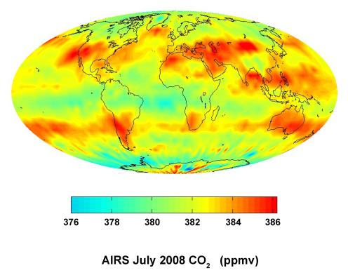
English: This global satellite map shows carbon dioxide in the mid-troposphere, about 8 kilometers above Earth. It was created with data acquired by the Atmospheric Infrared Sounder (AIRS) instrument during July 2008.
The distribution of carbon dioxide in this region of the atmosphere is strongly influenced by major surface sources of carbon dioxide and by large-scale atmospheric circulation patterns, such as the jet streams and weather systems in Earth's mid-latitudes. Patterns of carbon dioxide distribution differ significantly between the northern hemisphere, with its many land masses, and the southern hemisphere, which is largely covered by ocean. AIRS is one of six instruments flying on NASA's Aqua satellite. English: Carte satellitale mondiale montrant le taux moyen de dioxyde de carbone dans la mi-troposphère (+/-8 kilomètres au-dessus du niveau de la mer). Sa distribution à cette altitude est encore très influencée par les sources de surface mais elle subit aussi les grands courants de circulation atmosphérique (jets et systèmes météorologiques actifs aux latitudes moyennes de la Terre). Les schémas de distribution du CO2 diffèrent considérablement entre l'hémisphère nord, avec ses nombreuses masses terrestres très anthropisées, et l'hémisphère sud, plus largement recouvert par l'océan. Données acquises par l'instrument Atmospheric Infrared Sounder (AIRS) en juillet 2008 ; AIRS est l'un des six instruments embarqués sur le satellite Aqua de la NASA |
| Date | |
| Source | http://photojournal.jpl.nasa.gov/catalog/PIA11194 |
| Author | NASA/JPL |
This image or video was catalogued by Jet Propulsion Laboratory of the United States National Aeronautics and Space Administration (NASA) under Photo ID: PIA11194. This tag does not indicate the copyright status of the attached work. A normal copyright tag is still required. See Commons:Licensing. Other languages:
|


Licensing[edit]
| This file is in the public domain in the United States because it was solely created by NASA. NASA copyright policy states that "NASA material is not protected by copyright unless noted". (See Template:PD-USGov, NASA copyright policy page or JPL Image Use Policy.) | ||
 |
Warnings:
|
File history
Click on a date/time to view the file as it appeared at that time.
| Date/Time | Thumbnail | Dimensions | User | Comment | |
|---|---|---|---|---|---|
| current | 21:23, 9 March 2012 | | 496 × 392 (28 KB) | Ras67 (talk | contribs) | losslessly cropped with Jpegcrop |
| 17:16, 25 October 2008 |  | 666 × 500 (31 KB) | Maddox1 (talk | contribs) | {{Information |Description={{en|1=This global satellite map shows carbon dioxide in the mid-troposphere, about 8 kilometers above Earth. It was created with data acquired by the Atmospheric Infrared Sounder (AIRS) instrument during July 2008. The di |
You cannot overwrite this file.
File usage on Commons
There are no pages that use this file.
File usage on other wikis
The following other wikis use this file:
- Usage on ar.wikipedia.org
- Usage on de.wikipedia.org
- Usage on de.wikiversity.org
- Usage on en.wikipedia.org
- Usage on en.wikibooks.org
- Usage on fr.wikipedia.org
- Usage on fr.wikiversity.org
- Usage on no.wikipedia.org
- Usage on vi.wikipedia.org