File:Glacier Bay, Alaska ESA24313468.jpeg

Original file (14,571 × 8,196 pixels, file size: 15.33 MB, MIME type: image/jpeg)
Captions
Captions
Summary[edit]
| Warning | The original file is very high-resolution. It might not load properly or could cause your browser to freeze when opened at full size. |
|---|
| Description |
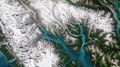
English: Part of the Glacier Bay National Park and Preserve, which lies along the coast of southeast Alaska, is featured in this image captured by the Copernicus Sentinel-2 mission. Zoom in to see this image at its full 10 m resolution or click on the circles to learn more about the features in it. Covering over 13 000 sq km of rugged, snow-capped mountains, freshwater lakes, glaciers and deep fjords, Glacier Bay National Park and Preserve is one of the highlights of Alaska’s Inside Passage. As marine waters make up almost one-fifth of the park, Glacier Bay is rich with marine life, including humpback whales, orcas and sea otters. It’s also home to a large population of bears, moose, wolves and mountain goats. The bay contains some of the world’s most impressive glaciers that descend from the ice-covered St. Elias Range in the east and the Fairweather Range in the west, with a few notable tidewater glaciers extending all the way to the sea. John Hopkins Glacier, visible in the far left of the image, is the largest tidewater glacier in the region. Muir Glacier, formerly the most famous of the tidewater glaciers, once rose around 80 m above water and was nearly 3 km wide but has now shrunk and receded and no longer reaches the sea. Glacier Bay is just one of the many areas suffering from the effects of global warming. The bay is expected to become warmer and drier over the next century, with widespread effects including the further shrinking glaciers, reduced sea ice and shoreline erosion. Monitoring glaciers is often a challenge considering their sheer size, remoteness and rugged terrain they occupy. Satellites, including ESA’s CryoSat mission, with its elite spaceborne sensor – the radar altimeter – allows for the mapping of glaciers in fine detail. In a study published last year in the Cryosphere, scientists utilised data from the CryoSat mission to show how much ice had been lost from mountain glaciers in the Gulf of Alaska. Today marks the opening of the ‘Earth’s Memory - glaciers witnesses to the climate crisis’ exhibition, that follows the scientific and photographic journey of glaciers around the world, premiering the results of the ‘On the trail of the glaciers’ project directed by Italian photographer Fabiano Ventura. The exhibition, which is being held in the Forte di Bard Museum, Aosta Valley, Italy, offers its visitors the opportunity to witness the effects of global warming through the power of both photography and ESA satellite imagery. The exhibition focuses on the world’s largest mountain glaciers with 90 photographic comparisons displayed alongside scientific data collected during the team’s expedition to the world’s largest mountain glaciers. It runs until 18 November 2022 and includes images such as the one featured on this week’s Earth from Space programme. More information on the exhibition, which is part of a scientific collaboration between ESA and is sponsored by UNESCO, can be found here. This image is also featured on the Earth from Space video programme. |
| Date | 17 June 2022 (upload date) |
| Source | Glacier Bay, Alaska |
| Author | European Space Agency |
| Other versions |
|
| Activity | Observing the Earth |
| Mission | Sentinel-2 |
| Set | Earth observation image of the week |
| System | Copernicus |
Licensing[edit]

|
This image contains data from a satellite in the Copernicus Programme, such as Sentinel-1, Sentinel-2 or Sentinel-3. Attribution is required when using this image.
Attribution: Contains modified Copernicus Sentinel data 2021
The use of Copernicus Sentinel Data is regulated under EU law (Commission Delegated Regulation (EU) No 1159/2013 and Regulation (EU) No 377/2014). Relevant excerpts:
Free access shall be given to GMES dedicated data [...] made available through GMES dissemination platforms [...].
Access to GMES dedicated data [...] shall be given for the purpose of the following use in so far as it is lawful:
GMES dedicated data [...] may be used worldwide without limitations in time.
GMES dedicated data and GMES service information are provided to users without any express or implied warranty, including as regards quality and suitability for any purpose. |
This media was created by the European Space Agency (ESA).
Where expressly so stated, images or videos are covered by the Creative Commons Attribution-ShareAlike 3.0 IGO (CC BY-SA 3.0 IGO) licence, ESA being an Intergovernmental Organisation (IGO), as defined by the CC BY-SA 3.0 IGO licence. The user is allowed under the terms and conditions of the CC BY-SA 3.0 IGO license to Reproduce, Distribute and Publicly Perform the ESA images and videos released under CC BY-SA 3.0 IGO licence and the Adaptations thereof, without further explicit permission being necessary, for as long as the user complies with the conditions and restrictions set forth in the CC BY-SA 3.0 IGO licence, these including that:
See the ESA Creative Commons copyright notice for complete information, and this article for additional details.
|
 | |
This file is licensed under the Creative Commons Attribution-ShareAlike 3.0 IGO license. Attribution: ESA, CC BY-SA IGO 3.0
| ||
File history
Click on a date/time to view the file as it appeared at that time.
| Date/Time | Thumbnail | Dimensions | User | Comment | |
|---|---|---|---|---|---|
| current | 09:35, 17 June 2022 | | 14,571 × 8,196 (15.33 MB) | OptimusPrimeBot (talk | contribs) | #Spacemedia - Upload of https://www.esa.int/var/esa/storage/images/esa_multimedia/images/2022/06/glacier_bay_alaska/24313458-1-eng-GB/Glacier_Bay_Alaska.jpg via Commons:Spacemedia |
You cannot overwrite this file.
File usage on Commons
The following page uses this file: