File:Ghajar highlighted.JPG
Jump to navigation
Jump to search
Size of this preview: 517 × 599 pixels. Other resolutions: 207 × 240 pixels | 414 × 480 pixels | 742 × 860 pixels.
Original file (742 × 860 pixels, file size: 108 KB, MIME type: image/jpeg)
Captions
Captions
Add a one-line explanation of what this file represents
| Description |
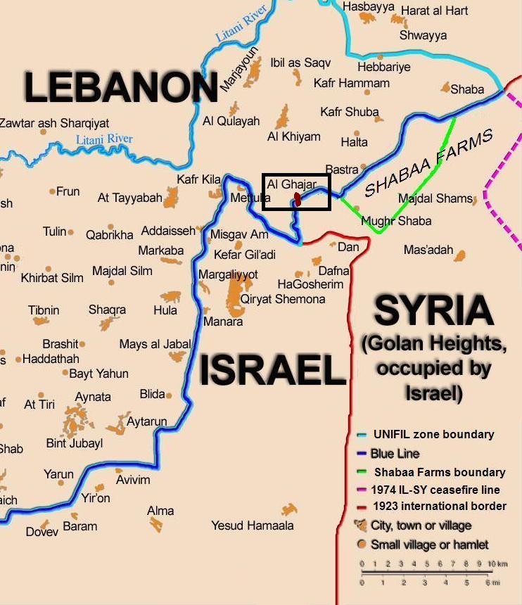
English: Map showing the Blue Line demarcation line between Lebanon and Israel, established by the UN after the Israeli withdrawal from southern Lebanon after its short 1978 invasion called "Operation Litani". It follows the 1949 cease-fire line, also known as the Green Line, as well as the somewhat contested Lebanese-Syrian border towards the Israeli-occupied Golan Heights. The map is made by Thomas Blomberg, using the UNIFIL map, deployment as of July 2006 as source. Español: Sumario. Mapa mostrando a la línea de demarcación de Línea Azul entre Líbano y Israel, establecido por las Naciones Unidas después de la retirada israelí de Líbano del sur después de su invasión de 1978 corta llamada " Operación Litani ". Esto sigue la línea de alto el fuego 1949, también sabida(conocida) como la Línea Verde, así como la frontera algo impugnada libanesa siria hacia Altos del Golán Ocupados por israelí. El mapa es hecho por Thomas Blomberg, usando el mapa de UNIFIL, el despliegue desde el julio de 2006 como la fuente |
| Date | (UTC) |
| Source | |
| Author |
|
| This is a retouched picture, which means that it has been digitally altered from its original version. Modifications: zoom, highlight Ghajar. The original can be viewed here: BlueLine.jpg:
|
I, the copyright holder of this work, hereby publish it under the following license:
This file is licensed under the Creative Commons Attribution-Share Alike 2.5 Generic license.
- You are free:
- to share – to copy, distribute and transmit the work
- to remix – to adapt the work
- Under the following conditions:
- attribution – You must give appropriate credit, provide a link to the license, and indicate if changes were made. You may do so in any reasonable manner, but not in any way that suggests the licensor endorses you or your use.
- share alike – If you remix, transform, or build upon the material, you must distribute your contributions under the same or compatible license as the original.
Original upload log[edit]
This image is a derivative work of the following images:
- File:BlueLine.jpg licensed with Cc-by-sa-2.5
- 2010-02-15T10:27:00Z Ynhockey 1299x898 (160308 Bytes) Boundery?[sic] Anyway, this is the international border. If you want to draw the DMZ, make an extra line, but please do it with an app other than MSPaint
- 2008-08-10T03:01:31Z Drork 1299x898 (160308 Bytes) == Summary == Map showing the [[Blue Line (Lebanon)|Blue Line]] demarcation line between [[Lebanon]] and [[Israel]], established by the [[United Nations|UN]] after the Israeli withdrawal from southern Lebanon after its short
- 2006-08-17T16:30:36Z Thomas Blomberg 1299x898 (244059 Bytes)
- 2006-08-04T14:16:01Z Thomas Blomberg 1299x898 (658281 Bytes) Map showing the Blue Line demarkation line between Lebanon and Israel, established by the UN after the Israeli withdrawal from southern Lebanon after its short 1978 invasion called "Operation Litani". It follows the 1949 ceas
Uploaded with derivativeFX
File history
Click on a date/time to view the file as it appeared at that time.
| Date/Time | Thumbnail | Dimensions | User | Comment | |
|---|---|---|---|---|---|
| current | 20:20, 21 October 2010 | | 742 × 860 (108 KB) | Nableezy (talk | contribs) | change map base, highlight color |
| 19:11, 21 October 2010 |  | 760 × 884 (110 KB) | Nableezy (talk | contribs) | change highlight color | |
| 17:59, 21 October 2010 |  | 809 × 868 (116 KB) | Nableezy (talk | contribs) | {{Information |Description={{en|Map showing the Blue Line demarcation line between Lebanon and Israel, established by the UN after the Israeli withdrawal from southern Lebanon after its short 1978 invas |
You cannot overwrite this file.
File usage on Commons
The following 3 pages use this file:
File usage on other wikis
The following other wikis use this file:
- Usage on ar.wikipedia.org
- Usage on ca.wikipedia.org
- Usage on de.wikipedia.org
- Usage on eo.wikipedia.org
- Usage on fi.wikipedia.org
- Usage on fr.wikipedia.org
- Usage on nl.wikipedia.org
- Usage on pl.wiktionary.org
- Usage on www.wikidata.org