File:Georges Island, Boston, Massachusetts.png
Jump to navigation
Jump to search
Size of this preview: 586 × 600 pixels. Other resolutions: 235 × 240 pixels | 469 × 480 pixels | 644 × 659 pixels.
Original file (644 × 659 pixels, file size: 607 KB, MIME type: image/png)
Captions
Captions
Add a one-line explanation of what this file represents
Summary[edit]
| Description |
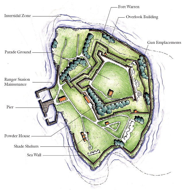
English: map of Georges Island, one of the Boston Harbor Islands in Boston, Massachusetts |
| Date | Unknown date |
| Source | NPS map from fact page |
| Author | National Park Service |
Licensing[edit]
| This image or media file contains material based on a work of a National Park Service employee, created as part of that person's official duties. As a work of the U.S. federal government, such work is in the public domain in the United States. See the NPS website and NPS copyright policy for more information. |
Original upload log[edit]
The original description page was here. All following user names refer to en.wikipedia.
- 2005-11-19 16:25 Daderot 644×659× (621071 bytes) Georges Island, one of the Boston Harbor Islands in Boston, Massachusetts, USA. This image was produced by the United States National Park Service, and as such is in the public domain and not subject to copyright restrictions.
File history
Click on a date/time to view the file as it appeared at that time.
| Date/Time | Thumbnail | Dimensions | User | Comment | |
|---|---|---|---|---|---|
| current | 21:22, 30 May 2013 | | 644 × 659 (607 KB) | LimboDancer (talk | contribs) | == {{int:filedesc}} == {{Information |Description={{en|Georges Island, one of the Boston Harbor Islands in Boston, Massachusetts, USA. This image was produced by the United States National Park Service, and as such is in the public domain and not subje... |
You cannot overwrite this file.
File usage on Commons
The following page uses this file:
File usage on other wikis
The following other wikis use this file:
- Usage on ceb.wikipedia.org
- Usage on de.wikipedia.org
- Usage on en.wikipedia.org
- Usage on en.wikivoyage.org
- Usage on eo.wikipedia.org
- Usage on www.wikidata.org