File:Geodetische Basis van Lommel Schema.jpg
Jump to navigation
Jump to search

Size of this preview: 553 × 599 pixels. Other resolutions: 221 × 240 pixels | 443 × 480 pixels | 774 × 839 pixels.
Original file (774 × 839 pixels, file size: 54 KB, MIME type: image/jpeg)
Captions
Captions
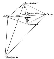
Geodesic basis of Lommel, measured in 1852, diagram from 1867
Summary[edit]
| Description |
Nederlands: Geodetische Basis van Lommel gemeten in 1852 op een schema uit 1867.
English: Geodesic base of Lommel, measured in 1852, 1867 diagram showing triangulation from the geodetic base A-B |
| Date | |
| Source |
Triangulation du Royaume de Belgique, Institut cartographique militaire; 1867 op https://books.google.be/books?id=cCpFAAAAcAAJ&printsec=frontcover&dq=triangulation+de+la+belgique&hl=nl&sa=X&redir_esc=y#v=onepage&q=triangulation%20de%20la%20belgique&f=false |
| Author | Institut cartographique militaire |
Licensing[edit]
This work is in the public domain in the United States because it was published (or registered with the U.S. Copyright Office) before January 1, 1929.
Public domain works must be out of copyright in both the United States and in the source country of the work in order to be hosted on the Commons. If the work is not a U.S. work, the file must have an additional copyright tag indicating the copyright status in the source country.
Note: This tag should not be used for sound recordings. |
| Description =
English: triangulation map
Deutsch: Die rheinisch-hessische Kette und das niederrheinsche Dreiecksnetz
| Date = 1904
File history
Click on a date/time to view the file as it appeared at that time.
| Date/Time | Thumbnail | Dimensions | User | Comment | |
|---|---|---|---|---|---|
| current | 12:30, 8 June 2017 | | 774 × 839 (54 KB) | Eebie (talk | contribs) | User created page with UploadWizard |
You cannot overwrite this file.
File usage on Commons
There are no pages that use this file.
File usage on other wikis
The following other wikis use this file:
- Usage on nl.wikipedia.org