File:Gaza Strip map sr.svg
Jump to navigation
Jump to search

Size of this PNG preview of this SVG file: 489 × 599 pixels. Other resolutions: 196 × 240 pixels | 392 × 480 pixels | 627 × 768 pixels | 836 × 1,024 pixels | 1,672 × 2,048 pixels | 725 × 888 pixels.
Original file (SVG file, nominally 725 × 888 pixels, file size: 145 KB)
Captions
Captions
Add a one-line explanation of what this file represents
Summary[edit]
| Description |
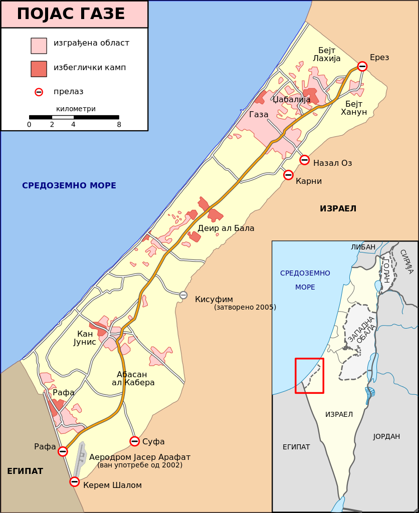
[] Bahasa Indonesia: Peta Jalur Gaza menunjukkan kota-kota utama dan negara-negara tetangga. Deutsch: Gazastreifen, urspr. English: A map of the Gaza Strip showing key towns and neighbouring countries. Español: Mapa de la Franja de Gaza Français : Carte de la bande de Gaza Norsk bokmål: Kart over Gazastripen Türkçe: Gazze Şeridi haritası, önemli kentler ve komşu ülkeler gösteriliyor. Ελληνικά: Χάρτης της Λωρίδας της Γάζας με τις κύριες πόλεις και τις γειτονικές χώρες Кыргызча: Газа тилкесинин картасы 中文(繁體): 加沙地帶(或稱加薩走廊)地圖 العربية : خارطة قطاع غزة |
| Date | (UTC) |
| Source |
This file was derived from: Gaza Strip map2.svg:  |
| Author |
|
| Other versions |
[] Ver1:
Ver2:
|


| This is a retouched picture, which means that it has been digitally altered from its original version. Modifications: translated to serbian. The original can be viewed here: Gaza Strip map2.svg:
|
Licensing[edit]
I, the copyright holder of this work, hereby publish it under the following license:
This file is licensed under the Creative Commons Attribution-Share Alike 3.0 Unported license.
- You are free:
- to share – to copy, distribute and transmit the work
- to remix – to adapt the work
- Under the following conditions:
- attribution – You must give appropriate credit, provide a link to the license, and indicate if changes were made. You may do so in any reasonable manner, but not in any way that suggests the licensor endorses you or your use.
- share alike – If you remix, transform, or build upon the material, you must distribute your contributions under the same or compatible license as the original.
Original upload log[edit]
This image is a derivative work of the following images:
- File:Gaza_Strip_map2.svg licensed with Cc-by-sa-3.0
- 2009-01-08T14:21:27Z Gringer 725x888 (332403 Bytes) Converted text to paths... it looks too bad in smaller versions
- 2009-01-08T14:01:41Z Gringer 725x888 (142822 Bytes) {{Information |Description={{en|1=Map of [[:en:Gaza Strip|Gaza Strip]], Stand December 2008 (SVG version of [[:File:Gaza_Strip_map.png]])}} |Source=SVG version of [[:File:Gaza_Strip_map.png]], used: * For Country Borders: [ht
Uploaded with derivativeFX
File history
Click on a date/time to view the file as it appeared at that time.
| Date/Time | Thumbnail | Dimensions | User | Comment | |
|---|---|---|---|---|---|
| current | 02:17, 30 November 2012 | | 725 × 888 (145 KB) | BokicaK (talk | contribs) | spelling |
| 03:30, 25 November 2012 |  | 725 × 888 (145 KB) | BokicaK (talk | contribs) | == {{int:filedesc}} == {{Information |Description={{en|1=Map of Gaza Strip, Stand December 2008 (SVG version of File:Gaza Strip map.png by Lencer)}} {{fr|Carte de la bande de Gaza (décembre 2008)}} |Source={{Der... |
You cannot overwrite this file.
File usage on Commons
The following 34 pages use this file:
- File:Gaza Strip el.svg
- File:Gaza Strip map-hu.svg
- File:Gaza Strip map-ru.svg
- File:Gaza Strip map.png
- File:Gaza Strip map.svg
- File:Gaza Strip map2-ar1.svg
- File:Gaza Strip map2.svg
- File:Gaza Strip map2 hr.svg
- File:Gaza Strip map2 id.svg
- File:Gaza Strip map2 ko.svg
- File:Gaza Strip map2 uk.svg
- File:Gaza Strip map2 zh1.svg
- File:Gaza Strip map - ITA.svg
- File:Gaza Strip map - fr.svg
- File:Gaza Strip map 2 polish version polska wersja pl.svg
- File:Gaza Strip map blank.svg
- File:Gaza Strip map el.svg
- File:Gaza Strip map fa.svg
- File:Gaza Strip map mk.svg
- File:Gaza Strip map sr.svg
- File:Gaza Strip ro.svg
- File:Gazastreifen Karte.png
- File:Gazastrook Nederlandstalige kaart.svg
- File:Gz-map-fr.png
- File:Gz-map-no.png
- File:Gz-map-tr.png
- File:Gz-map.png
- File:Gz-mapa.png
- File:Mapa De La Franja De Gaza-ca.svg
- File:Mapa da Faixa de Gaza.svg
- File:Mapa de la Franja de Gaza.svg
- File:Stráice Gaza learscail.svg
- File:مخيم رفح svg.jpg
- Template:Other versions/Gaza Strip map
File usage on other wikis
The following other wikis use this file:
- Usage on sh.wikipedia.org
- Usage on sr.wikipedia.org