File:Gaza Strip location map.svg
Jump to navigation
Jump to search

Size of this PNG preview of this SVG file: 195 × 204 pixels. Other resolutions: 229 × 240 pixels | 459 × 480 pixels | 734 × 768 pixels | 979 × 1,024 pixels | 1,958 × 2,048 pixels.
Original file (SVG file, nominally 195 × 204 pixels, file size: 95 KB)
Captions
Captions
Add a one-line explanation of what this file represents
Summary[edit]
| Description |
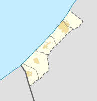
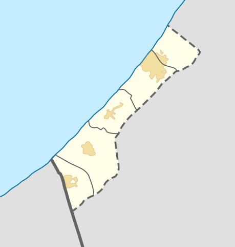
English: Location map of the Gaza Strip.
Français : Carte de géolocalisation dans la bande de Gaza.
|
||||||||||||
| Date | |||||||||||||
| Source | Own work based on: West Bank and Gaza Strip location map.svg and Gaza Strip map blank.svg | ||||||||||||
| Author | GrandEscogriffe + source files authors | ||||||||||||
Licensing[edit]
This file is licensed under the Creative Commons Attribution-Share Alike 4.0 International license.
- You are free:
- to share – to copy, distribute and transmit the work
- to remix – to adapt the work
- Under the following conditions:
- attribution – You must give appropriate credit, provide a link to the license, and indicate if changes were made. You may do so in any reasonable manner, but not in any way that suggests the licensor endorses you or your use.
- share alike – If you remix, transform, or build upon the material, you must distribute your contributions under the same or compatible license as the original.
File history
Click on a date/time to view the file as it appeared at that time.
| Date/Time | Thumbnail | Dimensions | User | Comment | |
|---|---|---|---|---|---|
| current | 21:04, 24 October 2023 | | 195 × 204 (95 KB) | GrandEscogriffe (talk | contribs) | urban areas, thinner borders |
| 20:59, 24 October 2023 |  | 195 × 204 (82 KB) | GrandEscogriffe (talk | contribs) | Uploaded a work by {{u|NordNordWest}}, {{u|GrandEscogriffe}} from {{derived from|West Bank and Gaza Strip location map.svg}} with UploadWizard |
You cannot overwrite this file.
File usage on Commons
There are no pages that use this file.
File usage on other wikis
The following other wikis use this file:
- Usage on fr.wikipedia.org
- Gaza
- Rafah
- Kfar Darom
- Khan Younès
- Jabaliya (bande de Gaza)
- Beit Hanoun
- Wikipédia:Atelier graphique/Cartes/Archives/Demandes mises en sommeil
- Jabaliya (camp)
- Al-Shati
- Deir el-Balah (camp)
- Bureij
- Maghazi
- Aéroport international Yasser Arafat
- Deir el-Balah
- Bataille de Shuja'iyya
- Shuja'iyya
- Aéroport de Gush Katif
- Modèle:Géolocalisation/Bande de Gaza
- Modèle:Géolocalisation/Bande de Gaza/Documentation
- Attaque du Hamas contre Israël de 2023
- Explosion à l'hôpital Al-Ahli Arabi
- Hôpital Al-Ahli Arabi
- Bombardement de l'église Saint-Porphyre de Gaza
- Bombardements du camp de réfugiés de Jabaliya
- Bombardement du convoi médical d'Al-Shifa
- Utilisateur:Fbrh47/Meurtre de Hind Rajab
- Massacre de la farine
- Frappe aérienne sur Rafah