File:Garet el Djenoun Teffedest Algeria.jpg
Jump to navigation
Jump to search

Size of this preview: 739 × 600 pixels. Other resolutions: 296 × 240 pixels | 592 × 480 pixels | 947 × 768 pixels | 1,262 × 1,024 pixels | 2,434 × 1,975 pixels.
Original file (2,434 × 1,975 pixels, file size: 1.98 MB, MIME type: image/jpeg)
Captions
Captions
Add a one-line explanation of what this file represents
Summary[edit]
| Description |
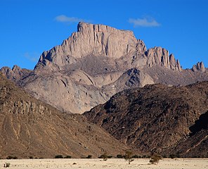
Deutsch: Udan (Name im Tamahaq) oder Garet el Djenoun (›Berg der Geister‹ im Arabischen), der nördlichste und höchste Gipfel des Teffedest-Gebirges in Südalgerien.
English: Oudane (name in Tamahaq) or Garet el Djenoun (‘mountain of genies/spirits’ in Arab), northernmost and highest peak of the Teffedest mountain range in South Algeria.
Español: Oudane (nombre en idioma targuí) o Garet el Djenoun (‹monte do los fantasmas/espíritus› en árabe), la cumbre más alta y más septentrional de la montaña Tefedest en el sur de Argelia.
Français : Oudane (nom en Tamahaq) ou Garet el Djenoun (‹ montagne des génies/esprits › en Arabe), le pic plus nord et haut de la chaîne des montagnes Teffedest en Algérie sud. |
| Date | |
| Source | Own work |
| Author | Linus Wolf |
| Camera location | | View this and other nearby images on: OpenStreetMap |
|---|
| This is a retouched picture, which means that it has been digitally altered from its original version. Modifications: cropped; curves; saturation; contrast. Modifications made by Linus Wolf.
|
Licensing[edit]
I, the copyright holder of this work, hereby publish it under the following licenses:

|
Permission is granted to copy, distribute and/or modify this document under the terms of the GNU Free Documentation License, Version 1.2 or any later version published by the Free Software Foundation; with no Invariant Sections, no Front-Cover Texts, and no Back-Cover Texts. A copy of the license is included in the section entitled GNU Free Documentation License. |
This file is licensed under the Creative Commons Attribution-Share Alike 3.0 Unported, 2.5 Generic, 2.0 Generic and 1.0 Generic license.
- You are free:
- to share – to copy, distribute and transmit the work
- to remix – to adapt the work
- Under the following conditions:
- attribution – You must give appropriate credit, provide a link to the license, and indicate if changes were made. You may do so in any reasonable manner, but not in any way that suggests the licensor endorses you or your use.
- share alike – If you remix, transform, or build upon the material, you must distribute your contributions under the same or compatible license as the original.
You may select the license of your choice.
File history
Click on a date/time to view the file as it appeared at that time.
| Date/Time | Thumbnail | Dimensions | User | Comment | |
|---|---|---|---|---|---|
| current | 01:00, 4 May 2010 | | 2,434 × 1,975 (1.98 MB) | Linus Wolf (talk | contribs) | {{Retouched|cropped; curves; contrast|editor=Linus Wolf}} |
| 00:56, 4 May 2010 |  | 3,008 × 2,000 (3.26 MB) | Linus Wolf (talk | contribs) | {{Information |Description={{en|1=Mount Oudan (name im Tamahaq) or Garet el Djenoun (‘mountain of ghosts/spirits’ in Arab), northernmost and highest peak of the Teffedest mountain range in South Algeria.}} {{de|1=Der Berg Udan (Name im Tamahaq) oder G |
You cannot overwrite this file.
File usage on Commons
The following 2 pages use this file:
File usage on other wikis
The following other wikis use this file:
- Usage on ar.wikipedia.org
- Usage on arz.wikipedia.org
- Usage on ceb.wikipedia.org
- Usage on de.wikipedia.org
- Usage on el.wikipedia.org
- Usage on en.wikipedia.org
- Usage on it.wikipedia.org
- Usage on pl.wiktionary.org
- Usage on sw.wikipedia.org
- Usage on www.wikidata.org
- Usage on zh.wikipedia.org