File:GFS metmap Xynthia.png
Jump to navigation
Jump to search
Size of this preview: 544 × 599 pixels. Other resolutions: 218 × 240 pixels | 632 × 696 pixels.
Original file (632 × 696 pixels, file size: 34 KB, MIME type: image/png)
Captions
Captions
Add a one-line explanation of what this file represents
Summary[edit]
| Description |
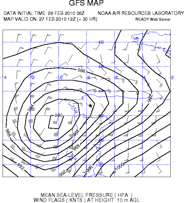
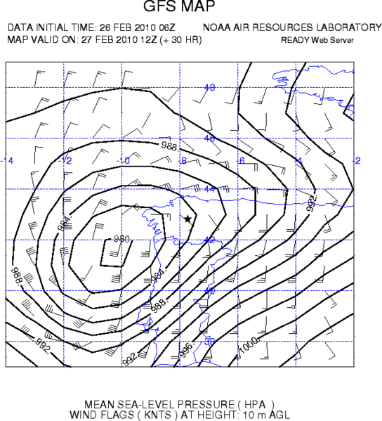
English: GFS metmap of Zynthia extratropical ciclone at 27 feb 2010, 1200 UTC (+30h forecast) offshore Galicia (Spain). The map shows sea level pressure and wind flags.
Español: Modelo meteorólogico GFS del ciclón extratropical Zynthia el 25 de febrero a las 12:00 UTC (previsión a 30 horas) en frente de las costas de Galicia (España). El mapa muestra la presión a nivel del mar y la fuerza del viento |
| Date | |
| Source | http://ready.arl.noaa.gov/ready2-bin/metmap1.pl Air Resources Laboratory |
| Author | NOAA (PNG version with better resolution) |
Licensing[edit]
This image is in the public domain because it contains materials that originally came from the U.S. National Oceanic and Atmospheric Administration, taken or made as part of an employee's official duties.
|
File history
Click on a date/time to view the file as it appeared at that time.
| Date/Time | Thumbnail | Dimensions | User | Comment | |
|---|---|---|---|---|---|
| current | 02:08, 2 March 2010 | | 632 × 696 (34 KB) | Pierre cb (talk | contribs) | {{Information |Description={{en|1=GFS metmap of Zynthia extratropical ciclone at 27 feb 2010, 1200 UTC (+30h forecast) offshore Galicia (Spain). The map shows sea level pressure and wind flags.}} {{fr|1=Modelo meteorólogico GFS del ciclón extratropical |
You cannot overwrite this file.
File usage on Commons
There are no pages that use this file.
File usage on other wikis
The following other wikis use this file:
- Usage on de.wikipedia.org
- Usage on el.wikipedia.org
- Usage on fr.wikipedia.org