File:Górki Grochowskie wieś Fort XI Warszawa.gif
From Wikimedia Commons, the free media repository
Jump to navigation
Jump to search
Górki_Grochowskie_wieś_Fort_XI_Warszawa.gif (546 × 600 pixels, file size: 53 KB, MIME type: image/gif)
File information
Structured data
Captions
Captions
Add a one-line explanation of what this file represents
| Open this image as an overlay in Google Earth (Google Maps, Bing) | (Help|Source) |
Summary
[edit]| DescriptionGórki Grochowskie wieś Fort XI Warszawa.gif |
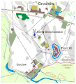
Polski: Wieś Górki Grochowskie i Fort XI zaborowej Twierdzy Warszawa - mapa. |
| Date | |
| Source |
Own work using: (praca własna z wykorzystaniem:). Mapa wykonana głównie na podstawie fragmentu niemieckiej mapy wojskowej z 1914 roku (będącej kopią mapy rosyjskiej):
|
| Author | Darekk2 |
Licensing
[edit]This file is licensed under the Creative Commons Attribution-Share Alike 3.0 Unported license.
Attribution: The author of the work
and Kart. Abt. des stellv. Generalstabes der Armee
and Kart. Abt. des stellv. Generalstabes der Armee
- You are free:
- to share – to copy, distribute and transmit the work
- to remix – to adapt the work
- Under the following conditions:
- attribution – You must give appropriate credit, provide a link to the license, and indicate if changes were made. You may do so in any reasonable manner, but not in any way that suggests the licensor endorses you or your use.
- share alike – If you remix, transform, or build upon the material, you must distribute your contributions under the same or compatible license as the original.
File history
Click on a date/time to view the file as it appeared at that time.
| Date/Time | Thumbnail | Dimensions | User | Comment | |
|---|---|---|---|---|---|
| current | 15:41, 26 November 2013 |  | 546 × 600 (53 KB) | Darekk2 (talk | contribs) | dodanie jeszcze jednej, małej poziomicy |
| 17:50, 25 November 2013 |  | 546 × 600 (53 KB) | Darekk2 (talk | contribs) | dopracowanie fortu | |
| 16:12, 25 November 2013 |  | 546 × 600 (53 KB) | Darekk2 (talk | contribs) | drobne wyrównanie paru linii | |
| 14:26, 25 November 2013 |  | 546 × 600 (53 KB) | Darekk2 (talk | contribs) | nieco poprawiony fort | |
| 14:07, 25 November 2013 |  | 546 × 600 (53 KB) | Darekk2 (talk | contribs) | User created page with UploadWizard |
You cannot overwrite this file.
File usage on Commons
There are no pages that use this file.
File usage on other wikis
The following other wikis use this file:
- Usage on pl.wikipedia.org
