File:Frankish Empire 481 to 814-nl 2.svg
(Redirected from File:Frankish Empire 481 to 814-de nl.svg)

Size of this PNG preview of this SVG file: 800 × 566 pixels. Other resolutions: 320 × 226 pixels | 640 × 453 pixels | 1,024 × 724 pixels | 1,280 × 905 pixels | 2,560 × 1,810 pixels | 1,735 × 1,227 pixels.
Original file (SVG file, nominally 1,735 × 1,227 pixels, file size: 332 KB)
Captions
Captions
Add a one-line explanation of what this file represents
Summary[edit]
| Description |
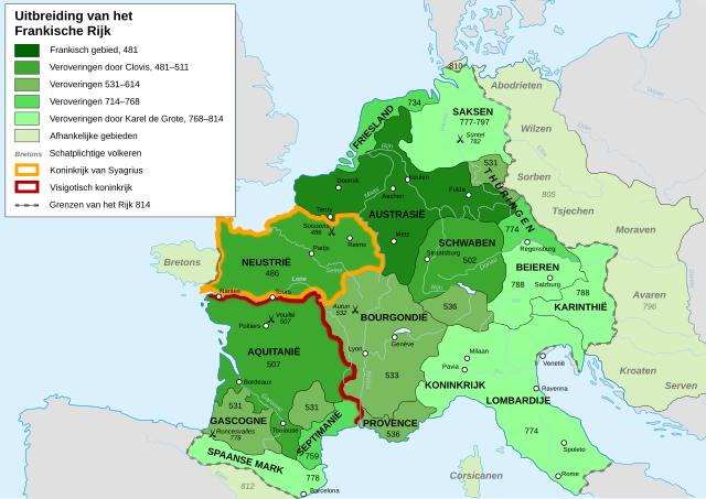
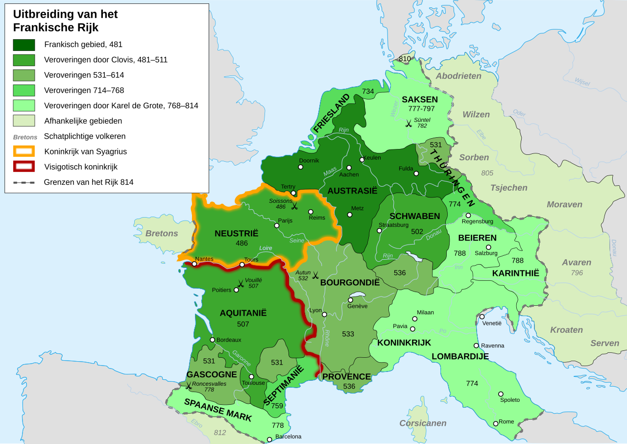
[] Afrikaans: Die veranderende strekking van die Frankiese Ryk van 481 tot 814. Alemannisch: S Frankeriich vo 481 bis 814. Bahasa Indonesia: Peta kebangkitan Kekaisaran Franka, dari tahun 481 hingga 814. Català: Mapa de l'expansió de l'Imperi Franc, de 481 a 814. Deutsch: Karte der Ausdehnung des Fränkischen Reichs 481 bis 814. English: Map of the rise of Frankish Empire, from 481 to 814. Español: Mapa de la expansión del Imperio Franco, entre 481 y 814. Euskara: Frankoen Inperioaren hedapenaren mapa, 481-814 urteen bitartean. Français : Carte de l'expansion de l'empire Franc, entre 481 et 814. Italiano: Carta dell'espansione dell'impero dei Franchi tra il 481 e il 814. Magyar: Frank Birodalom 481-814 Nederlands: Kaart van de opkomst van het Frankische Rijk, van 481 tot 814. Polski: Mapa rozwoju Imperium Franków w latach 481-814 Português: Mapa da expansão do Império Franco, entre 481 e 814. Română: Harta ascensiunii Imperiului franc, 481-814. Svenska: Karantanien i det frankiska riket (år 788 - 843). Ελληνικά: Η Φραγκική Αυτοκρατορία 481-814 Македонски: Карта на подемот на Франкското царство, од 481 до 814 г. Русский: Карта расширения империи франков, между 481 и 814. Українська: Карта розширення імперії Франків в період 481-814 рр. 日本語: カロリング朝の版図。 中文: 墨洛温王朝到加洛林王朝(481—814)的法兰克王国。 العربية : إمبراطوريَّة الفرنجة ما بين عاميّ 481 و814م |
| Date | |
| Source | File:Frankish Empire 481 to 814-de.svg, itself from from the Historical Atlas by William R. Shepherd (Shepherd, William. Historical Atlas. New York: Henry Holt and Company, 1911.) |
| Author | Druifkes |
| Other versions |
[]
|
Licensing[edit]
I, the copyright holder of this work, hereby publish it under the following licenses:
This file is licensed under the Creative Commons Attribution-Share Alike 3.0 Unported license.
- You are free:
- to share – to copy, distribute and transmit the work
- to remix – to adapt the work
- Under the following conditions:
- attribution – You must give appropriate credit, provide a link to the license, and indicate if changes were made. You may do so in any reasonable manner, but not in any way that suggests the licensor endorses you or your use.
- share alike – If you remix, transform, or build upon the material, you must distribute your contributions under the same or compatible license as the original.

|
Permission is granted to copy, distribute and/or modify this document under the terms of the GNU Free Documentation License, Version 1.2 or any later version published by the Free Software Foundation; with no Invariant Sections, no Front-Cover Texts, and no Back-Cover Texts. A copy of the license is included in the section entitled GNU Free Documentation License. |
You may select the license of your choice.
File history
Click on a date/time to view the file as it appeared at that time.
| Date/Time | Thumbnail | Dimensions | User | Comment | |
|---|---|---|---|---|---|
| current | 10:48, 25 August 2013 | | 1,735 × 1,227 (332 KB) | Qwertyus (talk | contribs) | "met een verplichte afdracht" → "schatplichtig" (Dutch word for tributary) |
| 10:45, 25 August 2013 |  | 1,735 × 1,227 (332 KB) | Qwertyus (talk | contribs) | Corrected grammar and names (of Slavic tribes in particular). | |
| 13:45, 4 March 2009 |  | 1,735 × 1,227 (332 KB) | Druifkes (talk | contribs) | {{Information |Description={{nl|1=Map van het Frankische Rijk Map of the Frankish Empire}} |Source=File:Frankish Empire 481 to 814-blank.svg, itself from from the Historical Atlas by William R. Shepherd (Shepherd, William. Historical Atlas. New York: Henr |
You cannot overwrite this file.
File usage on Commons
The following page uses this file:
- File:Frankish Empire 481 to 814-de nl.svg (file redirect)
File usage on other wikis
The following other wikis use this file:
- Usage on de.wikipedia.org
- Usage on nds-nl.wikipedia.org
- Usage on nl.wikipedia.org