File:France May 1940.svg
Jump to navigation
Jump to search

Size of this PNG preview of this SVG file: 624 × 600 pixels. Other resolutions: 250 × 240 pixels | 499 × 480 pixels | 799 × 768 pixels | 1,066 × 1,024 pixels | 2,131 × 2,048 pixels | 2,000 × 1,922 pixels.
Original file (SVG file, nominally 2,000 × 1,922 pixels, file size: 764 KB)
Captions
Captions
Add a one-line explanation of what this file represents
| Description |
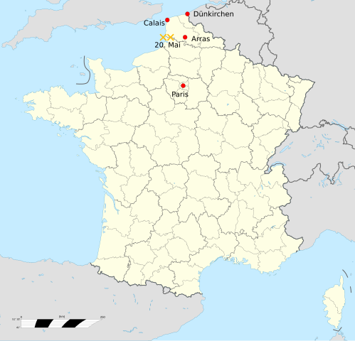
English: Blank administrative map of France for geo-location purpose, with regions and departements distinguished. Approximate scale : 1:3,000,000 Français : Carte administrative vierge de la France destinée à la géolocalisation, avec régions et départements distingués. Equirectangular projection, WGS84 datumÉchelle approximative : 1:3 000 000 *Central meridian: 002° 06' E *True scale parallel: 46° 15' N Geographic limits of the map : *West : 005° 48' W *East : 10° E *North : 51° 30' N *South : 41° N English: Alternativ Logo of the 2nd German Tank Division, 1935-1945. II World War. Deutsch: Weiteres Logo der 2. Deutschen Panzerdivision der Wehrmacht |
| Date | (UTC) |
| Source | |
| Author |
|
| This is a retouched picture, which means that it has been digitally altered from its original version. Modifications: Calais, Aras, Dünkirchen und die Position der 2. Panzerdivision am 20. Mai hinzugefügt. The original can be viewed here: 2nd Panzer Division logo2.svg:
|
This file is licensed under the Creative Commons Attribution-Share Alike 3.0 Unported license.
- You are free:
- to share – to copy, distribute and transmit the work
- to remix – to adapt the work
- Under the following conditions:
- attribution – You must give appropriate credit, provide a link to the license, and indicate if changes were made. You may do so in any reasonable manner, but not in any way that suggests the licensor endorses you or your use.
- share alike – If you remix, transform, or build upon the material, you must distribute your contributions under the same or compatible license as the original.
Original upload log[edit]
This image is a derivative work of the following images:
- File:France_location_map-Regions_and_departements.svg licensed with Cc-by-sa-3.0,2.5,2.0,1.0, GFDL
- 2009-02-02T16:12:50Z Yug 2000x1922 (772026 Bytes) Restore light style version ; a specific file name will be use for polygon departement maps.
- 2009-02-01T19:34:09Z Yug 2000x1922 (1849428 Bytes) restore East and southern border deleted by mistake + code improving.
- 2009-02-01T14:41:40Z Yug 2000x1922 (1852045 Bytes) Statistic friendly added, as an upper layer.
- 2008-11-07T13:23:10Z Sting 2000x1922 (772026 Bytes) + boundary for Channel Islands
- 2008-08-23T16:29:48Z Sting 2000x1922 (769918 Bytes) Larger strokes for boundaries
- 2008-07-25T17:35:54Z Sting 2000x1922 (770878 Bytes) Display bug
- 2008-07-25T17:28:38Z Sting 2000x1922 (772649 Bytes) Variable scale
- 2008-07-25T14:29:27Z Sting 2000x1922 (773101 Bytes) - border
- 2008-07-25T14:23:11Z Sting 2000x1922 (773214 Bytes) Other countries' color
- 2008-07-04T20:32:47Z Sting 2000x1922 (772973 Bytes) == Summary == {{Location|46|15|00|N|02|06|00|E|scale:10000000}} {{Information |Description={{en|Blank administrative map of [[:en:France|France]] for geo-location purpose, with regions and departements distinguished.Approxim
- File:2nd_Panzer_Division_logo2.svg licensed with PD-self
- 2008-08-16T10:28:27Z Marco Kaiser 293x147 (5397 Bytes) {{Information |Description={{en|1=Alternativ Logo of the 2nd German Tank Division, 1935-1945. II World War.}} {{de|1=Weiteres Logo der 2. Deutschen Panzerdivision der Wehrmacht}} |Source=Own work by uploader |Author=[[User:Ma
Uploaded with derivativeFX
File history
Click on a date/time to view the file as it appeared at that time.
| Date/Time | Thumbnail | Dimensions | User | Comment | |
|---|---|---|---|---|---|
| current | 04:22, 17 April 2010 | | 2,000 × 1,922 (764 KB) | MartinThoma (talk | contribs) | Aras -> Arras |
| 04:19, 17 April 2010 |  | 2,000 × 1,922 (764 KB) | MartinThoma (talk | contribs) | {{Information |Description={{en|Blank administrative map of France for geo-location purpose, with regions and departements distinguished.<br/>Approximate scale : 1:3,000,000}} {{fr|Carte administrative vierge de la France des |
You cannot overwrite this file.
File usage on Commons
There are no pages that use this file.