File:France 1154-es.svg
Jump to navigation
Jump to search

Size of this PNG preview of this SVG file: 503 × 600 pixels. Other resolutions: 201 × 240 pixels | 403 × 480 pixels | 644 × 768 pixels | 859 × 1,024 pixels | 1,718 × 2,048 pixels | 1,405 × 1,675 pixels.
Original file (SVG file, nominally 1,405 × 1,675 pixels, file size: 1.14 MB)
Captions
Captions
Add a one-line explanation of what this file represents
Summary[edit]
| Description |
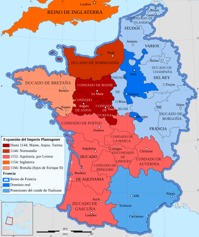
English: French map of the growth of the Plantagenet Empire, from 1144 to 1166.
Español: Mapa de la expansión del Imperio Plantagenet entre el 1144 y el 1166.
Français : Carte en français de l'expansion de l'empire Plantagenêt, de 1144 à 1166. |
| Date | (UTC) |
| Source |
This file was derived from: France 1154-fr.svg:  |
| Author |
|
| Other versions |
[]
|


| This is a retouched picture, which means that it has been digitally altered from its original version. Modifications: translated into Spanish. The original can be viewed here: France 1154-fr.svg:
|
Licensing[edit]
This file is licensed under the Creative Commons Attribution-Share Alike 3.0 Unported license.
- You are free:
- to share – to copy, distribute and transmit the work
- to remix – to adapt the work
- Under the following conditions:
- attribution – You must give appropriate credit, provide a link to the license, and indicate if changes were made. You may do so in any reasonable manner, but not in any way that suggests the licensor endorses you or your use.
- share alike – If you remix, transform, or build upon the material, you must distribute your contributions under the same or compatible license as the original.
Original upload log[edit]
This image is a derivative work of the following images:
- File:France_1154-fr.svg licensed with Cc-by-sa-3.0,2.5,2.0,1.0, GFDL
- 2012-01-27T08:53:40Z Sémhur 1405x1675 (555138 Bytes) Few mistakes in legend
- 2009-07-27T11:44:00Z Sémhur 1405x1675 (694467 Bytes) == {{int:filedesc}} == {{Information |Description= {{en|French map of the growth of the Plantagenet Empire, from 1144 to 1166.}} {{fr|Carte en français de l'expansion de l'empire Plantagenêt, de 1144 à 1166.}} |Source={{ow
Uploaded with derivativeFX
File history
Click on a date/time to view the file as it appeared at that time.
| Date/Time | Thumbnail | Dimensions | User | Comment | |
|---|---|---|---|---|---|
| current | 11:22, 1 July 2021 | | 1,405 × 1,675 (1.14 MB) | Rowanwindwhistler (talk | contribs) | Fake text added to improve rendering and readability in articles. |
| 16:17, 5 July 2016 |  | 1,405 × 1,675 (544 KB) | Rowanwindwhistler (talk | contribs) | New try | |
| 16:11, 5 July 2016 |  | 1,405 × 1,675 (539 KB) | Rowanwindwhistler (talk | contribs) | Font workaround again... | |
| 16:07, 5 July 2016 |  | 1,405 × 1,675 (539 KB) | Rowanwindwhistler (talk | contribs) | New font | |
| 10:15, 5 July 2016 |  | 1,405 × 1,675 (539 KB) | Rowanwindwhistler (talk | contribs) | Font workaround | |
| 10:13, 5 July 2016 |  | 1,405 × 1,675 (539 KB) | Rowanwindwhistler (talk | contribs) | Errors in text corrected, larger fonts | |
| 19:00, 11 April 2013 |  | 1,405 × 1,675 (538 KB) | Rowanwindwhistler (talk | contribs) | == {{int:filedesc}} == {{Information |Description={{en|French map of the growth of the Plantagenet Empire, from 1144 to 1166.}} {{es|1=Mapa de la expansión del Imperio Plantagenet entre el 1144 y el 1166.}} {{fr|Carte en français de l'expansion de l... |
You cannot overwrite this file.
File usage on Commons
The following 18 pages use this file:
- User:Magog the Ogre/Multilingual legend/2021 July 1-10
- File:France 1154-ar.svg
- File:France 1154-en.svg
- File:France 1154-es.svg
- File:France 1154-fr.png
- File:France 1154-fr.svg
- File:France 1154-hu.svg
- File:France 1154-it.svg
- File:France 1154-ko.svg
- File:France 1154-nl.svg
- File:France 1154-ru.svg
- File:France 1154.jpg
- File:France 1154.svg
- File:France 1154 Eng-ar.png
- File:France 1154 Eng.jpg
- File:Frankreich 1154-DE.svg
- File:Frañs 1154-br.svg
- Template:Other versions/France 1154
File usage on other wikis
The following other wikis use this file:
- Usage on es.wikipedia.org
- Usage on gl.wikipedia.org