File:Foundations of the church of Saint Tygwydd.jpg
Jump to navigation
Jump to search

Size of this preview: 800 × 600 pixels. Other resolutions: 320 × 240 pixels | 640 × 480 pixels | 1,024 × 768 pixels | 1,280 × 960 pixels | 1,600 × 1,200 pixels.
Original file (1,600 × 1,200 pixels, file size: 447 KB, MIME type: image/jpeg)
Captions
Captions
Add a one-line explanation of what this file represents
| Description |
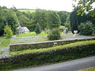
English: Foundations of the church of St. Tygwydd, Llandygwydd, Ceredigion, Wales. Clearly the church built in 1857 stood here. The font is in the position marked on this ground plan. Indeed the boot scrapers are still in position by the steps up to the porch. But the church has completely disappeared. The only clue I have so far found is its mention in this list of listed buildings demolished in 1999.
A smaller building nearby is now used as the church. |
| Date | |
| Source | see below |
| Author | Roger W Haworth |
| Permission (Reusing this file) |
Creative Commons Attribution Share-alike license 2.0 |
| Camera location | | View this and other nearby images on: OpenStreetMap |
|---|

|
This image was taken from the Geograph project collection. See this photograph's page on the Geograph website for the photographer's contact details. The copyright on this image is owned by Roger W Haworth and is licensed for reuse under the Creative Commons Attribution-ShareAlike 2.0 license.
|
This file is licensed under the Creative Commons Attribution-Share Alike 2.0 Generic license.
Attribution: Roger W Haworth
- You are free:
- to share – to copy, distribute and transmit the work
- to remix – to adapt the work
- Under the following conditions:
- attribution – You must give appropriate credit, provide a link to the license, and indicate if changes were made. You may do so in any reasonable manner, but not in any way that suggests the licensor endorses you or your use.
- share alike – If you remix, transform, or build upon the material, you must distribute your contributions under the same or compatible license as the original.
File history
Click on a date/time to view the file as it appeared at that time.
| Date/Time | Thumbnail | Dimensions | User | Comment | |
|---|---|---|---|---|---|
| current | 11:14, 20 May 2010 | | 1,600 × 1,200 (447 KB) | RHaworth (talk | contribs) | higher res |
| 20:05, 22 February 2009 |  | 640 × 480 (139 KB) | Kapohogrrl (talk | contribs) | {{Information |Description=Foundations of the church of St. Tygwydd. |Source=From [http://www.geograph.org.uk/photo/572026 geograph.org.uk] |Date=2007-09-18 |Author=[http://www.geograph.org.uk/profile/3860 Roger W Haworth] |Permission=Creative Commons At |
You cannot overwrite this file.
File usage on Commons
The following 3 pages use this file:
File usage on other wikis
The following other wikis use this file:
- Usage on ca.wikipedia.org
- Usage on cy.wikipedia.org
- Usage on en.wikipedia.org
- Usage on eu.wikipedia.org
- Usage on www.wikidata.org