File:Fort Bragg California aerial view.jpg
Jump to navigation
Jump to search
Size of this preview: 800 × 533 pixels. Other resolutions: 320 × 213 pixels | 640 × 427 pixels | 1,024 × 683 pixels | 1,500 × 1,000 pixels.
Original file (1,500 × 1,000 pixels, file size: 724 KB, MIME type: image/jpeg)
Captions
Captions
Add a one-line explanation of what this file represents
| Description |
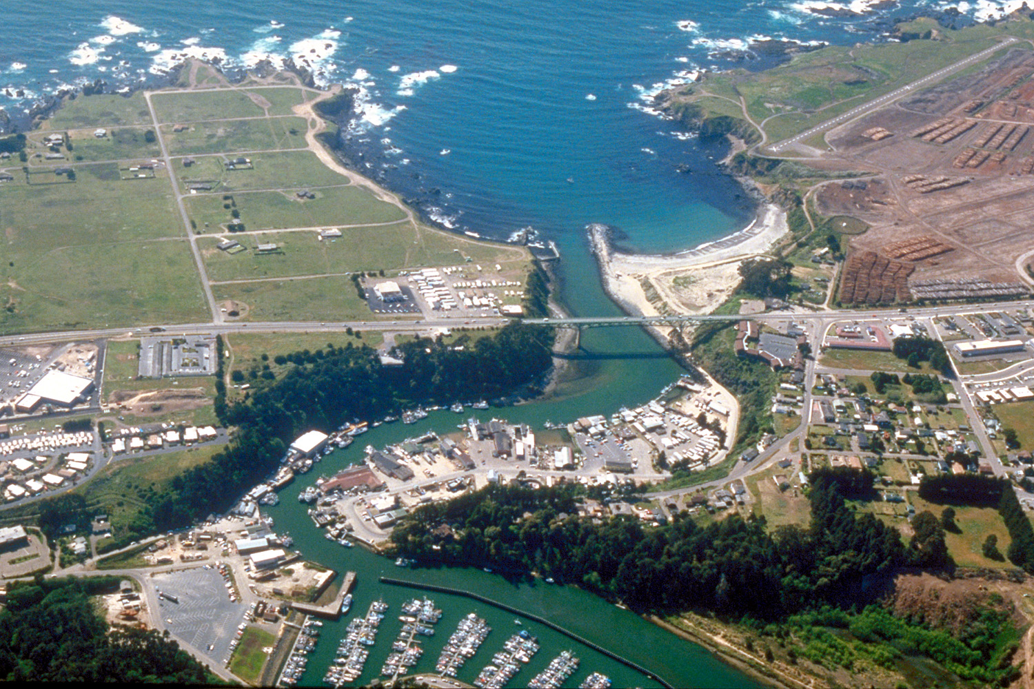
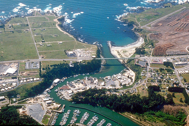
English: Aerial view of the mouth of the Noyo River on the Pacific Ocean at Fort Bragg, Mendocino County, California, USA. California State Route 1 (Main Street in Fort Bragg) crosses the river at the outlet. View is to the west.
Coordinates: 39°25′38.37″N 123°48′24.63″W / 39.427325°N 123.8068417°W |
||
| Date | not specified or unknown, 2007 or before, but judging by the view and visual of the photo, it appears to be from the mid-late 1990s. | ||
| Source |
U.S. Army Corps of Engineers Digital Visual Library Image page Image description page Digital Visual Library home page |
||
| Author | Robert Campbell | ||
| Permission (Reusing this file) |
This file is licensed under the Creative Commons Attribution-Share Alike 3.0 Unported license.
|
||
| Location | Fort Bragg, Mendocino County, California, USA |

| Camera location | | View this and other nearby images on: OpenStreetMap |
|---|
File history
Click on a date/time to view the file as it appeared at that time.
| Date/Time | Thumbnail | Dimensions | User | Comment | |
|---|---|---|---|---|---|
| current | 03:20, 3 May 2007 | | 1,500 × 1,000 (724 KB) | DanMS (talk | contribs) | {{Information | Description = {{en|Aerial view of the mouth of the Noyo River on the Pacific Ocean at Fort Bragg, Mendocino County, California, USA. California State Route 1 (Main Street in Fort Bragg) crosses the river at the outlet. View is to the we |
You cannot overwrite this file.
File usage on Commons
The following 28 pages use this file:
- Category:2021 in Fort Bragg, California
- Category:2022 in Fort Bragg, California
- Category:2024 in Fort Bragg, California
- Category:Agriculture in Mendocino County, California
- Category:Airports in Mendocino County, California
- Category:Bridges in Fort Bragg, California
- Category:Bridges in Mendocino County, California
- Category:Deaths in Mendocino County, California
- Category:Education in Mendocino County, California
- Category:Fort Bragg, California
- Category:Geography of Mendocino County, California
- Category:History of Mendocino County, California
- Category:Maps of Fort Bragg, California
- Category:Maps of Mendocino County, California
- Category:Mendocino County, California
- Category:Mendocino County, California in the 21st century
- Category:Mountains of Mendocino County, California
- Category:Native American tribes in Mendocino County, California
- Category:Nature of Mendocino County, California
- Category:Noyo Harbor
- Category:People of Mendocino County, California
- Category:Restaurants in Fort Bragg, California
- Category:Rivers of Mendocino County, California
- Category:Roads in Mendocino County, California
- Category:Transport in Mendocino County, California
- Category:Views from automobiles in Mendocino County, California
- Category:Wildfires in Mendocino County, California
- Category:Wine tasting rooms in Mendocino County, California
File usage on other wikis
The following other wikis use this file:
- Usage on ar.wikipedia.org
- Usage on arz.wikipedia.org
- Usage on az.wikipedia.org
- Usage on be.wikipedia.org
- Usage on bg.wikipedia.org
- Usage on ca.wikipedia.org
- Usage on ceb.wikipedia.org
- Usage on ce.wikipedia.org
- Usage on cs.wikipedia.org
- Usage on cy.wikipedia.org
- Usage on de.wikipedia.org
- Usage on de.wikivoyage.org
- Usage on en.wikipedia.org
- Usage on en.wikivoyage.org
- Usage on eo.wikipedia.org
- Usage on es.wikipedia.org
- Usage on eu.wikipedia.org
- Usage on fa.wikipedia.org
- Usage on fi.wikipedia.org
- Usage on fr.wikipedia.org
- Usage on ga.wikipedia.org
- Usage on gl.wikipedia.org
- Usage on he.wikivoyage.org
- Usage on ht.wikipedia.org
- Usage on hu.wikipedia.org
- Usage on hy.wikipedia.org
- Usage on it.wikipedia.org
- Usage on ko.wikipedia.org
View more global usage of this file.