File:Flume Trail to Old Fossil Creek Dam (32269388175).jpg
Original file (4,800 × 3,200 pixels, file size: 10.09 MB, MIME type: image/jpeg)
Captions
Captions
Summary[edit]
.jpg&action=edit§ion=1)
| Description |
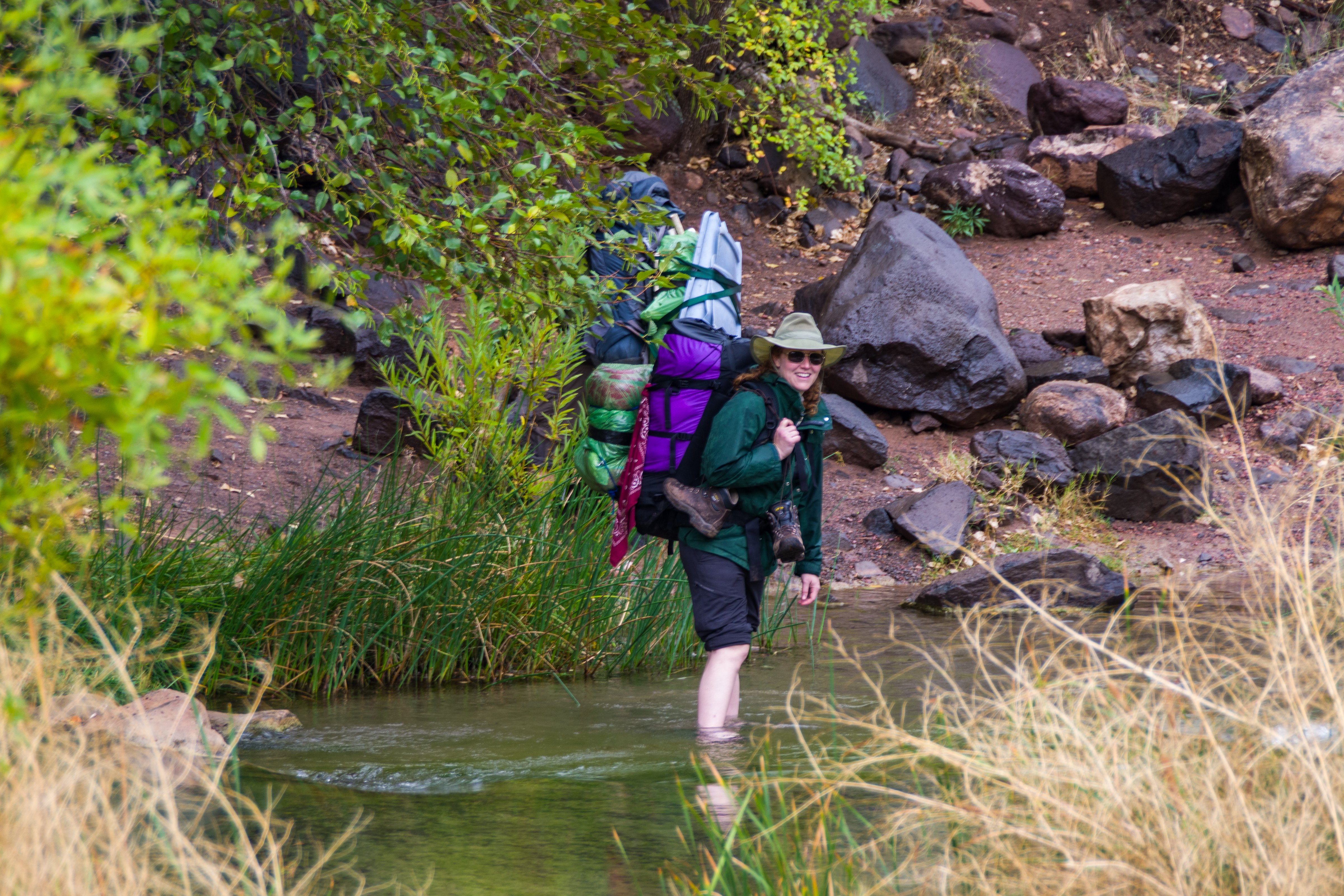
Nicole Branton crossing Fossil Creek at the Flume Trailhead at the old Irving power plant site. In early November 2016, a group of Coconino National Forest staff visited Fossil Springs to inspect the area in preparation for developing the long-term management proposal for the Fossil Creek Wild & Scenic River. The trip was attended by Red Rock District Ranger Nicole Branton, Fossil Creek Project Coordinator Marcos Roybal, Recreation Program Manager Adam Barnett, and Assistant Recreation Program Manager Francisca Adrian. The staff backpacked into the Fossil Springs area on Fossil Springs Trail for the night. They spent two days examining recreation impacts, picking up trash, breaking up illegal fire rings, surveying sites for potential recreation development, and chatting with visitors to the springs and old dam before hiking out on the Flume Trail. The nine-mile route provided team members with a broad view of the area's landscape, flora, fauna, environmental values, and recreation potential. Fossil Creek is one of only two National Wild & Scenic rivers in Arizona and is fed by springs coming from the cliffs of the Mogollon Rim. Over 30 million gallons of water are discharged each day at a constant 70°F. The high mineral content leaves travertine dams and deposits, giving rise to fossil-like features. In 2005, Arizona Public Service (APS) decommissioned the Fossil Creek diversion dam and flume. Removal of the dam and flume allowed full, unrestricted flow to be restored to Fossil Creek. In 2009, the creek was designated a National Wild & Scenic River under the Wild & Scenic Rivers Act. The Wild & Scenic River Act requires the Coconino and Tonto National Forests to develop a "Comprehensive River Management Plan" to outline the future management and development along the creek's corridor. The development of the plan has involved extensive public involvement from recreation groups, emergency response agencies, local business, and many other stakeholder groups, as well as individuals from across the state of Arizona. Photo by Deborah Lee Soltesz, November 4, 2016. Credit: Coconino National Forest, U.S. Forest Service. Learn more about <a href="https://www.fs.usda.gov/detail/coconino/landmanagement/planning/?cid=stelprdb5410835" rel="nofollow">Fossil Creek Wild and Scenic River planning effort</a> and the <a href="http://www.fs.usda.gov/main/coconino/home" rel="nofollow">Coconino National Forest</a>. |
| Date | |
| Source | Flume Trail to Old Fossil Creek Dam |
| Author | Coconino National Forest |
| Camera location | | View this and other nearby images on: OpenStreetMap |
|---|
.jpg¶ms=034.403733_N_-111.617301_E_globe:Earth_type:camera_source:Flickr_&language=en)
Licensing[edit]
.jpg&action=edit§ion=2)
| This image was originally posted to Flickr by Coconino National Forest at https://flickr.com/photos/42034606@N05/32269388175 (archive). It was reviewed on 8 September 2018 by FlickreviewR 2 and was confirmed to be licensed under the terms of the Public Domain Mark. |
This image or file is a work of a United States Department of Agriculture employee, taken or made as part of that person's official duties. As a work of the U.S. federal government, the image is in the public domain.
|
 |
File history
Click on a date/time to view the file as it appeared at that time.
| Date/Time | Thumbnail | Dimensions | User | Comment | |
|---|---|---|---|---|---|
| current | 06:23, 8 September 2018 | | 4,800 × 3,200 (10.09 MB) | Tyler ser Noche (talk | contribs) | Transferred from Flickr via #flickr2commons |
You cannot overwrite this file.
File usage on Commons
There are no pages that use this file.
.jpg&oldid=810354284)