File:Florida Northeast 1839 n034547.jpg
Jump to navigation
Jump to search

Size of this preview: 476 × 599 pixels. Other resolutions: 191 × 240 pixels | 600 × 755 pixels.
Original file (600 × 755 pixels, file size: 244 KB, MIME type: image/jpeg)
Captions
Captions
Add a one-line explanation of what this file represents
Summary[edit]
| Description |
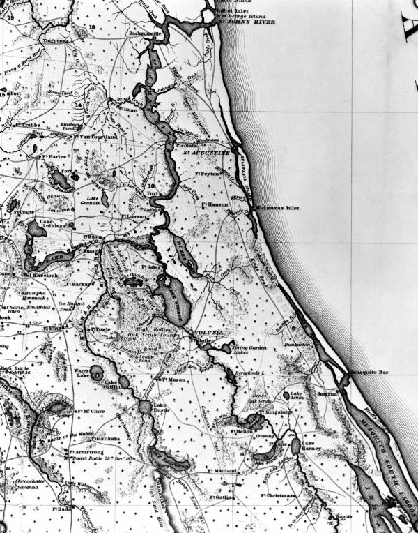
English: Section of Florida map showing east coast from St. John's River to Mosquito Lagoon, 1839. Compiled by order of Brig. Gen. Z. Taylor principally from the surveys and reconnaissances of the officers of the U.S. Army; by Capt. John Mackay and Lt. J.E. Blake, U.S. Top Eng., headquarters, Army of the South, Tampa Bay. |
| Date | |
| Source | http://fpc.dos.state.fl.us/general/n034547.jpg |
| Author | U.S. Army |
Licensing[edit]
This file is a work of a U.S. Army soldier or employee, taken or made as part of that person's official duties. As a work of the U.S. federal government, it is in the public domain in the United States.
|
 |
File history
Click on a date/time to view the file as it appeared at that time.
| Date/Time | Thumbnail | Dimensions | User | Comment | |
|---|---|---|---|---|---|
| current | 03:08, 25 May 2009 | | 600 × 755 (244 KB) | Gamweb (talk | contribs) | {{Information |Description={{en|1=Section of Florida map showing east coast from St. John's River to Mosquito Lagoon, 1839. Compiled by order of Brig. Gen. Z. Taylor principally from the surveys and reconnaissances of the officers of the U.S. Army; by Cap |
You cannot overwrite this file.
File usage on Commons
There are no pages that use this file.