File:FloridaSR520map.gif
Jump to navigation
Jump to search

Size of this preview: 800 × 373 pixels. Other resolutions: 320 × 149 pixels | 640 × 298 pixels | 1,187 × 553 pixels.
Original file (1,187 × 553 pixels, file size: 21 KB, MIME type: image/gif)
Captions
Captions
Add a one-line explanation of what this file represents
| Description |
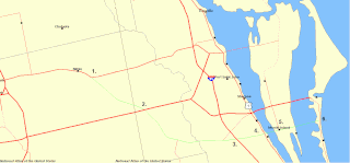
English: FL SR-520 is shown in green.
1. Western terminus at SR-50. 2. Junction with SR-528. 3. Junction with I-95. 4. Junction with US-1. 5. Junction with SR-3. 6. Eastern terminus at SR-A1A. |
|||
| Date | Unknown date | |||
| Source | National Atlas | |||
| Author | Federal Government of the United States | |||
| Permission (Reusing this file) |
|
File history
Click on a date/time to view the file as it appeared at that time.
| Date/Time | Thumbnail | Dimensions | User | Comment | |
|---|---|---|---|---|---|
| current | 16:09, 3 February 2009 | | 1,187 × 553 (21 KB) | Dromioofephesus (talk | contribs) | {{Information |Description={{en|1=FL SR-520 is shown in green. 1. Western terminus at SR-50. 2. Junction with SR-528. 3. Junction with I-95. 4. Junction with US-1. 5. Junction with SR-3. 6. Eastern terminus at SR-A1A.}} |Source=National Atlas |Author=Fed |
You cannot overwrite this file.
File usage on Commons
The following 2 pages use this file:
File usage on other wikis
The following other wikis use this file:
- Usage on www.wikidata.org