File:Flooded River Mole at Flanchford Bridge - geograph.org.uk - 1598852.jpg
Jump to navigation
Jump to search
No higher resolution available.
Flooded_River_Mole_at_Flanchford_Bridge_-_geograph.org.uk_-_1598852.jpg (640 × 426 pixels, file size: 59 KB, MIME type: image/jpeg)
Captions
Captions
Add a one-line explanation of what this file represents
Summary[edit]
| Description |
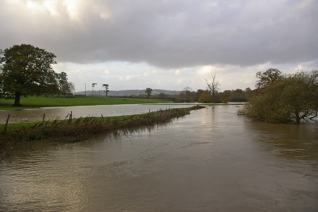
English: Flooded River Mole at Flanchford Bridge. Looking downstream along the route of the main channel.
The catchment area for the upper River Mole includes Crawley and Gatwick Airport - a lot of hard surface for heavy rain to run quickly off and into the river, which therefore regularly floods. Although on this occasion it wasn't sufficient to close the road here at Flanchford Bridge, which happens from time to time, there was nevertheless significantly more water than in drier conditions - compare 244970. In the far distance are the North Downs, with the former Betchworth Quarry visible. |
| Date | |
| Source | From geograph.org.uk |
| Author | Ian Capper |
| Attribution (required by the license) | Ian Capper / Flooded River Mole at Flanchford Bridge / |
| Camera location | | View this and other nearby images on: OpenStreetMap |
|---|
_heading:337.00&language=en)
| Object location | | View this and other nearby images on: OpenStreetMap |
|---|
_heading:337.00&language=en)
Licensing[edit]

|
This image was taken from the Geograph project collection. See this photograph's page on the Geograph website for the photographer's contact details. The copyright on this image is owned by Ian Capper and is licensed for reuse under the Creative Commons Attribution-ShareAlike 2.0 license.
|
This file is licensed under the Creative Commons Attribution-Share Alike 2.0 Generic license.
Attribution: Ian Capper
- You are free:
- to share – to copy, distribute and transmit the work
- to remix – to adapt the work
- Under the following conditions:
- attribution – You must give appropriate credit, provide a link to the license, and indicate if changes were made. You may do so in any reasonable manner, but not in any way that suggests the licensor endorses you or your use.
- share alike – If you remix, transform, or build upon the material, you must distribute your contributions under the same or compatible license as the original.
File history
Click on a date/time to view the file as it appeared at that time.
| Date/Time | Thumbnail | Dimensions | User | Comment | |
|---|---|---|---|---|---|
| current | 03:04, 4 March 2011 | | 640 × 426 (59 KB) | GeographBot (talk | contribs) | == {{int:filedesc}} == {{Information |description={{en|1=Flooded River Mole at Flanchford Bridge Looking downstream along the route of the main channel. The catchment area for the upper River Mole includes Crawley and Gatwick Airport - a lot of hard su |
You cannot overwrite this file.
File usage on Commons
There are no pages that use this file.