File:Flamborough Castle - geograph.org.uk - 1771992.jpg
Original file (3,344 × 1,881 pixels, file size: 5.15 MB, MIME type: image/jpeg)
Captions
Captions
This is a photo of listed building number 1162230. |
Summary[edit]
| Description |
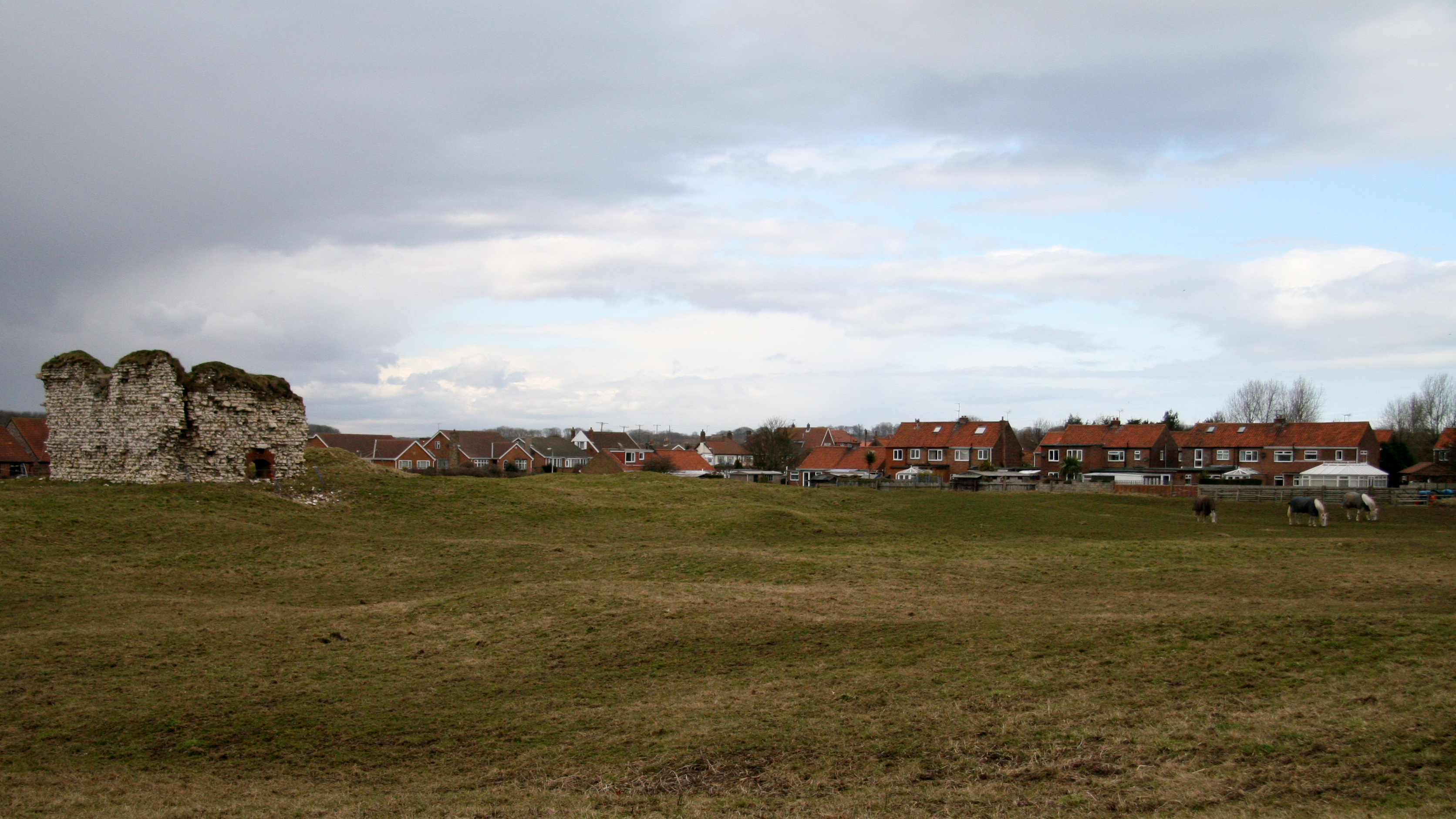
English: Flamborough Castle, Flamborough, East Riding of Yorkshire, England. The photograph shows the tower, being the only remains above ground, and associated earthworks. This 'castle' was, in fact, the fortified manor house of the Constable family who had received licence to crenelate in 1351. Although containing a tower, a hall, a great parlour, a lord's parlour, a chapel, a court house, a mill house, and a great barn it was described in the early 16th century as being taken for a manor house rather than a castle. It can be compared with the Northumbrian 'Pele' towers and, like them, was probably made defensible to guard against Scottish raiders. The above paragraph was adapted from an East Riding Council leaflet that is available online: http://www.eastriding.gov.uk/EasySiteWeb/GatewayLink.aspx?alId=2256 . Click here for another photograph of the castle: https://www.geograph.org.uk/photo/1772032 . For a photograph showing the tower, click here: https://www.geograph.org.uk/photo/1772013 . - - - For other photographs of the castle see the following by: Paul Allison: 1862, Paul Glazzard: 835908 and J Thomas: 1212589. |
| Date | |
| Source | From geograph.org.uk |
| Author | Alan Walker |
| Permission (Reusing this file) |
Creative Commons Attribution Share-alike license 2.0 |
| Attribution (required by the license) | Alan Walker / Flamborough Castle / |
| Camera location | | View this and other nearby images on: OpenStreetMap |
|---|
_heading:315.00&language=en)
| Object location | | View this and other nearby images on: OpenStreetMap |
|---|
_heading:315.00&language=en)
Licensing[edit]

|
This image was taken from the Geograph project collection. See this photograph's page on the Geograph website for the photographer's contact details. The copyright on this image is owned by Alan Walker and is licensed for reuse under the Creative Commons Attribution-ShareAlike 2.0 license.
|
- You are free:
- to share – to copy, distribute and transmit the work
- to remix – to adapt the work
- Under the following conditions:
- attribution – You must give appropriate credit, provide a link to the license, and indicate if changes were made. You may do so in any reasonable manner, but not in any way that suggests the licensor endorses you or your use.
- share alike – If you remix, transform, or build upon the material, you must distribute your contributions under the same or compatible license as the original.
File history
Click on a date/time to view the file as it appeared at that time.
| Date/Time | Thumbnail | Dimensions | User | Comment | |
|---|---|---|---|---|---|
| current | 20:41, 9 September 2017 | | 3,344 × 1,881 (5.15 MB) | Geograph Update Bot (talk | contribs) | Higher-resolution version from Geograph. |
| 22:57, 11 March 2011 |  | 640 × 360 (51 KB) | GeographBot (talk | contribs) | == {{int:filedesc}} == {{Information |description={{en|1=Flamborough Castle The photograph shows the tower, being the only remains above ground, and associated earthworks. This 'castle' was, in fact, the fortified manor house of the Constable famil |
You cannot overwrite this file.
File usage on Commons
There are no pages that use this file.