File:Fishing boats in harbor, Kasaan, ca 1912 (THWAITES 275).jpeg
Jump to navigation
Jump to search
No higher resolution available.
Fishing_boats_in_harbor,_Kasaan,_ca_1912_(THWAITES_275).jpeg (766 × 426 pixels, file size: 80 KB, MIME type: image/jpeg)
Captions
Captions
Add a one-line explanation of what this file represents

|
The categories of this image need checking. You can do so here.
|
.jpeg&action=edit&withJS=MediaWiki:Catcheck.js)
Summary[edit]
.jpeg&action=edit§ion=1)
| English: Fishing boats in harbor, Kasaan, ca. 1912
( |
||||||||||||||||||||||||
|---|---|---|---|---|---|---|---|---|---|---|---|---|---|---|---|---|---|---|---|---|---|---|---|---|
| Photographer |
|
|||||||||||||||||||||||
| Title |
English: Fishing boats in harbor, Kasaan, ca. 1912 |
|||||||||||||||||||||||
| Description |
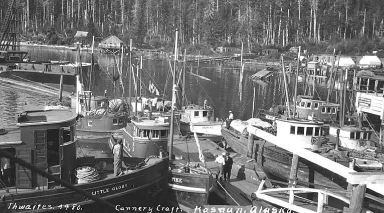
English: Caption on image: Cannery craft, Kasaan, Alaska PH Coll 247.641 Kasaan is situated on the east side of Prince of Wales Island on Kasaan Bay, 30 miles northwest of Ketchikan. Originally Tlingit territory, Kasaan gets its name from the Tlingit word meaning "pretty town." Haidas migrated north from the Queen Charlotte Islands in the early 1700s to the Island and established the village now known as "Old Kasaan" 7 miles south on Skowl Arm. In 1892 the Copper Queen mine, camp, sawmill, post office and store were built on Kasaan Bay, and the Haida people relocated to this new village. In 1902 the first salmon cannery was constructed in Kasaan. The cannery burned in 1907, 1910 and again in 1911, but was rebuilt each season. The cannery operated sporadically until 1953. During this time, Kasaan had a school, three stores, a Presbyterian Church and other businesses. Chief Sonihat built the Whale House, a traditional long house which became the focus of the new Kasaan Totem Park, established during the 1930s. Many of the totems left from the old village site were moved to the park in 1938. Kavilco, Inc., the local village corporation, purchased the old cannery buildings and property in 1974, and in 1980 removed the cannery buildings. Remnants of the historical Karta River village and petroglyphs lie north of the city, and the Old Tom Creek village and fort lie south of the city.
|
|||||||||||||||||||||||
| Depicted place | Kasaan, Alaska | |||||||||||||||||||||||
| Date | circa 1912 | |||||||||||||||||||||||
| Collection |
|
|||||||||||||||||||||||
| Accession number | ||||||||||||||||||||||||
| Source | ||||||||||||||||||||||||
| Permission (Reusing this file) |
|
|||||||||||||||||||||||
| Order Number | THW304 | |||||||||||||||||||||||
File history
Click on a date/time to view the file as it appeared at that time.
| Date/Time | Thumbnail | Dimensions | User | Comment | |
|---|---|---|---|---|---|
| current | 12:55, 27 October 2016 | | 766 × 426 (80 KB) | BMacZeroBot (talk | contribs) |
You cannot overwrite this file.
File usage on Commons
The following 3 pages use this file:
.jpeg)
.jpeg&oldid=306469501)