File:Fires in Northern Territory, Australia (MODIS 2018-06-19).jpg

Original file (1,920 × 1,491 pixels, file size: 343 KB, MIME type: image/jpeg)
Captions
Captions
Summary[edit]
.jpg&action=edit§ion=1)
| Description |
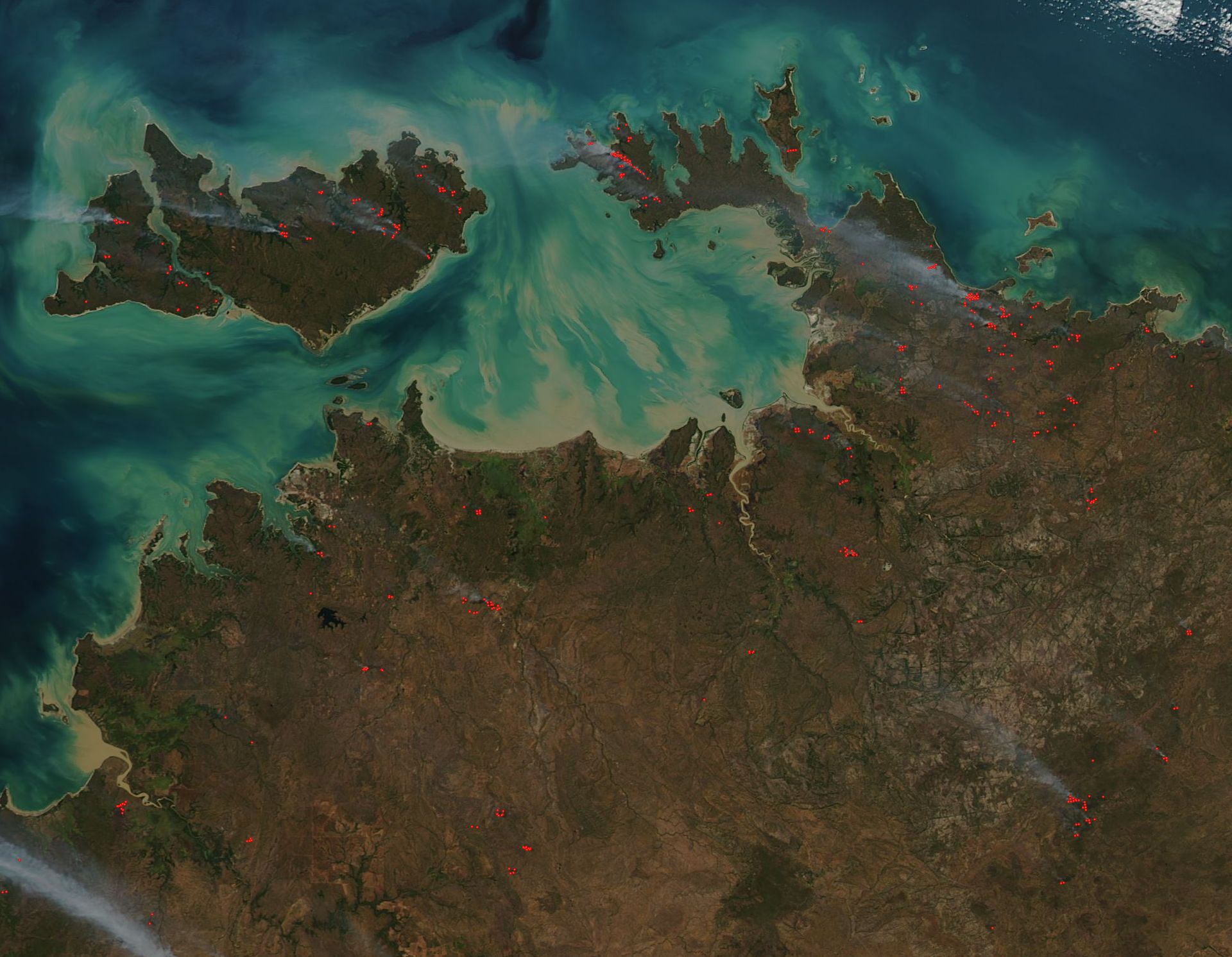
English: Fire is ubiquitous during Northern Territory’s dry season, which runs from April to December. As has been the case for months, the Moderate Resolution Imaging Spectroradiometer (MODIS) on board NASA’s Aqua satellite observed smoke and dozens of active fires as it passed over the region on June 17, 2018.
The type of vegetation burning varies with latitude. Areas nearest to the coast receive the most rain and support eucalyptus forests. Hummock grasslands grow in the drier areas, farther inland. Fires cluster most heavily in Australia’s “Top End”, particularly in Arnhemland. A number of fires were also concentrated on the Tiwi Islands. People play a pivotal role in causing most of the fires in Northern Territory. Indigenous Australian communities frequently use fire to aid with hunting, to prepare crops, to clear roads, and for several other purposes. There are a few cattle ranches in this area that also use fire to manage pasture land. Unusually dry weather in May primed the vegetation for burning. However, the total number of fires in Arnhem Land is running a bit lower than average for April through July according to a risk analyst with the Australian Capital Territory government. Still, the number of fires in Arnhem Land is still quite high in comparison to other parts of Australia. Fire counts are also higher than normal in the Tanami Desert, which usually sees the most activity in July and August. |
||
| Date | Taken on 17 June 2018 | ||
| Source |
Fires in Northern Territory, Australia (direct link)
|
||
| Author | Jeff Schmaltz, MODIS Land Rapid Response Team, NASA GSFC |
| This media is a product of the Aqua mission Credit and attribution belongs to the mission team, if not already specified in the "author" row |
Licensing[edit]
.jpg&action=edit§ion=2)
| This file is in the public domain in the United States because it was solely created by NASA. NASA copyright policy states that "NASA material is not protected by copyright unless noted". (See Template:PD-USGov, NASA copyright policy page or JPL Image Use Policy.) | ||
 |
Warnings:
|
File history
Click on a date/time to view the file as it appeared at that time.
| Date/Time | Thumbnail | Dimensions | User | Comment | |
|---|---|---|---|---|---|
| current | 01:41, 17 February 2024 | | 1,920 × 1,491 (343 KB) | OptimusPrimeBot (talk | contribs) | #Spacemedia - Upload of http://modis.gsfc.nasa.gov/gallery/images/image06192018_250m.jpg via Commons:Spacemedia |
You cannot overwrite this file.
File usage on Commons
There are no pages that use this file.
.jpg&oldid=855300591)